
Photo: Wikipedia
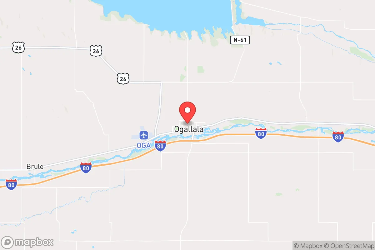
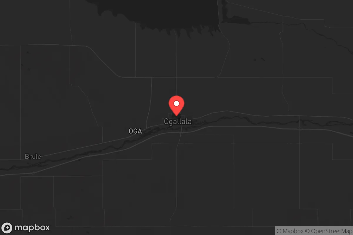
Strategic Assessment of Ogallala, NE
Deep buffer from population centers and strategic targets. Low natural disaster risk and minimal exposure to border or coastal threats.
What does the Strategic Assessment tell us?
Our Strategic Assessment grades tactical survivability of an area. Major population centers, military targets, fallout zones, natural disasters, and border exposure all drive risk — lower exposure means a more defensible position in a crisis.
This is heavily inspired by Joel Skousen's Strategic Relocation book. Highly recommended you checkout the book ($)What does this tell us?
Our Strategic Assessment grades tactical survivability of an area. Major population centers, military targets, fallout zones, natural disasters, and border exposure all drive risk — lower exposure means a more defensible position in a crisis.
This is heavily inspired by Joel Skousen's Strategic Relocation book. Highly recommended you checkout the book ($)Strategic Pillars

Key Distances
Regional Safe Places
Below is our recommended "safe zones" in Nebraska and the surrounding area based on our strategic heuristics. For most people, it's unrealistic to live in a “safe zone” full-time due to work, family or other personal reasons. They tend to be more rural. However, many of these areas are perfect for second homes and retreat properties that double as a vacation home or even a short-term rental.
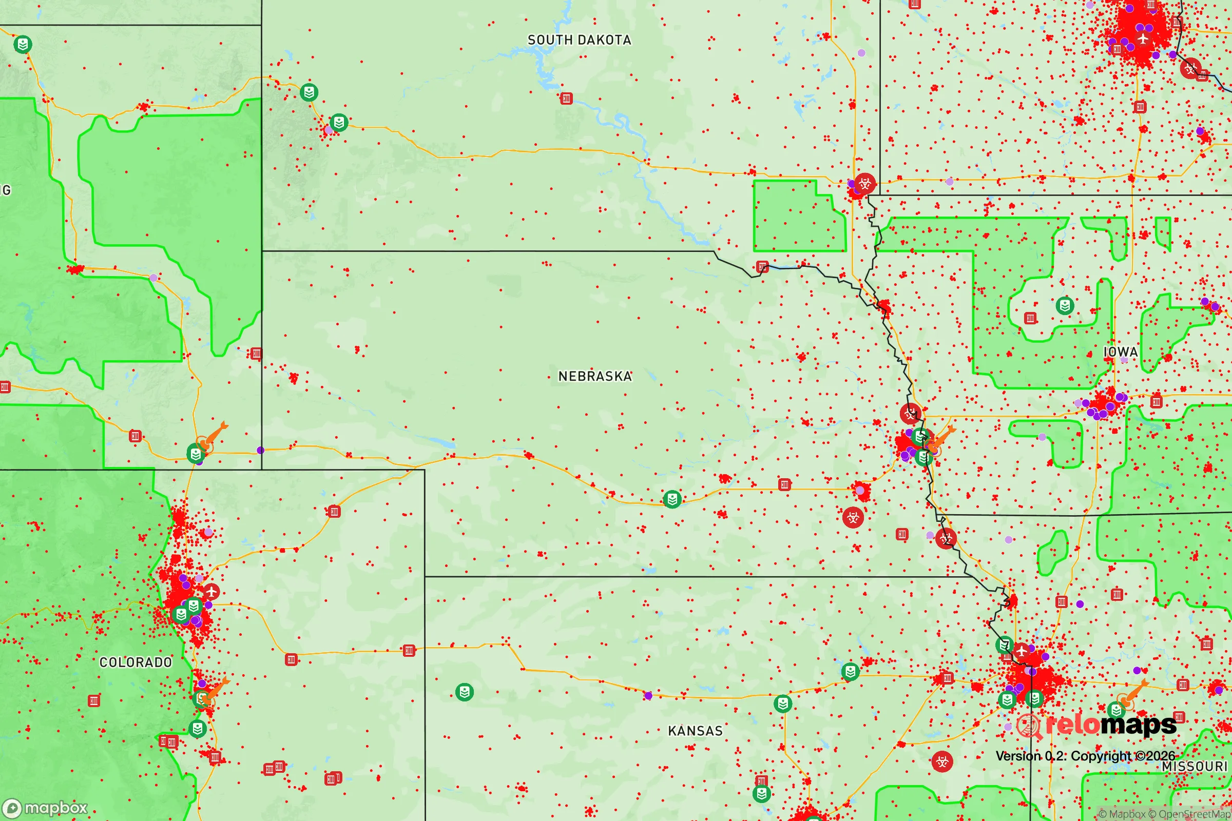
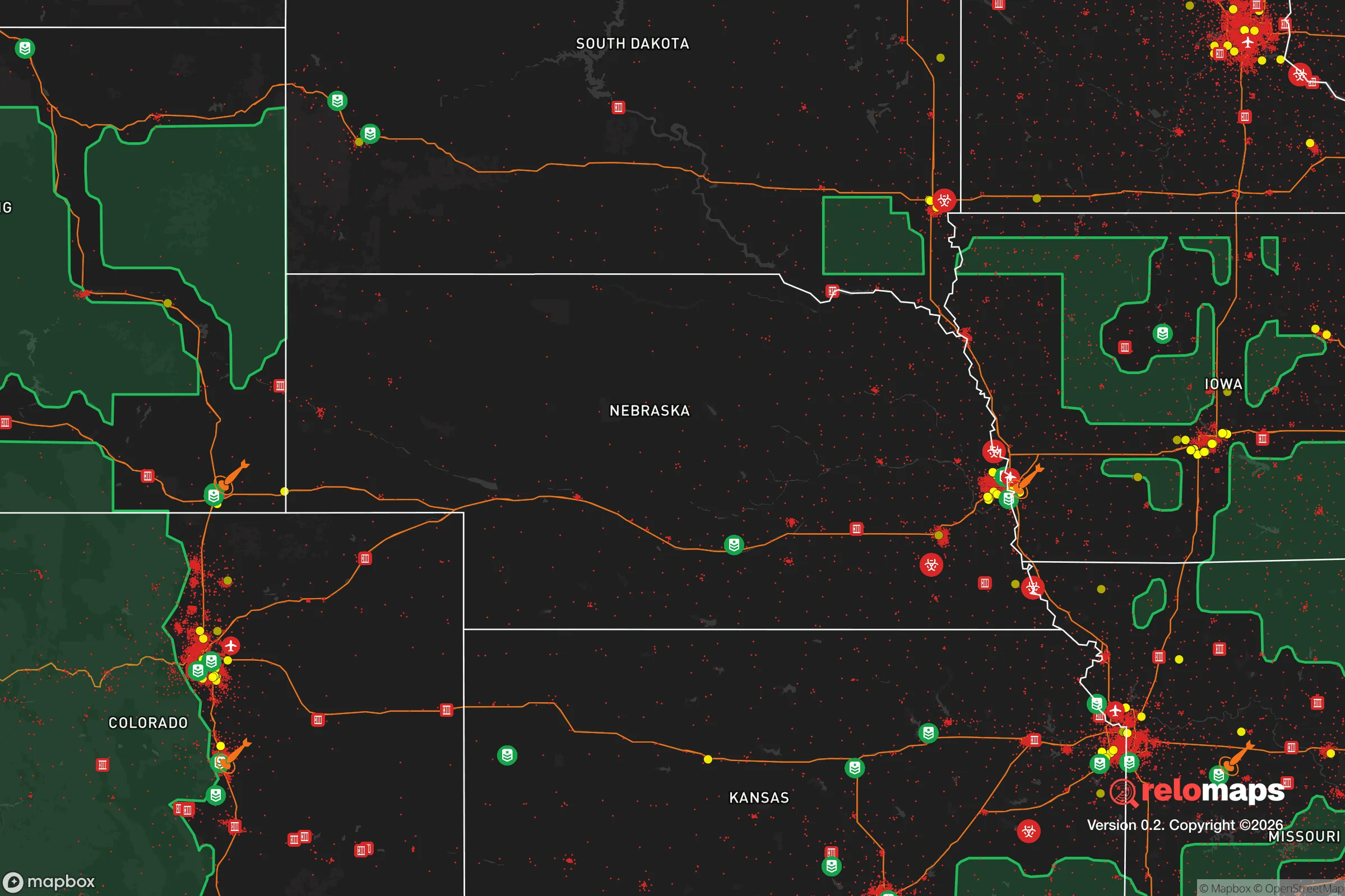
Important Note: For informational purposes only. This does not mean nothing bad ever happens in the green zones. Please use common sense. This is based on public data and modeled with AI. We tried to take a conservative approach but mistakes happen. We update this regularly as new information becomes available.
Solar Generator Recommendations
Backup power matters more here than in safer locations. We've picked three solar generators across budgets and capacity tiers — start with the budget unit if you only need a few essentials, or step up if you want to run a fridge and HVAC for days at a time.

Jackery Portable Power Station Explorer 300
Budget OptionPower on the Go: Weighing only 11 lbs, it's convenient to set up and store with book-sized foldable solar panels

BLUETTI Portable Power Station AC180
Designed for both indoor and outdoor scenarios, AC180 is highly capable as it has a robost capacity and continuous output power.

EF ECOFLOW DELTA Pro Ultra Power Station
Upgraded PickEcoFlow DELTA Pro Ultra is a whole-home energy system designed to grow with your family. Integrated with the Smart Home Panel 2, it scales to meet your evolving energy needs — keeping your home powered, intelligent, and secure through every stage of life.
We earn a commission, at no additional cost to you.
Strategic Assessment Analysis
Ogallala, Nebraska, sits as a quiet outlier on the Great Plains—a town of roughly 4,500 people that offers a rare combination of geographic isolation, resource independence, and logistical connectivity. Its position along the South Platte River and Interstate 80 gives it a strategic backbone that few similarly sized towns can match: it’s far enough from major population centers to avoid the immediate shockwaves of a national crisis, yet close enough to arterial routes to allow for resupply or relocation if needed. For a relocator thinking in terms of decades, not months, Ogallala represents a low-signature, high-resilience base of operations in a state that consistently ranks among the most politically stable and agriculturally self-sufficient in the country.
Geographic position and natural advantages for long-term security
Ogallala’s location is its primary strategic asset. It sits in Keith County, roughly 200 miles west of Lincoln and 230 miles east of Cheyenne, Wyoming—far enough from the Denver metro area (about 230 miles southwest) to avoid the fallout of a major urban collapse, but close enough to access the Front Range’s medical and logistical infrastructure in a non-crisis scenario. The town is anchored by the Ogallala Aquifer, one of the largest freshwater aquifers in the world, which underlies much of the region and provides a reliable, deep water source that is less vulnerable to surface contamination than rivers or reservoirs. The South Platte River runs through town, offering a secondary water source and riparian habitat that supports game and forage. The surrounding landscape is flat to gently rolling, with low population density—Keith County has about 8.5 people per square mile—which means limited competition for resources and a high degree of natural defensibility. The area’s agricultural base is dominated by cattle ranching and irrigated corn and alfalfa, giving it a built-in food production capacity that most suburban or exurban locations lack entirely.
Risks, exposures, and proximity to fallout-relevant landmarks
No location is without vulnerabilities, and Ogallala has a few that a serious prepper must account for. The most immediate concern is Interstate 80, which runs directly through town. In a mass evacuation scenario—whether from a natural disaster, a nuclear event on the East Coast, or a cascading grid failure—I-80 would become a chokepoint and a target for looting or refugee flow. Ogallala sits at the junction of I-80 and US Highway 61, making it a natural waypoint. During a crisis, the town could see a surge of transient traffic from the Denver-to-Omaha corridor, which would strain local law enforcement and medical resources. The Keith County Sheriff’s Office and Ogallala Police Department together field fewer than 20 sworn officers, so external security would depend heavily on community organization. Another exposure is the proximity to the Keystone XL pipeline corridor (though the pipeline itself is not operational as of 2026, the right-of-way and associated infrastructure remain) and the nearby Kingsley Dam, which impounds Lake McConaughy—a major recreational reservoir about 10 miles north. A dam failure or sabotage event could flood downstream areas, though Ogallala itself sits at a slightly higher elevation and is not in the direct inundation zone. Finally, the town is about 120 miles from the Nebraska Public Power District’s Cooper Nuclear Station near Brownville—close enough that a major release under prevailing westerly winds could deposit fallout in the region, though prevailing winds are generally from the northwest, pushing contamination toward the southeast and away from Ogallala.
Practical resilience for a relocator: food, water, energy, and defensibility
For a single individual or a family looking to establish a self-sufficient homestead, Ogallala offers a strong baseline. Water is the most critical resource, and the Ogallala Aquifer provides a deep, protected source that is less susceptible to drought than surface water. Private wells in the area typically produce 20–50 gallons per minute at depths of 100–300 feet, which is more than adequate for household use, irrigation, and livestock. The town’s municipal water system draws from the aquifer and the South Platte, but a well-equipped relocator should plan for a backup hand pump or solar-powered pump to maintain independence if the grid goes down. Food production is straightforward: the growing season runs about 150 days, with hot summers and cold winters, but cold-hardy crops like potatoes, carrots, kale, and winter squash do well. Local ranchers sell beef and bison directly, and the area has a strong hunting culture—deer, pronghorn, and waterfowl are abundant. Energy resilience is more challenging. Ogallala is served by the Nebraska Public Power District, which relies heavily on coal and nuclear generation. Solar potential is moderate—the area gets about 5.2 peak sun hours per day in summer, dropping to 2.5 in winter—so a hybrid system with wind (average wind speeds are 12–15 mph) and a propane or diesel backup generator is the most practical approach. Defensibility is good: the town is compact, with a grid street pattern that offers clear sightlines, and the surrounding farmland provides a natural buffer zone. There are no major military installations, nuclear weapons storage sites, or high-value industrial targets within 150 miles, which dramatically reduces the likelihood of a direct strike or secondary attack. The nearest Air Force base is Offutt near Omaha, about 250 miles east—well outside the immediate danger zone for a conventional or nuclear exchange.
The overall strategic picture for Ogallala is one of quiet competence. It is not a flashy location, nor one that offers the amenities of a mountain redoubt or a coastal retreat. What it provides is a stable, low-profile platform for long-term survival in a scenario where the national grid, supply chains, and social order are under severe stress. The town’s agricultural base, deep water access, and distance from major targets make it a defensible and sustainable choice for a relocator who values self-reliance over convenience. The primary risk—its position on a major interstate corridor—can be mitigated by choosing a property a few miles outside town, on a gravel road, with good visibility and a defensible perimeter. For a conservative-leaning individual or family looking to ride out the coming instability without drawing attention, Ogallala deserves a serious look. It is not a bunker; it is a base. And in a world where the margin for error is shrinking, that distinction matters.
* Values derived from national, state, county, city and local statistics and may differ in a specific area. Last updated: 2026-05-03T20:29:58.000Z
Narrative content on this page is AI-generated and may contain mistakes. Verify any details that matter before acting on them.
ReloMaps may earn a commission from affiliate links at no extra cost to you.