
Photo: Wikipedia
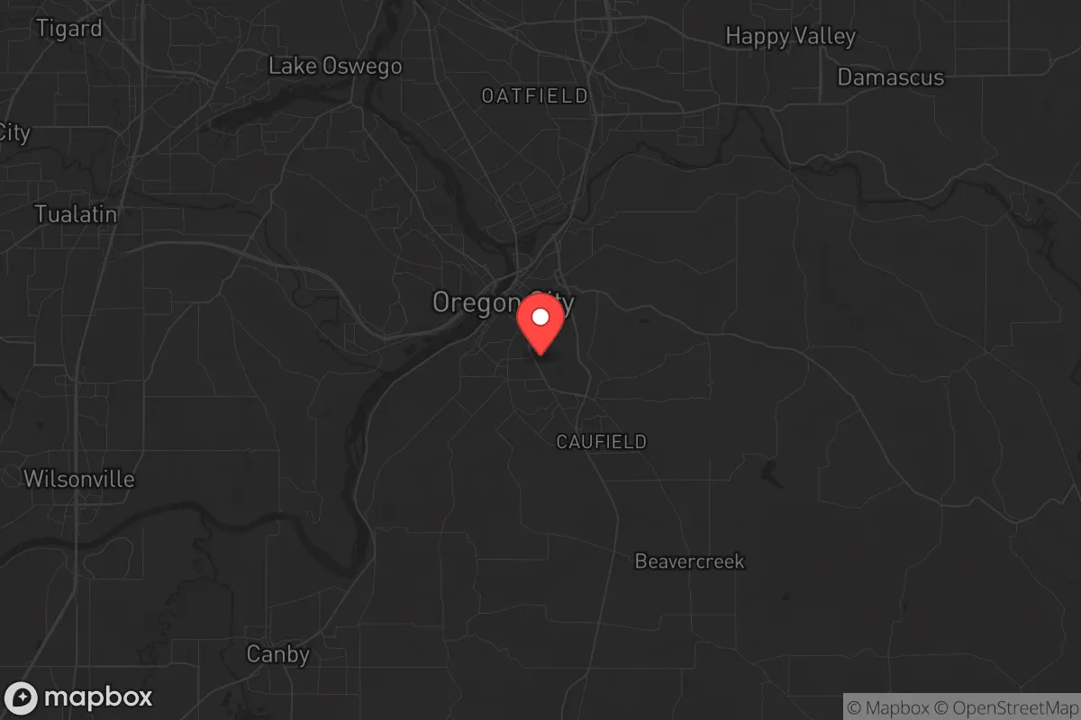
Strategic Assessment of Oregon City, OR
Multiple tactical vulnerabilities. Population density, target proximity, or disaster risk are likely compounding. A retreat property and exit planning is required.
What does the Strategic Assessment tell us?
Our Strategic Assessment grades tactical survivability of an area. Major population centers, military targets, fallout zones, natural disasters, and border exposure all drive risk — lower exposure means a more defensible position in a crisis.
This is heavily inspired by Joel Skousen's Strategic Relocation book. Highly recommended you checkout the book ($)What does this tell us?
Our Strategic Assessment grades tactical survivability of an area. Major population centers, military targets, fallout zones, natural disasters, and border exposure all drive risk — lower exposure means a more defensible position in a crisis.
This is heavily inspired by Joel Skousen's Strategic Relocation book. Highly recommended you checkout the book ($)Strategic Pillars

Key Distances
Regional Safe Places
Below is our recommended "safe zones" in Oregon and the surrounding area based on our strategic heuristics. For most people, it's unrealistic to live in a “safe zone” full-time due to work, family or other personal reasons. They tend to be more rural. However, many of these areas are perfect for second homes and retreat properties that double as a vacation home or even a short-term rental.


Important Note: For informational purposes only. This does not mean nothing bad ever happens in the green zones. Please use common sense. This is based on public data and modeled with AI. We tried to take a conservative approach but mistakes happen. We update this regularly as new information becomes available.
Solar Generator Recommendations
Backup power matters more here than in safer locations. We've picked three solar generators across budgets and capacity tiers — start with the budget unit if you only need a few essentials, or step up if you want to run a fridge and HVAC for days at a time.

Jackery Portable Power Station Explorer 300
Budget OptionPower on the Go: Weighing only 11 lbs, it's convenient to set up and store with book-sized foldable solar panels

BLUETTI Portable Power Station AC180
Designed for both indoor and outdoor scenarios, AC180 is highly capable as it has a robost capacity and continuous output power.

EF ECOFLOW DELTA Pro Ultra Power Station
Upgraded PickEcoFlow DELTA Pro Ultra is a whole-home energy system designed to grow with your family. Integrated with the Smart Home Panel 2, it scales to meet your evolving energy needs — keeping your home powered, intelligent, and secure through every stage of life.
We earn a commission, at no additional cost to you.
Strategic Assessment Analysis
Oregon City, Oregon, sits at a strategic crossroads that demands a hard-nosed assessment for anyone serious about long-term resilience. Its position along the Willamette River, 13 miles south of Portland, offers a mix of advantages and liabilities that a prepper or survivalist must weigh carefully. While the area’s natural resources and defensible terrain provide a foundation for self-reliance, its proximity to a major urban center and critical infrastructure introduces risks that cannot be ignored. This analysis strips away the marketing gloss and looks at Oregon City through the lens of preparedness, civic stability, and survival in an increasingly uncertain world.
Geographic position and natural advantages for long-term survival
Oregon City’s location is a double-edged sword, but the natural advantages are real and worth examining first. The city sits at the base of the Willamette Valley, flanked by the Cascade Range to the east and the Coast Range to the west. This creates a natural funnel for resources—water, timber, and arable land—that are critical for any extended disruption. The Willamette River itself is a reliable water source, though it requires treatment, and the surrounding hills offer elevation that can provide both defensive overlooks and escape routes into less populated forested areas. The climate is temperate, with ample rainfall averaging 40-50 inches annually, which supports year-round gardening and reduces the risk of drought compared to drier regions. For a relocator, the ability to grow food, harvest timber for fuel or shelter, and access clean water from multiple streams and springs in the nearby Mount Hood National Forest is a tangible asset. The area’s agricultural history also means that local farms and homesteads are still present, offering potential for barter and community-level food security in a collapse scenario.
Risks, exposures, and proximity to fallout-relevant landmarks
Now for the hard truths. Oregon City’s biggest liability is its proximity to Portland, a city that, in a crisis, would become a liability rather than a resource. Portland is a major population center with over 650,000 people, and in a grid-down or civil unrest event, that population would likely flow south along Interstate 205 and Highway 99E, both of which run directly through Oregon City. The city itself has a population of roughly 38,000, but it sits in Clackamas County, which has over 420,000 residents. That density means that any large-scale evacuation or panic from Portland would funnel through Oregon City’s narrow river corridors, creating choke points and potential conflict zones. Additionally, the Willamette River is a strategic waterway, but it also means that bridges—like the Oregon City Bridge and the Abernethy Bridge—become critical infrastructure that could be targeted or blocked. The proximity to the Portland International Airport, the Port of Portland, and major rail lines (including the Union Pacific mainline) makes the area a potential target for any adversary seeking to disrupt supply chains or transportation networks. For a survivalist, being within 15 miles of a major urban center is a significant risk, especially when considering the potential for civil unrest, mass casualty events, or even a coordinated attack on critical infrastructure. The area is also within the Cascadia Subduction Zone, meaning a major earthquake (the "Big One") would devastate the region, with Oregon City facing liquefaction risks along the river and potential isolation if bridges collapse.
Practical resilience for a relocator: food, water, energy, and defensibility
For someone looking to set up a resilient homestead or retreat, Oregon City offers a mixed bag. On the positive side, the area has strong potential for off-grid living. The climate supports year-round vegetable production, and the surrounding forests provide firewood and building materials. Water is abundant, but it requires filtration or boiling due to agricultural runoff and potential contamination from upstream sources. The city’s municipal water comes from the Clackamas River, which is a surface water source vulnerable to both natural and man-made contamination. A well is a better option, but drilling costs in the area can run $15,000-$30,000 depending on depth and rock. Solar energy is viable, though the region’s frequent cloud cover reduces efficiency; a hybrid system with wind or micro-hydro (if you have a stream) is more reliable. Defensibility is a challenge. Oregon City’s terrain is hilly, but the valley floor is open and exposed. The best defensive positions are on the higher ridges east of the city, like around the Oregon City Municipal Elevator area or further into the foothills near the Mount Hood National Forest. These areas offer natural barriers, limited road access, and the ability to observe approaching threats. However, the city itself is not easily defensible due to its river crossings and multiple entry points. For a single individual or family, the key is to avoid the urban core and focus on the rural outskirts, where you can establish a perimeter and maintain a low profile. Community-wise, Clackamas County has a mix of conservative and liberal populations, but the rural areas tend to lean more toward self-reliance and preparedness. There are local prepper groups and gun clubs, but they are not as organized as in more rural parts of the state like eastern Oregon. The legal environment is also a factor: Oregon has relatively strict gun laws, including a permit-to-purchase requirement and magazine capacity limits, which could be a concern for those prioritizing self-defense. On the plus side, the state has no sales tax, which helps with stockpiling supplies, and property taxes are moderate compared to other West Coast states.
The overall strategic picture for Oregon City is one of cautious opportunity. It is not a survivalist paradise—the proximity to Portland, the earthquake risk, and the population density in the valley are real liabilities. But for someone willing to put in the work, the natural resources, water availability, and temperate climate provide a solid foundation for long-term resilience. The key is to position yourself outside the city limits, on higher ground, with a reliable water source and a plan for self-defense. If you can secure a property with a well, solar panels, and good sightlines, Oregon City’s surroundings offer a viable base for weathering the storms ahead. Just don’t expect to hunker down in the city itself—that’s a trap. The real value is in the land and the community of like-minded individuals who are already there, quietly preparing. If you’re serious about relocation, come with a clear plan, a budget for infrastructure, and a willingness to adapt. The Willamette Valley can sustain you, but only if you treat it as a strategic asset, not a retirement destination.
* Values derived from national, state, county, city and local statistics and may differ in a specific area. Last updated: 2026-05-03T01:52:30.000Z
Narrative content on this page is AI-generated and may contain mistakes. Verify any details that matter before acting on them.
ReloMaps may earn a commission from affiliate links at no extra cost to you.