
Photo: Wikipedia
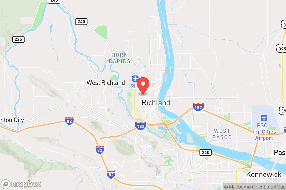
Strategic Assessment of Richland, WA
Workable tactical position. Some exposure to population density or targets, but generally defensible in a crisis.
What does the Strategic Assessment tell us?
Our Strategic Assessment grades tactical survivability of an area. Major population centers, military targets, fallout zones, natural disasters, and border exposure all drive risk — lower exposure means a more defensible position in a crisis.
This is heavily inspired by Joel Skousen's Strategic Relocation book. Highly recommended you checkout the book ($)What does this tell us?
Our Strategic Assessment grades tactical survivability of an area. Major population centers, military targets, fallout zones, natural disasters, and border exposure all drive risk — lower exposure means a more defensible position in a crisis.
This is heavily inspired by Joel Skousen's Strategic Relocation book. Highly recommended you checkout the book ($)Strategic Pillars

Key Distances
Regional Safe Places
Below is our recommended "safe zones" in Washington and the surrounding area based on our strategic heuristics. For most people, it's unrealistic to live in a “safe zone” full-time due to work, family or other personal reasons. They tend to be more rural. However, many of these areas are perfect for second homes and retreat properties that double as a vacation home or even a short-term rental.


Important Note: For informational purposes only. This does not mean nothing bad ever happens in the green zones. Please use common sense. This is based on public data and modeled with AI. We tried to take a conservative approach but mistakes happen. We update this regularly as new information becomes available.
Solar Generator Recommendations
Backup power matters more here than in safer locations. We've picked three solar generators across budgets and capacity tiers — start with the budget unit if you only need a few essentials, or step up if you want to run a fridge and HVAC for days at a time.

Jackery Portable Power Station Explorer 300
Budget OptionPower on the Go: Weighing only 11 lbs, it's convenient to set up and store with book-sized foldable solar panels

BLUETTI Portable Power Station AC180
Designed for both indoor and outdoor scenarios, AC180 is highly capable as it has a robost capacity and continuous output power.

EF ECOFLOW DELTA Pro Ultra Power Station
Upgraded PickEcoFlow DELTA Pro Ultra is a whole-home energy system designed to grow with your family. Integrated with the Smart Home Panel 2, it scales to meet your evolving energy needs — keeping your home powered, intelligent, and secure through every stage of life.
We earn a commission, at no additional cost to you.
Strategic Assessment Analysis
Richland, Washington, offers a surprisingly strong strategic position for those prioritizing resilience, combining geographic isolation from major coastal threats with access to the critical infrastructure of the Hanford Site. While the area’s association with nuclear history might raise eyebrows, its location in the semi-arid Columbia Basin provides a buffer against many natural disasters that plague other regions, and its economy is anchored by a federal presence that is unlikely to vanish in a crisis. For a relocator thinking in terms of decades, not just years, Richland presents a compelling mix of defensible terrain, water security, and energy independence—provided you understand and accept the unique risks that come with living next to a nuclear reservation.
Geographic position and natural advantages for long-term stability
Richland sits at the confluence of the Yakima, Snake, and Columbia Rivers, a hydrological asset that is almost impossible to overstate in a prepper context. The Columbia River alone provides an essentially unlimited freshwater source, and the region’s low annual rainfall (around 7 inches) means you are not fighting mold, flooding, or constant moisture degradation of supplies. The surrounding landscape is high desert sagebrush steppe, which offers excellent visibility and natural defensibility—few places for an adversary to approach unseen. The Cascade Range to the west acts as a massive weather and population barrier, shielding the Tri-Cities from the wet, densely populated coastal corridor. This geographic buffer means that a collapse scenario in Seattle or Portland would take days to ripple here, giving residents time to assess and react. The local topography is relatively flat but punctuated by ridges and basalt outcroppings, providing natural chokepoints and observation points for those who know where to look.
Risks, exposures, and proximity to fallout-relevant landmarks
The elephant in the room is the Hanford Site, a decommissioned nuclear production facility that sits just northwest of Richland. Hanford contains roughly 56 million gallons of high-level radioactive waste in aging underground tanks, and while the site is heavily monitored and guarded, a catastrophic tank failure or a deliberate attack on the facility would render large portions of the area uninhabitable for generations. This is not a theoretical risk—it is a concrete, ongoing liability that any serious relocator must weigh. Additionally, the Tri-Cities are within 200 miles of the Portland metro area (2.5 million people) and about 250 miles from Seattle-Tacoma (4 million people). In a mass evacuation scenario, highways I-82 and I-84 would become clogged arteries, and Richland could see a surge of desperate refugees from the west. The area is also within the fallout plume zone of a potential nuclear strike on the Pacific Northwest’s major military or economic targets, though the prevailing westerly winds would carry most contamination east toward the Palouse and Idaho. On the natural disaster front, the region is seismically active—the 2001 Nisqually earthquake was felt here—and the nearby Wallula Gap fault line is capable of a magnitude 6.5 or greater event. Flooding from the Columbia is a minor concern due to the extensive dam system, but a dam failure at Grand Coulee or Ice Harbor would be catastrophic for low-lying areas near the river.
Practical resilience for a relocator: food, water, energy, and defensibility
Water is Richland’s strongest card. The Columbia River is a year-round, high-volume source that is unlikely to be contaminated by local runoff, and the city’s water treatment infrastructure is modern and redundant. For a prepper, securing a private well or a river-access point with a good filtration system is straightforward. Food resilience is moderate: the surrounding Columbia Basin is one of the most productive agricultural regions in the country, with apples, cherries, potatoes, and wine grapes grown in abundance. However, most of this produce is shipped out of state, so local grocery stores rely on the same just-in-time supply chains as everywhere else. A savvy relocator should establish relationships with local farmers and consider a small acreage property for personal food production—the growing season is short (about 150 frost-free days) but the soil is fertile with irrigation. Energy is a major plus: the region is powered by the Columbia River dams, providing cheap, reliable hydroelectricity that is less vulnerable to grid collapse than coal or natural gas plants. Solar potential is excellent, with over 300 days of sunshine per year, and wind power is abundant on the surrounding ridges. Defensibility is mixed. Richland itself is a suburban sprawl of cul-de-sacs and strip malls, not ideal for a last-stand scenario. But the rural areas to the north and east—toward the Horse Heaven Hills or the Rattlesnake Mountain range—offer isolated properties with long sightlines and limited access roads. The local population is generally conservative, self-reliant, and armed, which means a community defense network could form organically in a crisis. The presence of the Hanford Site also means a significant federal law enforcement and military security presence in the area, which could be either a stabilizing force or a target, depending on the nature of the collapse.
The overall strategic picture for Richland is one of high potential reward paired with a single, non-negotiable risk. If you can accept the Hanford liability—and many locals do, having lived with it for decades—the area offers water security, energy independence, a strong agricultural base, and a population that is culturally aligned with self-sufficiency and preparedness. The isolation from coastal chaos is real, but so is the proximity to Portland and Seattle in an evacuation scenario. For a single individual or a family willing to invest in a well, solar panels, and a rural property with good defensibility, Richland is one of the more viable long-term relocation options in the Pacific Northwest. Just keep a radiation detector in your go-bag and know the prevailing wind direction. That’s not paranoia—that’s geography.
* Values derived from national, state, county, city and local statistics and may differ in a specific area. Last updated: 2026-04-21T10:57:46.000Z
Narrative content on this page is AI-generated and may contain mistakes. Verify any details that matter before acting on them.
ReloMaps may earn a commission from affiliate links at no extra cost to you.