
Photo: Wikipedia
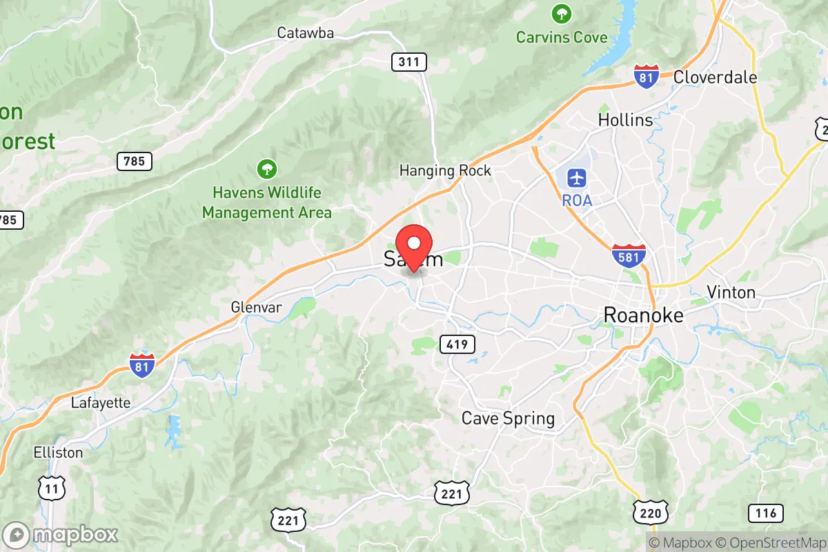
Strategic Assessment of Salem, VA
Workable tactical position. Some exposure to population density or targets, but generally defensible in a crisis.
What does the Strategic Assessment tell us?
Our Strategic Assessment grades tactical survivability of an area. Major population centers, military targets, fallout zones, natural disasters, and border exposure all drive risk — lower exposure means a more defensible position in a crisis.
This is heavily inspired by Joel Skousen's Strategic Relocation book. Highly recommended you checkout the book ($)What does this tell us?
Our Strategic Assessment grades tactical survivability of an area. Major population centers, military targets, fallout zones, natural disasters, and border exposure all drive risk — lower exposure means a more defensible position in a crisis.
This is heavily inspired by Joel Skousen's Strategic Relocation book. Highly recommended you checkout the book ($)Strategic Pillars

Key Distances
Regional Safe Places
Below is our recommended "safe zones" in Virginia and the surrounding area based on our strategic heuristics. For most people, it's unrealistic to live in a “safe zone” full-time due to work, family or other personal reasons. They tend to be more rural. However, many of these areas are perfect for second homes and retreat properties that double as a vacation home or even a short-term rental.


Important Note: For informational purposes only. This does not mean nothing bad ever happens in the green zones. Please use common sense. This is based on public data and modeled with AI. We tried to take a conservative approach but mistakes happen. We update this regularly as new information becomes available.
Solar Generator Recommendations
Backup power matters more here than in safer locations. We've picked three solar generators across budgets and capacity tiers — start with the budget unit if you only need a few essentials, or step up if you want to run a fridge and HVAC for days at a time.

Jackery Portable Power Station Explorer 300
Budget OptionPower on the Go: Weighing only 11 lbs, it's convenient to set up and store with book-sized foldable solar panels

BLUETTI Portable Power Station AC180
Designed for both indoor and outdoor scenarios, AC180 is highly capable as it has a robost capacity and continuous output power.

EF ECOFLOW DELTA Pro Ultra Power Station
Upgraded PickEcoFlow DELTA Pro Ultra is a whole-home energy system designed to grow with your family. Integrated with the Smart Home Panel 2, it scales to meet your evolving energy needs — keeping your home powered, intelligent, and secure through every stage of life.
We earn a commission, at no additional cost to you.
Strategic Assessment Analysis
Salem, Virginia, sits in a geographic sweet spot that offers genuine strategic depth for those thinking about long-term resilience, but it’s not without its own set of vulnerabilities. Tucked into the Roanoke Valley between the Blue Ridge and Allegheny Mountains, this small city of roughly 25,000 people benefits from a location that is far enough from major metropolitan chaos to provide a buffer, yet close enough to critical infrastructure to make daily life practical. For a relocator with a prepper mindset, Salem’s real advantage is its position as a secondary hub—less likely to be a primary target in a national crisis, but still connected enough to sustain a post-event recovery. The key is understanding where the risks actually lie and whether the area’s natural and built assets can offset them.
Geographic position and natural advantages for long-term security
Salem’s geography is its strongest card. Nestled in the Great Valley of Virginia, the city is shielded by the Blue Ridge Mountains to the east and the Allegheny Front to the west, creating a natural funnel that limits approach vectors for any large-scale movement—whether that’s a fleeing population or a coordinated threat. The Roanoke River runs through the valley, providing a reliable freshwater source, and the surrounding national forests (Jefferson National Forest is minutes away) offer both timber resources and game for those who know how to use them. The elevation sits around 1,100 feet, which means summers are milder than the Piedmont and winters bring manageable snow—enough to slow travel but not enough to trap you. For a conservative-leaning prepper, this terrain offers defensible chokepoints: the major routes in and out are limited to I-81, US-11, and US-460, all of which can be monitored or blocked if needed. The valley’s agricultural history also means the soil is decent for small-scale food production, and there are still working farms within a 15-minute drive of downtown. In a grid-down scenario, Salem’s position as a secondary population center means it would likely see less looting and civil disorder than Roanoke proper, which is only 5 miles east but has a population density nearly three times higher.
Risks, exposures, and proximity to fallout-relevant landmarks
No strategic assessment is honest without naming the hard truths, and Salem has a few. The most obvious risk is its proximity to Roanoke—a city of 100,000 that sits on I-81, a major north-south logistics corridor. In a mass evacuation event, Roanoke’s population could easily spill into Salem, overwhelming local resources. The Roanoke-Blacksburg Regional Airport, about 10 miles away, is a potential target for any coordinated attack on transportation infrastructure, and the nearby Radford Army Ammunition Plant (30 miles southwest) is a legitimate military-industrial target that could produce secondary effects if compromised. Salem itself has no major military bases or nuclear facilities, which is a plus, but the Salem Veterans Affairs Medical Center is a high-profile federal facility that could become a target for symbolic attacks or civil unrest. The biggest concern for a prepper is the I-81 corridor itself: it’s a critical supply route for the East Coast, and any disruption—whether from a natural disaster, a cyberattack on the rail system, or civil unrest—would choke the valley. The 2020 civil unrest in Roanoke, which saw property damage and looting, demonstrated that even smaller cities aren’t immune to cascading chaos. Additionally, the region sits in a seismic zone (the Central Virginia Seismic Zone), and while major quakes are rare, the 2011 Mineral earthquake (5.8 magnitude) was felt strongly here and could have damaged older infrastructure. Flooding along the Roanoke River is a recurring issue, with the 1985 flood (from Hurricane Juan) causing over $100 million in damage in the valley—a reminder that natural disasters can be just as destabilizing as man-made ones.
Practical resilience for a relocator: food, water, energy, and defensibility
For someone serious about self-sufficiency, Salem offers a mixed bag. The water situation is solid: the city draws from the Roanoke River and Carvins Cove Reservoir, which holds over 12 billion gallons and is protected by a 12,000-acre watershed. In a prolonged grid-down event, gravity-fed systems from the mountains could still provide water to lower elevations, though you’d want a backup filtration system. Food security is more of a challenge. Salem is not a major agricultural producer—most of the valley’s farmland is in Botetourt and Montgomery counties—but local farmers’ markets and CSAs are active, and the city’s zoning allows for backyard chickens and small gardens in most residential areas. The bigger issue is energy: Salem is served by Appalachian Power, which relies on a mix of coal, natural gas, and hydro. The grid here is moderately reliable, but the mountainous terrain makes it vulnerable to ice storms and wind events that can knock out power for days. Solar is a viable option, with the area averaging 200 sunny days per year, but you’ll need battery storage to handle the valley’s frequent cloud cover. Defensibility is where Salem shines for a small-group prepper. The city’s layout is compact, with a historic downtown grid that can be secured with minimal effort, and the surrounding neighborhoods are mostly single-family homes with yards and basements. The nearby mountains offer bug-out locations within a 30-minute drive, and the George Washington and Jefferson National Forests provide hundreds of thousands of acres of public land for those who want a remote cache. The local law enforcement presence is solid—Salem has its own police department, and the Roanoke County Sheriff’s Office is professional—but in a widespread crisis, you’d be relying on your own group and neighbors. The community itself leans conservative, with a strong veteran presence (the VA hospital brings in a steady population of former military), which means there’s a higher-than-average baseline of firearms ownership and practical skills among the population.
Overall, Salem presents a viable but not perfect option for the strategic relocator. Its natural barriers and moderate distance from major targets give it a resilience edge over most cities in the Mid-Atlantic, but the I-81 corridor and proximity to Roanoke introduce real risks that can’t be ignored. For a single individual or a family willing to invest in off-grid water, solar backup, and a solid community network, Salem offers a defensible base with access to wilderness and a like-minded population. The key is to treat it as a staging ground—not a final fortress—and to have a plan for both sheltering in place and moving deeper into the mountains if the situation deteriorates. In a world where the next crisis could come from any direction, Salem’s balance of isolation and connection makes it a smart bet, provided you go in with eyes open and supplies ready.
* Values derived from national, state, county, city and local statistics and may differ in a specific area. Last updated: 2026-05-01T02:56:09.000Z
Narrative content on this page is AI-generated and may contain mistakes. Verify any details that matter before acting on them.
ReloMaps may earn a commission from affiliate links at no extra cost to you.