Photo: Wikipedia
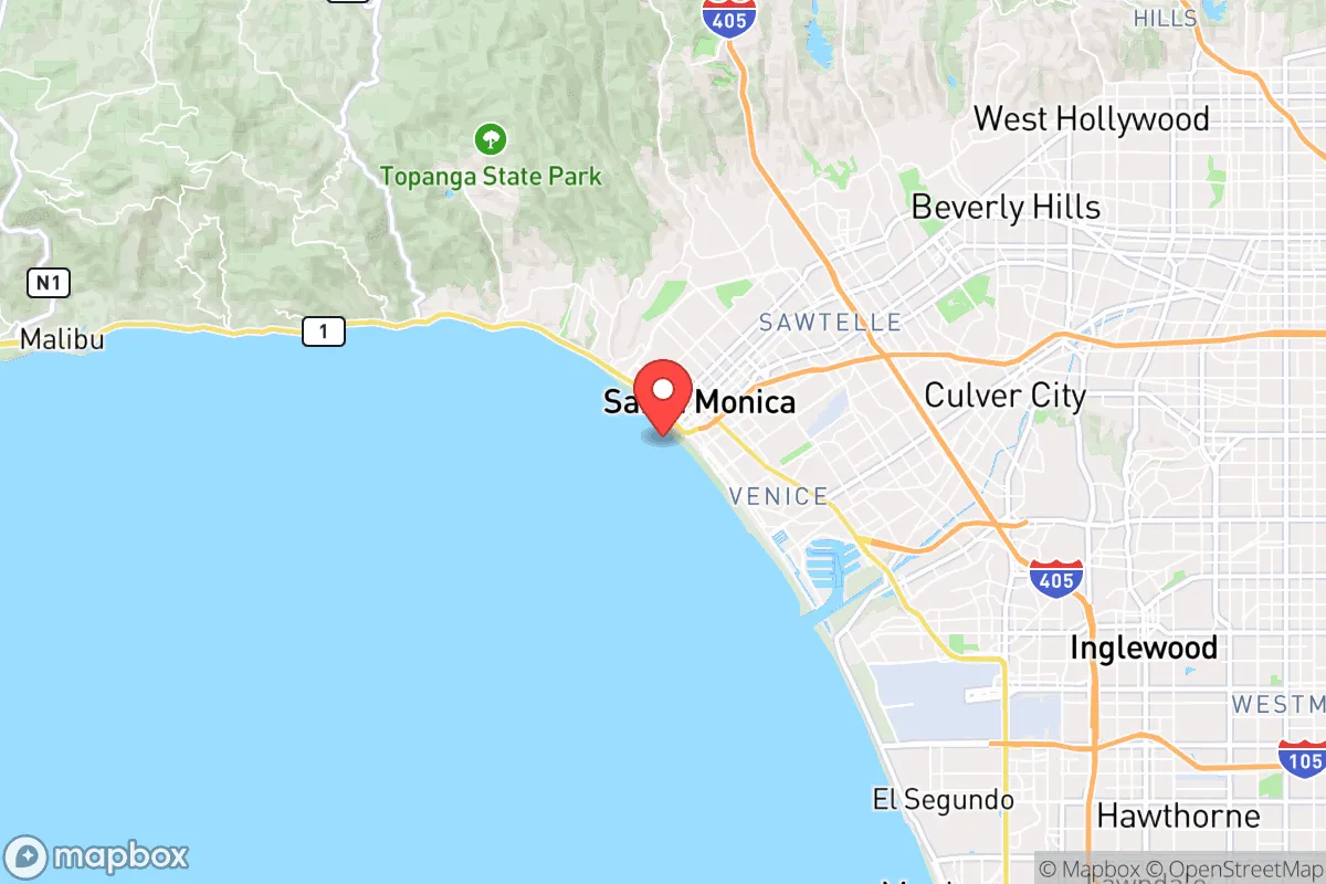
Strategic Assessment of Santa Monica, CA
High tactical risk. This location is likely close to major population centers, strategic targets, or sits in a high-disaster corridor. A retreat property and careful exit planning is required.
What does the Strategic Assessment tell us?
Our Strategic Assessment grades tactical survivability of an area. Major population centers, military targets, fallout zones, natural disasters, and border exposure all drive risk — lower exposure means a more defensible position in a crisis.
This is heavily inspired by Joel Skousen's Strategic Relocation book. Highly recommended you checkout the book ($)What does this tell us?
Our Strategic Assessment grades tactical survivability of an area. Major population centers, military targets, fallout zones, natural disasters, and border exposure all drive risk — lower exposure means a more defensible position in a crisis.
This is heavily inspired by Joel Skousen's Strategic Relocation book. Highly recommended you checkout the book ($)Strategic Pillars

Key Distances
Regional Safe Places
Below is our recommended "safe zones" in California and the surrounding area based on our strategic heuristics. For most people, it's unrealistic to live in a “safe zone” full-time due to work, family or other personal reasons. They tend to be more rural. However, many of these areas are perfect for second homes and retreat properties that double as a vacation home or even a short-term rental.


Important Note: For informational purposes only. This does not mean nothing bad ever happens in the green zones. Please use common sense. This is based on public data and modeled with AI. We tried to take a conservative approach but mistakes happen. We update this regularly as new information becomes available.
Solar Generator Recommendations
Backup power matters more here than in safer locations. We've picked three solar generators across budgets and capacity tiers — start with the budget unit if you only need a few essentials, or step up if you want to run a fridge and HVAC for days at a time.

Jackery Portable Power Station Explorer 300
Budget OptionPower on the Go: Weighing only 11 lbs, it's convenient to set up and store with book-sized foldable solar panels

BLUETTI Portable Power Station AC180
Designed for both indoor and outdoor scenarios, AC180 is highly capable as it has a robost capacity and continuous output power.

EF ECOFLOW DELTA Pro Ultra Power Station
Upgraded PickEcoFlow DELTA Pro Ultra is a whole-home energy system designed to grow with your family. Integrated with the Smart Home Panel 2, it scales to meet your evolving energy needs — keeping your home powered, intelligent, and secure through every stage of life.
We earn a commission, at no additional cost to you.
Strategic Assessment Analysis
Santa Monica presents a paradox for the strategic relocator: it offers exceptional natural resilience in its coastal microclimate and geographic position, yet sits within one of the highest-concentration target zones on the West Coast. For a single individual or family weighing disaster readiness, the city’s advantages are real but tightly bounded by its proximity to Los Angeles’s dense urban core, major infrastructure, and symbolic targets. This assessment weighs those factors without alarmism, focusing on what a prepared household can realistically expect.
Geographic position and natural advantages for long-term stability
Santa Monica’s location on the Santa Monica Bay provides a moderating marine influence that keeps temperatures mild year-round, typically 60–75°F, reducing the strain on heating and cooling systems during grid outages. The city sits on a relatively stable coastal plain, with the Santa Monica Mountains rising immediately to the north, offering a natural barrier against the worst of inland heat waves and Santa Ana wind events. The prevailing westerly winds from the Pacific push smoke, ash, and airborne contaminants away from the immediate coast during wildfire episodes, a meaningful advantage over inland communities like the San Fernando Valley or Simi Valley that frequently choke on smoke during fire season.
The city’s water supply is a genuine strategic asset. Santa Monica draws from its own groundwater basin via the Santa Monica Groundwater Project, which treats local water to meet about 70% of demand, supplemented by imported State Water Project deliveries. This local source reduces dependence on the fragile aqueduct systems that cross earthquake-prone fault lines. For a relocator, this means a lower likelihood of prolonged water outages compared to communities reliant entirely on the Los Angeles Aqueduct or Colorado River transfers. The city also maintains a network of 11 public hydration stations and has invested in backup well capacity, though these are designed for short-term emergencies rather than long-term self-sufficiency.
Seismic risk is real but manageable. The city lies within a few miles of the active Santa Monica Fault and the larger Newport-Inglewood Fault zone. The underlying geology is mostly alluvial sand and gravel, which can amplify shaking during a major quake. However, modern building codes in Santa Monica are among the strictest in California, with mandatory retrofitting of soft-story apartments and non-ductile concrete buildings. A relocator choosing a post-1980 structure or a retrofitted single-family home significantly reduces structural risk. The city’s tsunami inundation zone covers low-lying areas west of Ocean Avenue and around the pier; anyone living east of Lincoln Boulevard or above the coastal bluffs is effectively outside that hazard.
Risks, exposures, and proximity to fallout-relevant landmarks
The dominant strategic liability is Santa Monica’s location within the Los Angeles metropolitan area, which contains multiple high-value targets in a conflict scenario. The Port of Los Angeles and Port of Long Beach, roughly 20 miles south, are the busiest container ports in the Western Hemisphere. The Los Angeles International Airport (LAX) is 4 miles southeast. The region also hosts major aerospace and defense contractors, including Northrop Grumman and Raytheon facilities, as well as the Space Force’s Los Angeles Air Force Base in El Segundo, 5 miles south. In a nuclear exchange, these would be primary or secondary targets, and Santa Monica’s proximity places it within moderate-to-severe fallout zones depending on wind direction. The prevailing westerlies would carry fallout out to sea, but a shift to offshore winds—common during Santa Ana conditions—would push contamination directly over the city.
Civil unrest and crime are more immediate concerns. Santa Monica’s property crime rate is elevated relative to national averages, with theft and vehicle break-ins being the most common incidents. The city’s Third Street Promenade and downtown areas have seen periodic spikes in smash-and-grab robberies and organized retail theft. For a relocator, this means hardening a residence with good lighting, solid doors, and a security system is a practical necessity rather than a theoretical precaution. The city’s police department is well-funded and responsive, but response times can stretch during large-scale events like protests or natural disasters. The 2020 civil unrest saw looting and fires in downtown Santa Monica, demonstrating that even affluent coastal enclaves are not insulated from urban instability.
Wildfire risk is moderate but concentrated. The Santa Monica Mountains to the north experience regular fire seasons, and the 2018 Woolsey Fire came within a few miles of the city’s northern boundary. Homes in the Santa Monica Canyon area or near Topanga State Park face the highest direct threat. The city’s fire department maintains a robust vegetation management program and defensible space inspections, but a relocator in those zones should have a go-bag and evacuation plan ready annually from June through November.
Practical resilience for a relocator: food, water, energy, and defensibility
Food security in Santa Monica is a mixed picture. The city hosts three weekly farmers’ markets, including the large downtown market on Wednesdays and Saturdays, offering locally grown produce year-round. Several grocery chains—Whole Foods, Trader Joe’s, Ralphs—are distributed across the city, but supply chains are vulnerable to port disruptions, trucking strikes, or highway closures. A prepared household should maintain a minimum 30-day supply of non-perishable food, as store shelves emptied within 48 hours during the early COVID-19 panic. Community gardens exist but are small and have waiting lists; serious self-sufficiency in food production is not realistic within city limits.
Energy resilience is improving but not yet robust. Southern California Edison provides electricity, and the grid is prone to Public Safety Power Shutoffs during high-wind events, though Santa Monica’s coastal location reduces this risk compared to inland foothill communities. Solar adoption is high, with many homes and commercial buildings generating power, but battery storage is still uncommon. A relocator investing in a home solar-plus-battery system can achieve near-independence during daytime outages, though winter cloud cover and marine layer can reduce generation by 30–50%. Natural gas service is generally reliable, but a major earthquake could rupture lines, so a propane backup for cooking and heating is advisable.
Defensibility is poor by design. Santa Monica is a dense, walkable city with a grid street pattern and multiple access points from the 10 Freeway, Pacific Coast Highway, and surface streets. There is no natural chokepoint to control movement into or out of the city. During an evacuation, the primary routes—the 10 Freeway eastbound, PCH north and south, and local streets like Wilshire and Santa Monica Boulevard—would gridlock rapidly. The city’s population of roughly 90,000 swells with daytime workers and tourists, making egress a serious challenge. For a relocator, the best strategy is to have a secondary evacuation route mapped that avoids freeways entirely, using surface streets like Bundy Drive or Centinela Avenue to reach inland staging areas.
Community preparedness infrastructure is above average. The city operates a robust Office of Emergency Management with a well-maintained AlertSantaMonica notification system, multiple disaster supply caches, and a Community Emergency Response Team (CERT) program that trains residents in basic disaster response. The Santa Monica Fire Department stations are strategically placed, and the city has mutual aid agreements with Los Angeles County and neighboring cities. For a relocator willing to engage with CERT and build neighborhood-level connections, this network provides a meaningful force multiplier during the first 72 hours of a crisis.
Overall, Santa Monica offers a livable environment with genuine natural advantages—stable climate, local water, and moderate wildfire risk—but its strategic value is heavily discounted by its location within a high-target metropolitan area. For a relocator whose primary concern is long-term self-sufficiency and isolation from cascading urban risks, the city is a poor fit. For someone who values coastal lifestyle and professional opportunity but is willing to invest in home hardening, supplies, and an evacuation plan, it can work as a base of operations—provided they accept that in a worst-case scenario, the best move is to leave early and not look back.
* Values derived from national, state, county, city and local statistics and may differ in a specific area. Last updated: 2026-06-08T04:53:42.000Z
Narrative content on this page is AI-generated and may contain mistakes. Verify any details that matter before acting on them.
ReloMaps may earn a commission from affiliate links at no extra cost to you.