Photo: Wikipedia
Strategic Assessment of Scranton, PA
Multiple tactical vulnerabilities. Population density, target proximity, or disaster risk are likely compounding. A retreat property and exit planning is required.
What does the Strategic Assessment tell us?
Our Strategic Assessment grades tactical survivability of an area. Major population centers, military targets, fallout zones, natural disasters, and border exposure all drive risk — lower exposure means a more defensible position in a crisis.
This is heavily inspired by Joel Skousen's Strategic Relocation book. Highly recommended you checkout the book ($)What does this tell us?
Our Strategic Assessment grades tactical survivability of an area. Major population centers, military targets, fallout zones, natural disasters, and border exposure all drive risk — lower exposure means a more defensible position in a crisis.
This is heavily inspired by Joel Skousen's Strategic Relocation book. Highly recommended you checkout the book ($)Strategic Pillars

Key Distances
Regional Safe Places
Below is our recommended "safe zones" in Pennsylvania and the surrounding area based on our strategic heuristics. For most people, it's unrealistic to live in a “safe zone” full-time due to work, family or other personal reasons. They tend to be more rural. However, many of these areas are perfect for second homes and retreat properties that double as a vacation home or even a short-term rental.


Important Note: For informational purposes only. This does not mean nothing bad ever happens in the green zones. Please use common sense. This is based on public data and modeled with AI. We tried to take a conservative approach but mistakes happen. We update this regularly as new information becomes available.
Solar Generator Recommendations
Backup power matters more here than in safer locations. We've picked three solar generators across budgets and capacity tiers — start with the budget unit if you only need a few essentials, or step up if you want to run a fridge and HVAC for days at a time.

Jackery Portable Power Station Explorer 300
Budget OptionPower on the Go: Weighing only 11 lbs, it's convenient to set up and store with book-sized foldable solar panels

BLUETTI Portable Power Station AC180
Designed for both indoor and outdoor scenarios, AC180 is highly capable as it has a robost capacity and continuous output power.

EF ECOFLOW DELTA Pro Ultra Power Station
Upgraded PickEcoFlow DELTA Pro Ultra is a whole-home energy system designed to grow with your family. Integrated with the Smart Home Panel 2, it scales to meet your evolving energy needs — keeping your home powered, intelligent, and secure through every stage of life.
We earn a commission, at no additional cost to you.
Strategic Assessment Analysis
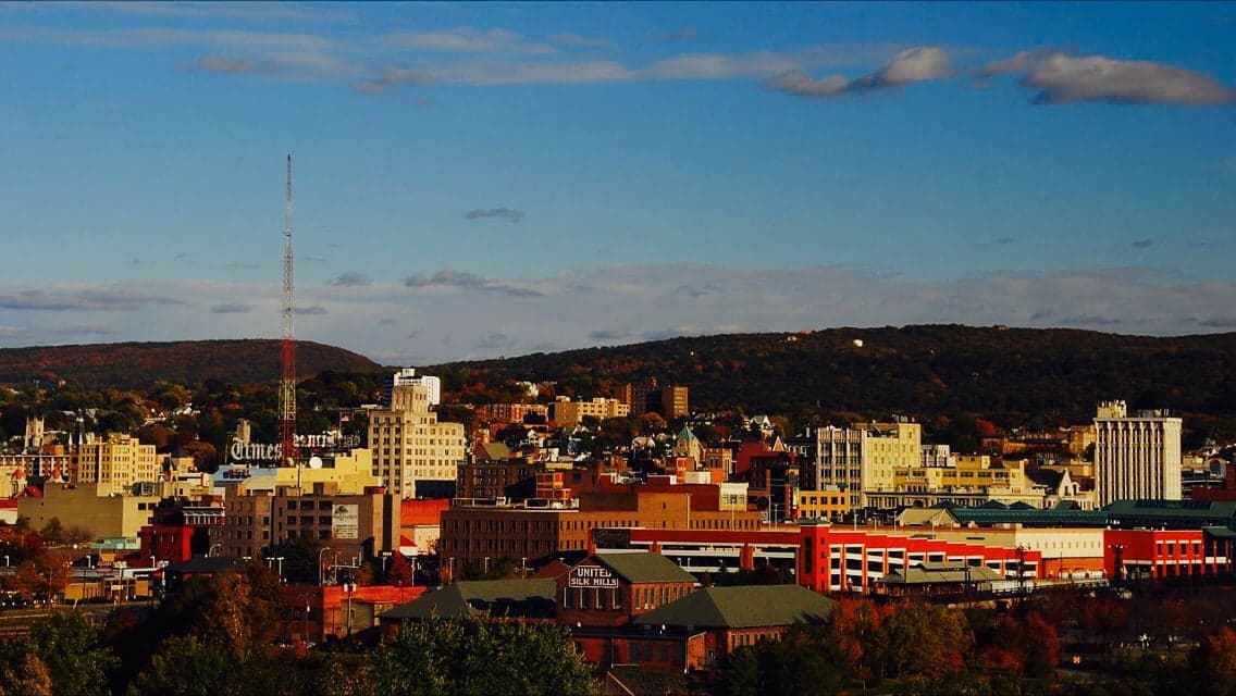
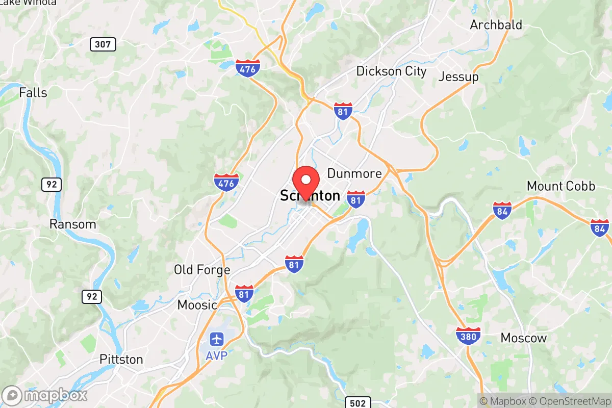
Scranton, Pennsylvania, sits in a geographic sweet spot that offers genuine strategic depth for those thinking seriously about resilience, but it comes with real trade-offs. Nestled in the Lackawanna River Valley and surrounded by the ridges of the Pocono Plateau, the city is roughly 120 miles from both New York City and Philadelphia—close enough to monitor events, far enough to avoid the immediate blast radius of a major urban catastrophe. The region’s population has been flat or declining for decades, which means less competition for resources in a crisis, but also a weaker local economy and aging infrastructure. For a relocator with a prepper mindset, Scranton’s core advantage is its position as a secondary hub in a state that has both rural farmland and mountainous terrain within an hour’s drive, giving you options to bug in or bug out depending on the threat.
Geographic position and natural advantages for long-term survival
Scranton’s location in northeastern Pennsylvania places it in the heart of the Appalachian region, a zone that has historically been a refuge during national disruptions. The city itself sits at roughly 750 feet elevation, with the surrounding Moosic Mountains and Lackawanna State Forest rising to over 2,000 feet. This topography provides natural defensibility—enemy movement through the narrow valleys is easily observed, and the ridges offer excellent line-of-sight for communications or observation posts. The area is rich in surface water: the Lackawanna River runs through downtown, and dozens of smaller creeks and ponds dot the surrounding townships. The region’s annual rainfall of about 40 inches means water scarcity is unlikely, and the deep, rocky soils support hardwood forests that can provide fuel, building material, and game. The climate is four-season, with cold winters that serve as a natural deterrent to unprepared transient populations—something to factor in if you’re planning for a long-term collapse scenario. The relative isolation from major interstate corridors (I-81 runs through, but it’s not a primary east-west artery) means that Scranton is less likely to be a target for large-scale refugee flows compared to cities like Harrisburg or Allentown.
Risks, exposures, and proximity to fallout-relevant landmarks
The biggest strategic liability for Scranton is its proximity to the New York City metropolitan area, which is roughly a two-hour drive under normal conditions. In a mass evacuation scenario, that distance shrinks to zero—I-81 and I-84 become parking lots, and the city could see a surge of desperate people moving north. The same applies to Philadelphia, about two and a half hours south. Scranton is also within 50 miles of the Susquehanna Steam Electric Station, a nuclear power plant in Berwick, Pennsylvania. While the plant has a solid safety record, any major incident there would put Scranton in the potential fallout zone, depending on wind direction. The city itself has no major military bases or government continuity facilities, which is a double-edged sword: you’re less likely to be targeted by a strategic strike, but you also won’t have the security umbrella of a nearby base. The region’s industrial history left behind brownfields and abandoned coal mines, which pose groundwater contamination risks in some areas—something to investigate before buying property. On the plus side, the lack of high-value infrastructure (no major ports, no refineries, no data centers) means Scranton is unlikely to be a primary target in any kinetic conflict.
Practical resilience for a relocator: food, water, energy, and defensibility
For someone serious about self-sufficiency, Scranton offers a mixed bag. The surrounding Lackawanna and Luzerne counties have significant agricultural land, particularly in the Wyoming Valley to the south, where you’ll find dairy farms, cornfields, and small-scale vegetable operations. Farmers’ markets are common, and the Amish and Mennonite communities in nearby Columbia and Montour counties provide a reliable source of non-industrial food and livestock. Water is abundant, but you’ll need to treat it—the region’s coal mining legacy means heavy metals and acid mine drainage are real concerns in many streams. A well with a hand pump or a rainwater catchment system is a must for any property outside city limits. Energy-wise, the area has decent solar potential (about 4.5 peak sun hours per day), and wood heat is a practical option given the extensive forests. Natural gas is available in many areas via the UGI network, but in a grid-down scenario, you’re looking at propane or wood as primary heat sources. Defensibility varies by neighborhood: the city itself is dense and has a higher crime rate (Scranton’s violent crime rate is about 50% above the national average), so most preppers will want to look at the surrounding townships—South Abington, Clarks Summit, Dalton, or even further north toward the Endless Mountains. These areas offer larger lots, better sightlines, and more separation from potential civil unrest. The local gun culture is strong, with multiple gun shops and ranges in the area, and Pennsylvania has relatively permissive firearm laws, including constitutional carry for residents. That said, the state’s politics are split—Lackawanna County leans blue, but the rural townships are reliably red, so your neighbors will likely share your worldview if you choose the right location.
Overall, Scranton presents a viable but not ideal strategic relocation option for the conservative prepper. Its strengths are genuine: defensible terrain, abundant water, proximity to rural farmland, and a low probability of being a primary target. Its weaknesses are equally real: vulnerability to refugee surges from the Northeast Corridor, a nuclear plant within fallout range, and a city core that is not safe for long-term habitation in a crisis. The smart play here is not to move into Scranton itself, but to secure property in the surrounding townships within a 20- to 30-minute drive—close enough to access the city’s hospitals, hardware stores, and supply chains during normal times, but far enough to maintain operational security when things go sideways. If you’re looking for a place that balances access to resources with genuine geographic protection, the Scranton area deserves a spot on your short list. Just don’t expect it to be a paradise—it’s a gritty, working-class region that will require you to bring your own skills, supplies, and community-building effort to make it work.
* Values derived from national, state, county, city and local statistics and may differ in a specific area. Last updated: 2026-05-01T23:24:44.000Z
Narrative content on this page is AI-generated and may contain mistakes. Verify any details that matter before acting on them.
ReloMaps may earn a commission from affiliate links at no extra cost to you.