Photo: Wikipedia
Strategic Assessment of Shawnee, OK
Meaningful friction. Expect exposure to either population pressure, blast zones, or natural disaster risk. Consider buying a retreat property.
What does the Strategic Assessment tell us?
Our Strategic Assessment grades tactical survivability of an area. Major population centers, military targets, fallout zones, natural disasters, and border exposure all drive risk — lower exposure means a more defensible position in a crisis.
This is heavily inspired by Joel Skousen's Strategic Relocation book. Highly recommended you checkout the book ($)What does this tell us?
Our Strategic Assessment grades tactical survivability of an area. Major population centers, military targets, fallout zones, natural disasters, and border exposure all drive risk — lower exposure means a more defensible position in a crisis.
This is heavily inspired by Joel Skousen's Strategic Relocation book. Highly recommended you checkout the book ($)Strategic Pillars

Key Distances
Regional Safe Places
Below is our recommended "safe zones" in Oklahoma and the surrounding area based on our strategic heuristics. For most people, it's unrealistic to live in a “safe zone” full-time due to work, family or other personal reasons. They tend to be more rural. However, many of these areas are perfect for second homes and retreat properties that double as a vacation home or even a short-term rental.
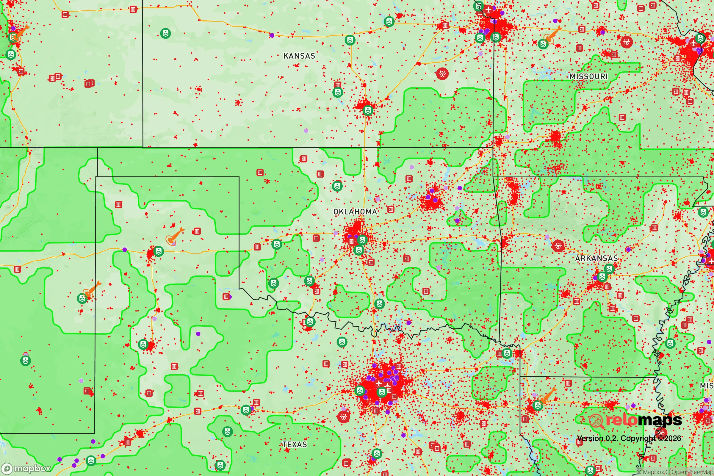
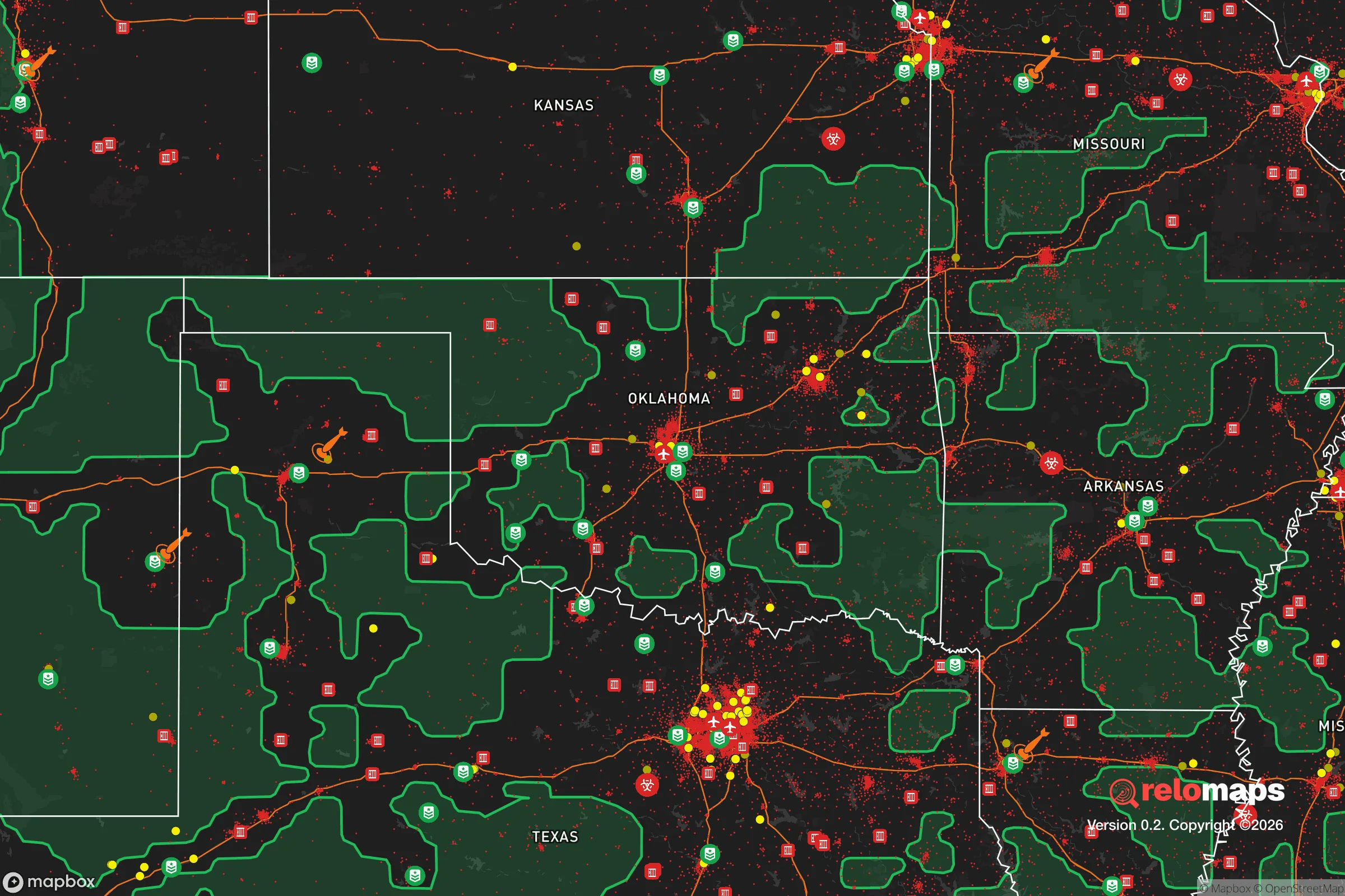
Important Note: For informational purposes only. This does not mean nothing bad ever happens in the green zones. Please use common sense. This is based on public data and modeled with AI. We tried to take a conservative approach but mistakes happen. We update this regularly as new information becomes available.
Solar Generator Recommendations
Backup power matters more here than in safer locations. We've picked three solar generators across budgets and capacity tiers — start with the budget unit if you only need a few essentials, or step up if you want to run a fridge and HVAC for days at a time.

Jackery Portable Power Station Explorer 300
Budget OptionPower on the Go: Weighing only 11 lbs, it's convenient to set up and store with book-sized foldable solar panels

BLUETTI Portable Power Station AC180
Designed for both indoor and outdoor scenarios, AC180 is highly capable as it has a robost capacity and continuous output power.

EF ECOFLOW DELTA Pro Ultra Power Station
Upgraded PickEcoFlow DELTA Pro Ultra is a whole-home energy system designed to grow with your family. Integrated with the Smart Home Panel 2, it scales to meet your evolving energy needs — keeping your home powered, intelligent, and secure through every stage of life.
We earn a commission, at no additional cost to you.
Strategic Assessment Analysis
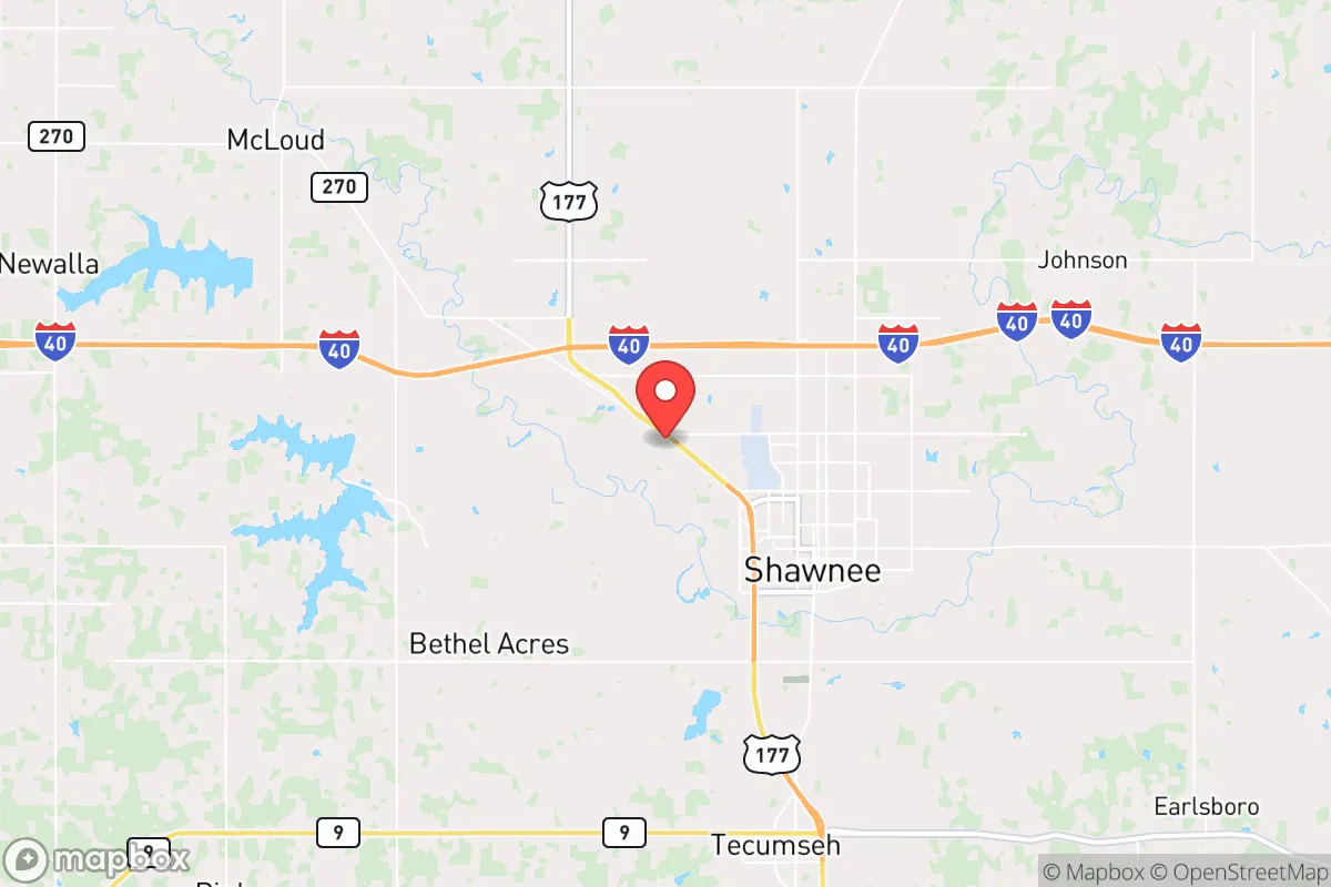
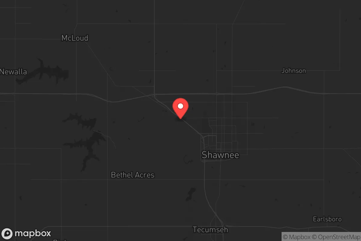
Shawnee, Oklahoma sits in a sweet spot that resilience-minded relocators rarely find: close enough to a major metro to access resources, far enough to avoid the blast radius when things go sideways. This city of roughly 32,000, located about 35 miles east of Oklahoma City along I-40, offers a strategic buffer that many preppers overlook. The area’s combination of agricultural land, water access, and low population density makes it a viable base for those planning to weather civic unrest, economic collapse, or natural disasters—provided you understand both its strengths and its genuine vulnerabilities.
Geographic position and natural advantages for long-term survival
Shawnee’s location is its primary strategic asset. It sits on the southern edge of the Cross Timbers region, a transitional zone between the prairies to the west and the forests to the east. This means the land is arable—good for gardening, livestock, and food production—without being as flood-prone as areas closer to the Red River. The North Canadian River runs just north of town, and several smaller creeks (like Deer Creek and Little River) provide surface water sources that can be developed with proper filtration. The water table here is generally reliable for wells, with most residential lots in the surrounding county (Pottawatomie) capable of producing 10–30 gallons per minute at depths of 100–200 feet. That’s a critical advantage if municipal water systems fail.
The terrain is gently rolling, not mountainous, which means you won’t have the defensibility of a ridge-top retreat. But it also means you’re not trapped in a valley. Multiple egress routes exist: I-40 east-west, US-177 north-south, and a network of county roads that can bypass choke points. For a relocator, this is a double-edged sword—easy to leave, but also easy for others to enter. The key is to secure a property with a single access point or natural barriers like creeks or tree lines. The area’s moderate climate (hot summers, cold winters, average 36 inches of rain per year) supports year-round growing seasons for cool-weather crops, though you’ll need irrigation for July and August.
Risks, exposures, and proximity to fallout-relevant landmarks
No location is perfect, and Shawnee has real exposures that a survivalist must weigh. The most obvious is its proximity to Tinker Air Force Base, located about 25 miles west in Midwest City. Tinker is a major maintenance and logistics hub for the US Air Force, including the E-3 AWACS fleet and the 552nd Air Control Wing. In a major conflict or nuclear exchange, Tinker is a high-value target. The prevailing winds in Oklahoma blow from the south and southwest, meaning fallout from a strike on Tinker would likely drift northeast—away from Shawnee in most scenarios, but not guaranteed. A ground burst at Tinker could produce fallout that reaches Shawnee within 2–4 hours depending on wind speed. You need a basement or a below-ground shelter if you’re within 50 miles of any military installation. Shawnee is inside that radius.
Other risks are more mundane but equally serious. Tornadoes are a fact of life here. Pottawatomie County averages 4–5 tornado warnings per year, and the May 2013 Moore tornado (EF5) was only 40 miles away. Mobile homes and stick-built houses without storm shelters are a liability. The area also sits near the Wilzetta Fault, a minor seismic zone that produced a 5.6 magnitude earthquake in Prague (20 miles east) in 2011. Not a dealbreaker, but it means your water well and septic system need to be built to code. On the human threat side, Shawnee has a small but active gang presence (primarily Sureños and Crips, per local law enforcement reports), and property crime rates are slightly above the national average. This isn’t a war zone, but it’s not a gated community either. You need perimeter security—motion lights, cameras, and a dog—especially if you’re on the outskirts.
Practical resilience for a relocator: food, water, energy, and defensibility
For a relocator serious about self-sufficiency, Shawnee offers a workable foundation. The local economy is anchored by agriculture (wheat, cattle, soybeans) and light manufacturing (including a large Tinker subcontractor presence). That means you can buy bulk grain, livestock feed, and hardware supplies locally without driving to Oklahoma City. The Pottawatomie County Extension Office offers soil testing and Master Gardener programs—free resources for building a food forest or permaculture setup. The growing season runs from April to October, with a last frost around April 10 and first frost around October 25. You can produce a significant portion of your calories on 1–2 acres with intensive gardening, plus raise chickens, goats, or rabbits for protein. Deer hunting is permitted on public land in the nearby Okmulgee Wildlife Management Area (about 30 minutes east), and fishing in the North Canadian is viable for catfish and crappie.
Energy resilience is more challenging. The local grid is served by OG&E, which has a mixed record during ice storms (the February 2021 winter storm left parts of Shawnee without power for 5–7 days). Solar is viable—the area averages 5.2 peak sun hours per day—but you’ll need battery storage and a generator backup for winter. Natural gas is available in town, but rural properties rely on propane. Wood heating is an option if you have acreage with hardwood trees (oak, hickory, cedar are common). Water storage is straightforward: install a 1,000–2,500 gallon cistern for rainwater catchment off your roof, plus a hand pump for your well. The water table is shallow enough that a manual pump can work in an emergency. Defensibility depends on your specific property. The ideal setup is a 5–20 acre parcel with a creek on one side, a tree line on another, and a single gravel driveway. Avoid properties with multiple road frontages or shared driveways. The local sheriff’s office is understaffed (about 40 deputies for the county), so response times in rural areas can exceed 30 minutes. You are your own first responder here.
The overall strategic picture for Shawnee is one of calculated trade-offs. It’s not a remote bunker in the Rockies, and it’s not a fortified compound in the Ozarks. What it offers is a middle ground: affordable land (average $3,000–$6,000 per acre for raw land, well below national averages), access to a major metro’s medical and supply infrastructure (OU Medical Center in OKC is 40 minutes away), and a community that is politically and culturally aligned with conservative values (Pottawatomie County voted +38 R in 2024). The downsides—proximity to Tinker, tornado risk, moderate crime—are manageable with planning. If you’re looking for a place to build a resilient life that can absorb shocks without requiring you to live off-grid in a cave, Shawnee deserves a serious look. Just dig that storm shelter before you need it, and keep your bug-out bag pointed east.
* Values derived from national, state, county, city and local statistics and may differ in a specific area. Last updated: 2026-04-21T11:43:26.000Z
Narrative content on this page is AI-generated and may contain mistakes. Verify any details that matter before acting on them.
ReloMaps may earn a commission from affiliate links at no extra cost to you.