Photo: Wikipedia
Strategic Assessment of South Padre Island, TX
Meaningful friction. Expect exposure to either population pressure, blast zones, or natural disaster risk. Consider buying a retreat property.
What does the Strategic Assessment tell us?
Our Strategic Assessment grades tactical survivability of an area. Major population centers, military targets, fallout zones, natural disasters, and border exposure all drive risk — lower exposure means a more defensible position in a crisis.
This is heavily inspired by Joel Skousen's Strategic Relocation book. Highly recommended you checkout the book ($)What does this tell us?
Our Strategic Assessment grades tactical survivability of an area. Major population centers, military targets, fallout zones, natural disasters, and border exposure all drive risk — lower exposure means a more defensible position in a crisis.
This is heavily inspired by Joel Skousen's Strategic Relocation book. Highly recommended you checkout the book ($)Strategic Pillars

Key Distances
Regional Safe Places
Below is our recommended "safe zones" in Texas and the surrounding area based on our strategic heuristics. For most people, it's unrealistic to live in a “safe zone” full-time due to work, family or other personal reasons. They tend to be more rural. However, many of these areas are perfect for second homes and retreat properties that double as a vacation home or even a short-term rental.


Important Note: For informational purposes only. This does not mean nothing bad ever happens in the green zones. Please use common sense. This is based on public data and modeled with AI. We tried to take a conservative approach but mistakes happen. We update this regularly as new information becomes available.
Solar Generator Recommendations
Backup power matters more here than in safer locations. We've picked three solar generators across budgets and capacity tiers — start with the budget unit if you only need a few essentials, or step up if you want to run a fridge and HVAC for days at a time.

Jackery Portable Power Station Explorer 300
Budget OptionPower on the Go: Weighing only 11 lbs, it's convenient to set up and store with book-sized foldable solar panels

BLUETTI Portable Power Station AC180
Designed for both indoor and outdoor scenarios, AC180 is highly capable as it has a robost capacity and continuous output power.

EF ECOFLOW DELTA Pro Ultra Power Station
Upgraded PickEcoFlow DELTA Pro Ultra is a whole-home energy system designed to grow with your family. Integrated with the Smart Home Panel 2, it scales to meet your evolving energy needs — keeping your home powered, intelligent, and secure through every stage of life.
We earn a commission, at no additional cost to you.
Strategic Assessment Analysis
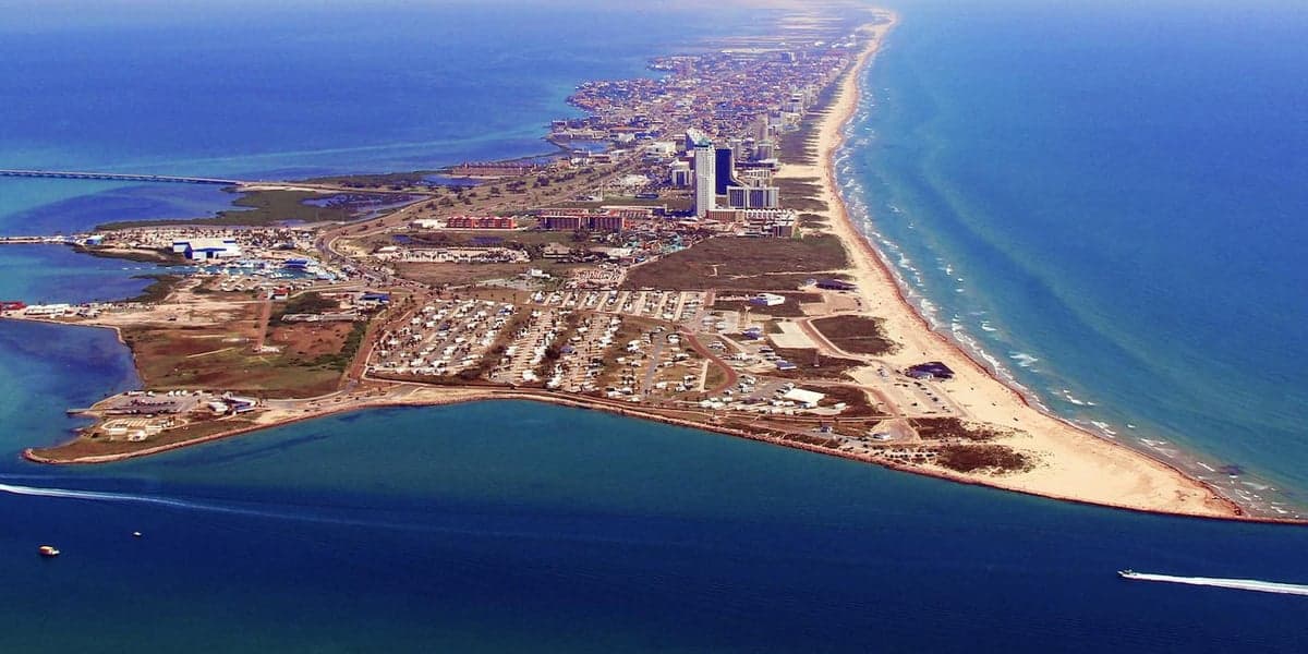
South Padre Island, Texas, presents a complex strategic picture for the conservative prepper or survivalist. Its primary advantage is extreme geographic isolation—a 34-mile barrier island connected to the mainland by a single causeway—which offers natural defensibility and distance from major population centers. However, this isolation is a double-edged sword, creating a single-point-of-failure evacuation route and placing the island directly in the path of Gulf hurricanes. For a relocator prioritizing resilience over convenience, the island offers a unique mix of low-density living, strong community ties, and proximity to the Rio Grande Valley’s agricultural resources, but it demands serious contingency planning for weather events and supply chain disruptions.
Geographic position and natural advantages for long-term security
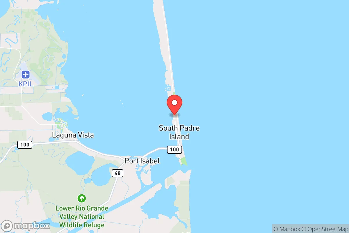
South Padre Island’s location at the southern tip of Texas, roughly 25 miles from the Mexican border, provides a buffer from the chaos of larger metros like Houston (350 miles north) and San Antonio (300 miles northwest). The island itself is narrow—less than a mile wide in most spots—meaning you’re never far from the Gulf of Mexico or the Laguna Madre Bay, which offers a secondary water source and potential fishing grounds. The surrounding Lower Rio Grande Valley is one of the most productive agricultural regions in the United States, with year-round growing seasons and abundant citrus, sugarcane, and vegetable farms within a 30-minute drive on the mainland. This proximity to food production is a major resilience asset, especially if national supply chains falter. The area’s low population density—roughly 2,800 year-round residents on the island, swelling to 50,000+ during peak tourist season—means that during off-peak months, you have a small, tight-knit community where neighbors know each other and local governance is accessible. The subtropical climate also eliminates the risk of winter storms and freeze-related infrastructure failures, a growing concern for preppers in northern states.
Risks, exposures, and proximity to fallout-relevant landmarks
The island’s most glaring vulnerability is its single causeway (Queen Isabella Memorial Bridge) connecting it to Port Isabel on the mainland. In the event of a mandatory evacuation for a hurricane—which happens roughly every 3-5 years—this bridge becomes a choke point, with traffic jams extending for hours. A major storm could also damage or destroy the bridge, effectively trapping residents on the island for days or weeks. Beyond weather, the island’s proximity to the Mexican border (about 30 miles from Matamoros) introduces risks of cartel-related violence spillover, though this is more of a concern for the mainland border towns than the island itself. The Port of Brownsville, located 25 miles west, is a major industrial hub for liquefied natural gas (LNG) exports and shipping, making it a potential target for sabotage or disruption during a national crisis. The nearby SpaceX facility at Boca Chica (20 miles up the coast) is another high-profile asset that could draw unwanted attention. For the survivalist, these are not immediate threats but factors to monitor—any major incident at the port or spaceport could trigger a cascade of security responses that affect the island’s isolation. The area also sits in a designated hurricane zone, with storm surge risks of 10-15 feet in a Category 3+ event, meaning any long-term structure must be built to elevated standards.
Practical resilience for a relocator: food, water, energy, and defensibility
For a relocator setting up a resilient homestead, South Padre Island offers both opportunities and hard constraints. Water is the most critical issue: the island relies entirely on a mainland water pipeline from the Brownsville Public Utilities Board. In a prolonged grid-down scenario, you’d need a private well (difficult on a sand barrier island) or a robust rainwater catchment system—average annual rainfall is only 26 inches, so storage capacity must be generous. Desalination is technically feasible given the surrounding saltwater, but small-scale units are expensive and energy-intensive. Food security is more promising: the Rio Grande Valley’s farms are a 20-minute drive, and the Laguna Madre Bay offers year-round fishing for redfish, trout, and flounder. Hunting is limited on the island itself (mostly migratory birds), but the mainland has white-tailed deer and feral hogs. Energy resilience is mixed: the island gets plenty of sun (over 300 sunny days per year), making solar panels a viable primary or backup power source. However, the grid is vulnerable to hurricane damage, and natural gas delivery for generators could be disrupted. Many locals already run propane generators, and building codes require elevated structures, which also provide natural ventilation and passive cooling. Defensibility is the island’s strongest card: the single causeway creates a natural chokepoint that could be monitored or controlled by a small group. The island’s layout—long, narrow, with limited entry points—makes it easy to observe approaching threats. The local police force is small (about 30 officers), but the community is tight-knit and armed—Texas’s constitutional carry laws apply, and gun ownership rates in Cameron County are above the national average. For a single individual or family, the island offers a low-profile lifestyle where you can keep to yourself while still having access to a small grocery store, hardware store, and medical clinic (the nearest hospital is 30 minutes away in Harlingen).
The overall strategic picture for South Padre Island is one of trade-offs. It is not a bug-out location for a sudden national collapse—the hurricane risk and single causeway make it a potential trap in a fast-moving crisis. But for a long-term, slow-burn scenario—economic instability, supply chain disruptions, localized unrest—the island’s isolation, agricultural proximity, and defensible geography make it a viable option for the conservative prepper who values self-reliance over convenience. The key is to treat the island as a base of operations rather than a fortress: maintain a mainland cache of supplies and a secondary vehicle, invest in solar and rainwater systems, and build relationships with local farmers and fishermen. If you can weather the hurricane season and accept the trade-off of being far from major medical and logistical hubs, South Padre Island offers a quiet, low-risk environment for riding out the storm—as long as you’re not on the bridge when it hits.
* Values derived from national, state, county, city and local statistics and may differ in a specific area. Last updated: 2026-04-15T06:31:11.000Z
Narrative content on this page is AI-generated and may contain mistakes. Verify any details that matter before acting on them.
ReloMaps may earn a commission from affiliate links at no extra cost to you.