
Photo: Wikipedia
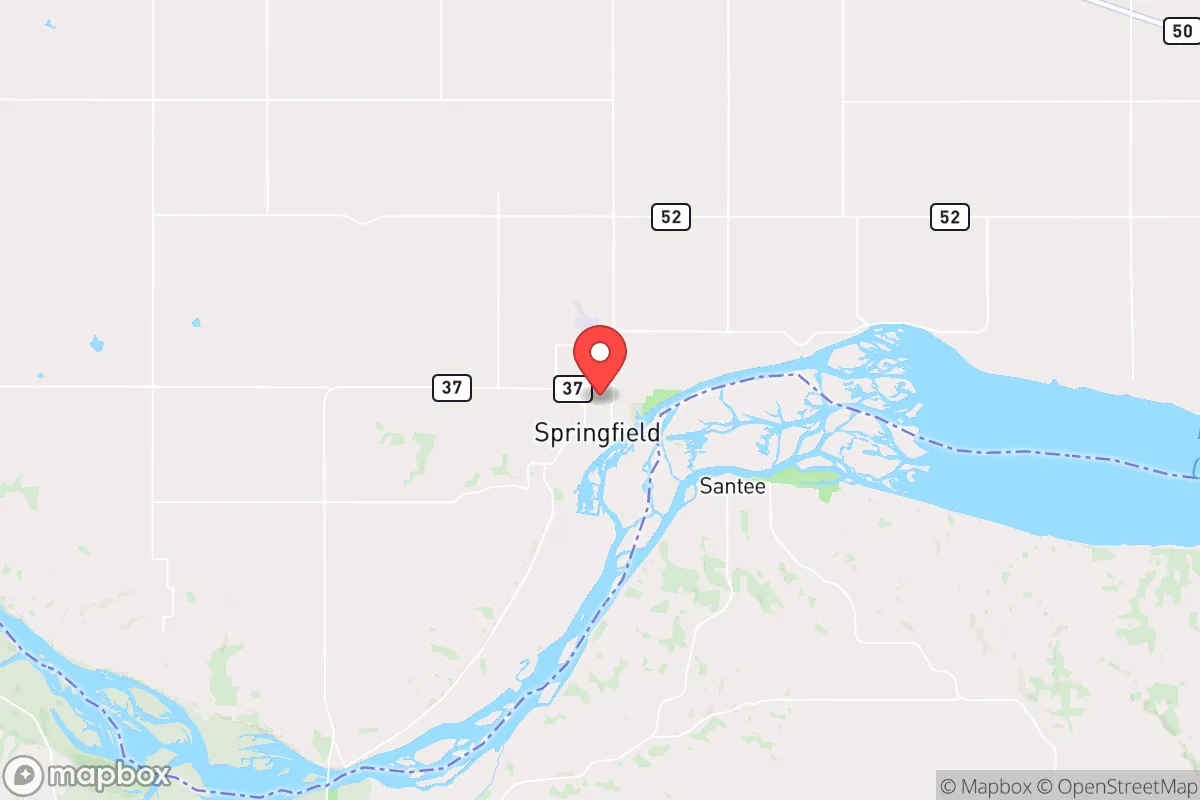
Strategic Assessment of Springfield, SD
Strong survivability profile. Good buffer from population centers, with manageable environmental and tactical risks.
What does the Strategic Assessment tell us?
Our Strategic Assessment grades tactical survivability of an area. Major population centers, military targets, fallout zones, natural disasters, and border exposure all drive risk — lower exposure means a more defensible position in a crisis.
This is heavily inspired by Joel Skousen's Strategic Relocation book. Highly recommended you checkout the book ($)What does this tell us?
Our Strategic Assessment grades tactical survivability of an area. Major population centers, military targets, fallout zones, natural disasters, and border exposure all drive risk — lower exposure means a more defensible position in a crisis.
This is heavily inspired by Joel Skousen's Strategic Relocation book. Highly recommended you checkout the book ($)Strategic Pillars

Key Distances
Regional Safe Places
Below is our recommended "safe zones" in South Dakota and the surrounding area based on our strategic heuristics. For most people, it's unrealistic to live in a “safe zone” full-time due to work, family or other personal reasons. They tend to be more rural. However, many of these areas are perfect for second homes and retreat properties that double as a vacation home or even a short-term rental.


Important Note: For informational purposes only. This does not mean nothing bad ever happens in the green zones. Please use common sense. This is based on public data and modeled with AI. We tried to take a conservative approach but mistakes happen. We update this regularly as new information becomes available.
Solar Generator Recommendations
Backup power matters more here than in safer locations. We've picked three solar generators across budgets and capacity tiers — start with the budget unit if you only need a few essentials, or step up if you want to run a fridge and HVAC for days at a time.

Jackery Portable Power Station Explorer 300
Budget OptionPower on the Go: Weighing only 11 lbs, it's convenient to set up and store with book-sized foldable solar panels

BLUETTI Portable Power Station AC180
Designed for both indoor and outdoor scenarios, AC180 is highly capable as it has a robost capacity and continuous output power.

EF ECOFLOW DELTA Pro Ultra Power Station
Upgraded PickEcoFlow DELTA Pro Ultra is a whole-home energy system designed to grow with your family. Integrated with the Smart Home Panel 2, it scales to meet your evolving energy needs — keeping your home powered, intelligent, and secure through every stage of life.
We earn a commission, at no additional cost to you.
Strategic Assessment Analysis
Springfield, South Dakota, offers a strategic relocation option for those prioritizing resilience, self-sufficiency, and distance from major population centers. Located in Bon Homme County in the southeastern part of the state, this small town of roughly 1,500 people sits on the Missouri River, providing a critical water resource and a natural buffer against the chaos of urban collapse. Its position—far from the major interstate corridors, yet within a reasonable drive of Sioux Falls (about 90 miles) and Yankton (about 30 miles)—strikes a balance between isolation and access to necessary supplies when the grid holds. For the conservative-minded prepper, Springfield represents a low-profile, defensible location with a strong agricultural base and a community that still values self-reliance.
Geographic position and natural advantages for long-term security
Springfield’s primary strategic asset is its location on the Missouri River, a reliable, year-round water source that is a non-negotiable for any long-term survival scenario. The town sits on a bluff overlooking the river, offering elevated ground that provides natural defensibility and good drainage—important for avoiding flood risks while still having direct river access. The surrounding Bon Homme County is overwhelmingly agricultural, with vast stretches of corn, soybeans, and pastureland. This means local food production is not a theoretical exercise; it’s the economic backbone. For a relocator, this translates to direct access to local farmers, ranchers, and the possibility of bartering or purchasing bulk staples without relying on fragile supply chains. The area is also within the Missouri River flyway, offering ample hunting opportunities for deer, waterfowl, and small game, which supplements food security. The climate is continental—cold winters and hot summers—but the growing season (roughly 150 days) is sufficient for a serious garden, especially with cold frames or a greenhouse. The low population density (about 7 people per square mile in the county) means that in a grid-down scenario, you are not competing with millions for resources. You are competing with a few thousand, and most of them already know how to produce their own food.
Risks, exposures, and proximity to fallout-relevant landmarks
No location is perfect, and Springfield has its vulnerabilities. The most significant risk is its proximity to the Missouri River dams—specifically the Fort Randall Dam (about 25 miles upstream) and the Gavins Point Dam (about 30 miles downstream). In a major seismic event or a targeted attack on critical infrastructure, a dam failure could cause catastrophic flooding along the river corridor. While Springfield sits on a bluff, the low-lying areas near the river and the town’s water intake infrastructure could be compromised. Additionally, the Yankton area, just 30 miles north, is home to the Yankton Federal Prison Camp and a significant National Guard presence. In a civil unrest scenario, this could become a focal point for federal activity or a target for destabilization. The Sioux Falls metro, while not a direct fallout zone, is a major population center (over 260,000 people) and a regional hub for healthcare, logistics, and the military (the 114th Fighter Wing is based there). In a mass casualty event or a breakdown of order, you can expect a significant outflow of people from Sioux Falls heading south and west along Highway 81 and Highway 50—both of which pass near Springfield. This means the town could see a surge of refugees, which is a security concern. There are no major nuclear power plants within a 100-mile radius, but the Ellsworth Air Force Base near Rapid City (about 250 miles west) is a primary strategic target. Fallout from a strike there would likely be carried east by prevailing winds, but Springfield is far enough to avoid lethal deposition unless the wind shifts dramatically. The Fort Calhoun Nuclear Station in Nebraska is about 100 miles southeast—a moderate risk, but not a primary concern.
Practical resilience for a relocator: food, water, energy, and defensibility
For a single individual or a family looking to establish a resilient homestead, Springfield offers a practical foundation. Water security is the strongest asset: the Missouri River is a massive, unfilterable source, but you will need a reliable pump (solar or hand-operated) and a filtration system (Berkey or similar) to make it potable. The town’s municipal water comes from the river, so in a grid-down scenario, the treatment plant will fail. A well is the gold standard, but drilling in the river valley can be expensive and may yield high mineral content. Food security is excellent: the county has multiple grain elevators, local meat processors, and a strong network of small-scale farmers. You can buy a 50-pound bag of wheat or corn directly from a local co-op for a fraction of supermarket prices. The Springfield Farmers Market operates seasonally, and there are several U-pick orchards within a 20-mile radius. For long-term storage, the dry climate (average humidity around 65%) is better than the Deep South but still requires proper sealing to prevent mold. Energy resilience is a mixed bag. The area is served by Bon Homme Yankton Electric Association, a cooperative that is generally reliable, but rural co-ops are often the first to be deprioritized in a regional blackout. Solar is viable—the area gets about 210 sunny days per year—but winter cloud cover can be persistent. A backup generator with a 500-gallon propane tank is a wise investment. Defensibility is good for a small town: the layout is compact, with a few main roads (Highway 37 and Highway 50) that can be monitored. The surrounding farmland offers clear sightlines, and the river bluffs provide natural chokepoints. However, the town itself is not walled or gated; security will depend on neighborhood mutual aid and your own perimeter planning. The local Bon Homme County Sheriff’s Office is small (about 5 deputies on duty at peak), so in a crisis, you are largely on your own. The nearest hospital is in Yankton (30 minutes), which is a vulnerability for medical emergencies during a disaster.
The overall strategic picture for Springfield is one of moderate-to-high resilience with specific, manageable risks. It is not a remote mountain redoubt, but it is far enough from major targets to avoid the initial shockwave of a national crisis. The Missouri River water supply, the agricultural abundance, and the low population density make it a viable location for a self-sufficient lifestyle. The primary downsides are the dam-related flood risk)Skip and the potential for refugee flow from Sioux Falls and Yankton. For a conservative-leaning relocator who values community, local food production, and a quiet life away from the chaos of the coasts, Springfield offers a solid foundation. It is a place where you can dig in, build relationships with neighbors who share your values, and ride out the storm—provided you have your own water filtration, a well-stocked pantry, and a plan for the first 72 hours of any event. The key is to treat it as a base of operations, not a fortress. The land and the river will sustain you, but only if you put in the work before the lights go out.
* Values derived from national, state, county, city and local statistics and may differ in a specific area. Last updated: 2026-05-01T05:54:21.000Z
Narrative content on this page is AI-generated and may contain mistakes. Verify any details that matter before acting on them.
ReloMaps may earn a commission from affiliate links at no extra cost to you.