Photo: Wikipedia
Strategic Assessment of Cooke County
Workable tactical position. Some exposure to population density or targets, but generally defensible in a crisis.
What does the Strategic Assessment tell us?
Our Strategic Assessment grades tactical survivability of an area. Major population centers, military targets, fallout zones, natural disasters, and border exposure all drive risk — lower exposure means a more defensible position in a crisis.
This is heavily inspired by Joel Skousen's Strategic Relocation book. Highly recommended you checkout the book ($)What does this tell us?
Our Strategic Assessment grades tactical survivability of an area. Major population centers, military targets, fallout zones, natural disasters, and border exposure all drive risk — lower exposure means a more defensible position in a crisis.
This is heavily inspired by Joel Skousen's Strategic Relocation book. Highly recommended you checkout the book ($)Strategic Pillars

Key Distances
Strategic Assessment Analysis
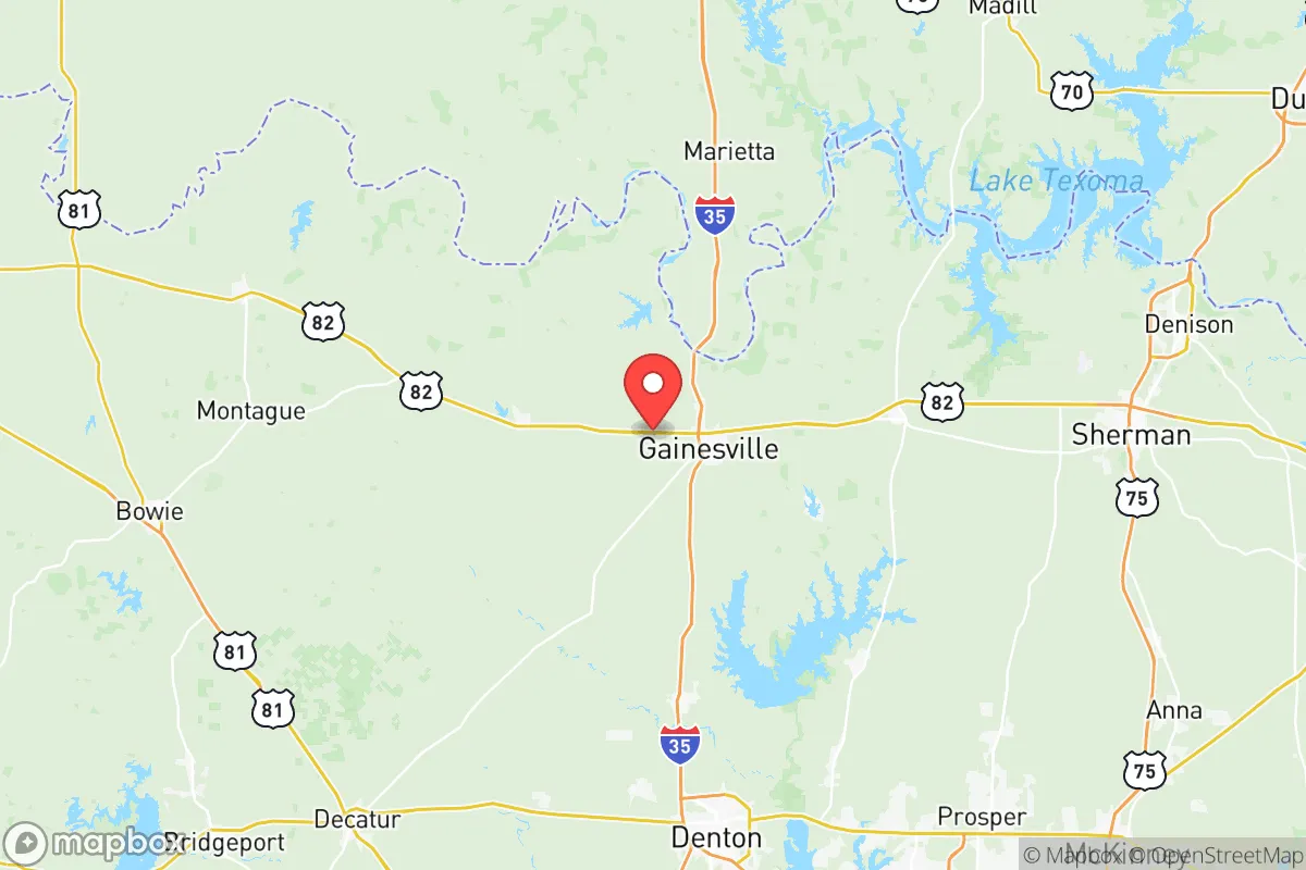
Cooke County, Texas, offers a compelling strategic position for those prioritizing resilience and self-sufficiency in an uncertain future. Anchored by the city of Gainesville, the county sits roughly 60 miles north of the Dallas-Fort Worth metroplex—close enough to access resources but far enough to avoid the immediate fallout of a major urban crisis. Its location along Interstate 35 provides a critical north-south corridor, while the Red River forms a natural boundary to the north, separating Texas from Oklahoma. This combination of highway access, river defense, and distance from major population centers makes Cooke County a serious contender for anyone evaluating relocation through a prepper or survivalist lens.
Geographic position and natural advantages for long-term security
Cooke County’s geography is defined by its position on the eastern edge of the North Texas plains, with rolling hills, scattered woodlands, and the Red River Valley to the north. The county’s 874 square miles offer a mix of agricultural land, ranch properties, and small towns like Muenster, Lindsay, and Valley View. This low population density—roughly 41,000 residents as of 2025—means fewer people competing for resources in a crisis. The Red River itself is a double-edged asset: it provides a natural barrier against northward threats, but its floodplain requires careful site selection. The county’s elevation averages around 750 feet, reducing risks from storm surge or sea-level rise, and the local climate supports dryland farming without heavy reliance on irrigation. For a relocator, the key advantage is defensible space—the ability to choose a property with clear sightlines, multiple egress routes, and minimal neighbors within a mile.
Risks, exposures, and proximity to fallout-relevant landmarks
No strategic assessment is honest without addressing vulnerabilities. Cooke County’s primary risk is its proximity to the Dallas-Fort Worth metroplex, a population center of over 7.5 million people. In a major civic unrest scenario, I-35 could become a chokepoint for refugees fleeing south, and the county’s position as a transit corridor means it would see heavy traffic. The county also sits within 100 miles of several high-value targets: the Fort Cavazos (formerly Fort Hood) military installation to the south, the DFW International Airport to the southeast, and the Pantex nuclear weapons plant near Amarillo to the northwest—roughly 200 miles away but within fallout drift range under certain wind patterns. Closer to home, the Gainesville Municipal Airport and the Texas-New Mexico Power plant in the county are minor infrastructure points but unlikely to be primary targets. The real concern is fallout from a major event at Pantex or a refinery in the Houston corridor, though prevailing winds typically blow west-to-east, which would carry contamination away from Cooke County. Flooding along the Red River and its tributaries is the most immediate natural risk, with the Elm Fork of the Trinity River also running through the county’s southern edge. Property buyers should avoid low-lying areas near these waterways.
Practical resilience for a relocator: food, water, energy, and defensibility
For a family or individual serious about self-sufficiency, Cooke County delivers on the basics. Water access is the strongest asset: the county sits atop the Trinity Aquifer, and many rural properties can drill wells at depths of 200-400 feet with reliable yields. Surface water from the Red River and area lakes—like Lake Ray Roberts just south in Denton County—provides backup, though treatment would be necessary. Agricultural land is affordable, with raw acreage running $3,000-$6,000 per acre as of 2025, and the growing season spans 230 days, supporting vegetables, grains, and livestock. The county has a strong ranching culture, meaning local knowledge and supply chains for fencing, feed, and veterinary care are readily available. Energy resilience is moderate: the grid is served by the Electric Reliability Council of Texas (ERCOT), which has a history of winter storm failures. Solar with battery backup is a wise investment, and natural gas wells are present in the county, offering potential for off-grid heating. Defensibility varies by property: the open plains offer long sightlines but limited cover, while the wooded areas near the Red River provide concealment. Gainesville is the county seat and a logical hub for supplies, with a Walmart, a regional hospital, and multiple feed stores. For a prepper, the ideal setup is a rural property with a well, solar panels, a root cellar, and at least two vehicle-accessible routes out of the county—preferably one heading west toward the less-populated Panhandle.
The overall strategic picture for Cooke County is one of balanced opportunity and calculated risk. It avoids the extreme exposure of border counties or those near major military bases, while still offering access to urban markets for work or trade. The conservative political culture—Cooke County voted +38 Republican in the 2024 presidential election—aligns with a self-reliance mindset, and local gun culture is strong, with multiple shooting ranges and a county sheriff’s office that publicly supports Second Amendment rights. The downsides are real: the I-35 corridor is a vulnerability, and the county’s agricultural economy could be disrupted by prolonged drought or supply chain failures. But for a relocator who values space, water security, and a like-minded community, Cooke County ranks as a solid B+ option—not the most remote, but far more practical than deep rural areas with no infrastructure. The key is to buy land with a well and a defensible position, build relationships with neighbors early, and keep a vehicle fueled for a potential southern exit if the metroplex collapses northward. In a world of increasing uncertainty, Cooke County offers a place to stand—not a fortress, but a foundation.
* Values derived from national, state, county, city and local statistics and may differ in a specific area. Last updated: 2026-05-21T10:23:16.000Z
Narrative content on this page is AI-generated and may contain mistakes. Verify any details that matter before acting on them.
ReloMaps may earn a commission from affiliate links at no extra cost to you.