Photo: Wikipedia
Strategic Assessment of Fannin County
Workable tactical position. Some exposure to population density or targets, but generally defensible in a crisis.
What does the Strategic Assessment tell us?
Our Strategic Assessment grades tactical survivability of an area. Major population centers, military targets, fallout zones, natural disasters, and border exposure all drive risk — lower exposure means a more defensible position in a crisis.
This is heavily inspired by Joel Skousen's Strategic Relocation book. Highly recommended you checkout the book ($)What does this tell us?
Our Strategic Assessment grades tactical survivability of an area. Major population centers, military targets, fallout zones, natural disasters, and border exposure all drive risk — lower exposure means a more defensible position in a crisis.
This is heavily inspired by Joel Skousen's Strategic Relocation book. Highly recommended you checkout the book ($)Strategic Pillars

Key Distances
Strategic Assessment Analysis
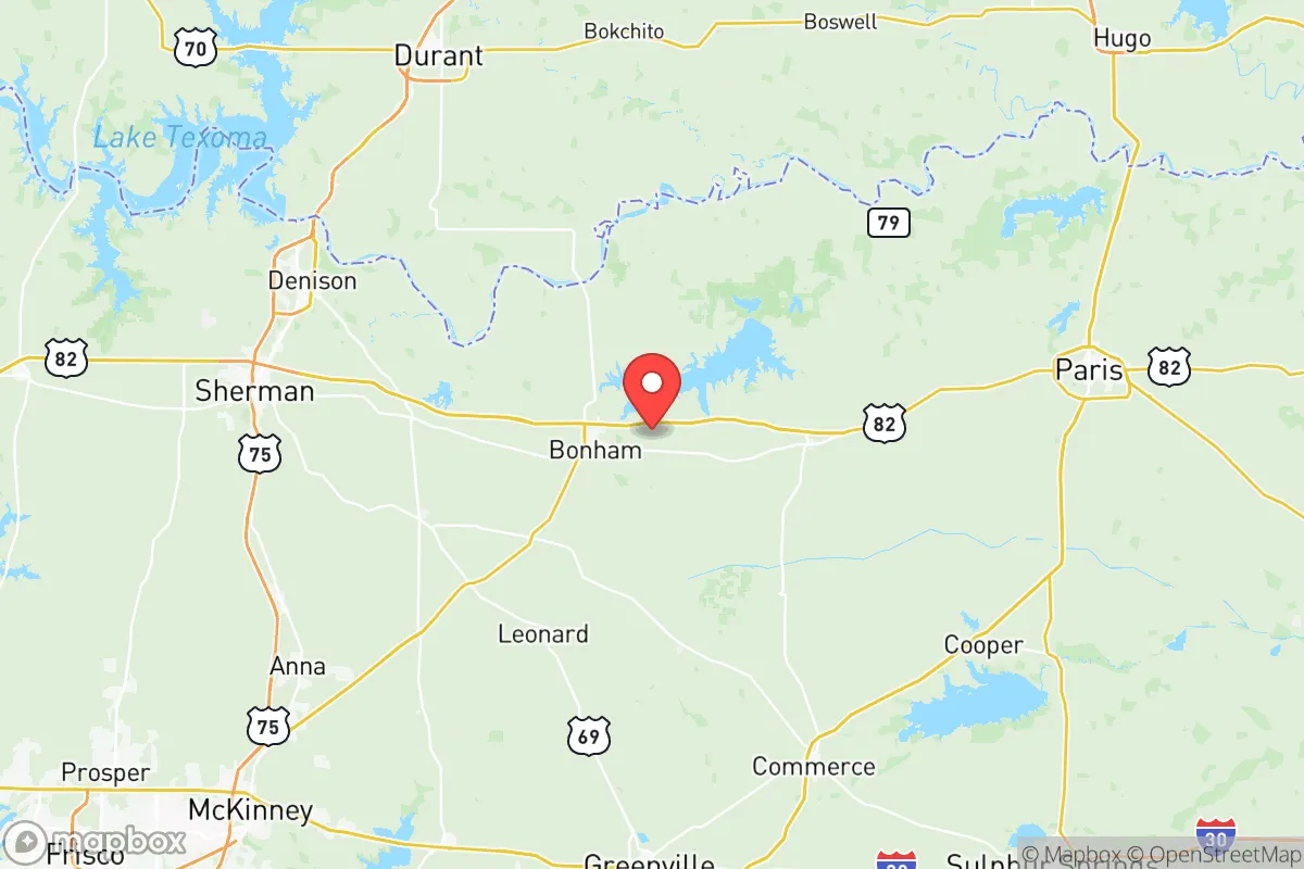
Fannin County offers a rare combination of agricultural self-sufficiency, low population density, and strategic positioning that puts it on the short list for anyone serious about long-term resilience. Sitting about 65 miles northeast of Dallas, it's far enough from the metroplex to avoid the worst of any urban collapse scenario, yet close enough that a pre-relocation supply run or a post-event recon mission isn't out of the question. The county's 35,000 residents spread across roughly 900 square miles give you a density figure—roughly 39 people per square mile—that translates to real breathing room when things go sideways.
Geographic position and natural advantages that matter when the lights go out
Fannin County sits on the southern bank of the Red River, giving it a defined northern border that acts as a natural chokepoint and potential defensible line. The county's terrain transitions from the Blackland Prairie in the south to the Eastern Cross Timbers in the north, offering a mix of open grazing land and wooded ridgelines that provide both agricultural space and cover. The newly filled Bois d'Arc Lake, completed in 2021, is a game-changer—it's the first major reservoir built in Texas in decades and gives the county a dedicated, independently managed water source that isn't tied to the aging Dallas water grid. Lake Fannin, a smaller impoundment south of Bonham, adds redundancy. For a relocator thinking about water independence, having two separate lake systems within the county boundary is a concrete advantage that many rural Texas counties cannot match. The Caddo National Grassland, which spills into the county's eastern edge, provides public-access timber, wildlife, and a buffer zone that makes neighbor-to-neighbor distances even greater. From a strategic standpoint, the county's position northeast of the Dallas-Fort Worth metroplex puts it upwind of prevailing weather patterns, meaning airborne fallout from an urban incident would most likely track east or northeast, not directly into Fannin. That's not a guarantee—nothing is in this line of work—but it's a directional edge worth noting.
Risks, exposures, and what's close enough to matter when things break bad
No honest assessment skips the liabilities, and Fannin County has a few that demand attention. The obvious one is distance to Dallas-Fort Worth—65 miles as the crow flies, which is inside the moderate fallout zone for a ground-level nuclear detonation and well within the civil unrest ripple radius from a major urban grid-down event. If the metroplex destabilizes, expect internal displacement westward along US-82 and southward along TX-121, both of which feed directly into Bonham and Leonard. The Comanche Peak Nuclear Power Plant, located roughly 100 miles southwest near Glen Rose, introduces a secondary risk vector. While 100 miles is outside the immediate evacuation zone, a major release under prevailing southerly winds could deposit contamination across the region. More proximate is Lake Texoma to the north, whose dam infrastructure and recreational traffic make it a chokepoint for anyone trying to move north into Oklahoma. The Red River itself poses a contamination pathway—if industrial failures upstream or a deliberate release poison the water, the county's northern boundary becomes a liability rather than an asset. Tornado risk is real here; Fannin sits on the southern edge of the traditional Dixie Alley corridor, and the flat-to-rolling terrain offers little natural deflection. A direct hit on Bonham or Honey Grove would stress local medical resources fast—the county has one hospital, TMC Bonham, which is adequate for routine care but not built for mass casualty triage.
Practical resilience for a relocator—food, water, energy, and defensibility
Food production is where Fannin County separates itself from more arid relocation spots in West Texas. The county's agricultural base is built on cattle, poultry, dairy, and row crops—corn, wheat, soybeans, and hay. That means local food supply isn't hypothetical; it's operational. The Bonham Livestock Auction runs weekly and is a regional hub for livestock trading, which matters if you need to barter for protein or offload surplus. For water, Bois d'Arc Lake is the headline asset—2,000 surface acres, fully online, managed by the Tarrant Regional Water District but physically located in Fannin County. That lake alone gives the county a water surplus that most of Texas cannot claim. Groundwater from the Trinity and Woodbine aquifers is accessible with a drilled well, though depths vary from 100 to 400 feet depending on location. Energy resilience is more mixed. Most of the county is served by CoServ Electric, a cooperative that's more reliable than investor-owned utilities, but the grid is still part of ERCOT and vulnerable to the same winter storm failures that nearly collapsed Texas in 2021. On-site solar paired with battery storage is viable here—the region gets roughly 210 sunny days per year—but anyone serious about winter resilience needs a generator or micro-hydro if they have flowing water on their property. Defensibility favors a rural homestead over a town lot. The terrain around Ladonia and Ivanhoe offers wooded ridges and creek bottoms that provide natural security and observation points. The county's low law enforcement density—roughly one deputy per 3,000 residents—means that security is ultimately your responsibility. Neighbor networks are active but insular; newcomers who invest in relationships before they need them will find that the community's agricultural cooperatives and volunteer fire departments function as informal mutual aid networks.
The strategic picture for Fannin County comes down to trade-offs. It is not a bug-out location for complete isolation—you are still within a day's drive of 7 million people, and that proximity carries risk. But for someone who wants to stay connected to the broader region while maintaining independent water, food, and energy systems, the county's combination of new reservoir capacity, established agricultural infrastructure, and moderate land prices makes it one of the more viable options in the eastern half of Texas. The key is to act before the next shock—land near reliable water, build soil before building structures, and treat the community as a resource rather than an obstacle. Fannin County rewards preparation and punishes passivity. That is the kind of place worth a hard look.
* Values derived from national, state, county, city and local statistics and may differ in a specific area. Last updated: 2026-06-03T03:40:20.000Z
Narrative content on this page is AI-generated and may contain mistakes. Verify any details that matter before acting on them.
ReloMaps may earn a commission from affiliate links at no extra cost to you.