Photo: Wikipedia
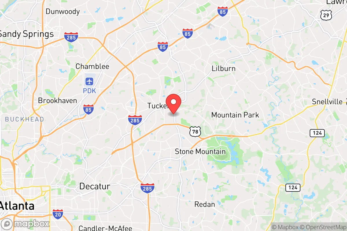
Strategic Assessment of Tucker, GA
Multiple tactical vulnerabilities. Population density, target proximity, or disaster risk are likely compounding. A retreat property and exit planning is required.
What does the Strategic Assessment tell us?
Our Strategic Assessment grades tactical survivability of an area. Major population centers, military targets, fallout zones, natural disasters, and border exposure all drive risk — lower exposure means a more defensible position in a crisis.
This is heavily inspired by Joel Skousen's Strategic Relocation book. Highly recommended you checkout the book ($)What does this tell us?
Our Strategic Assessment grades tactical survivability of an area. Major population centers, military targets, fallout zones, natural disasters, and border exposure all drive risk — lower exposure means a more defensible position in a crisis.
This is heavily inspired by Joel Skousen's Strategic Relocation book. Highly recommended you checkout the book ($)Strategic Pillars

Key Distances
Regional Safe Places
Below is our recommended "safe zones" in Georgia and the surrounding area based on our strategic heuristics. For most people, it's unrealistic to live in a “safe zone” full-time due to work, family or other personal reasons. They tend to be more rural. However, many of these areas are perfect for second homes and retreat properties that double as a vacation home or even a short-term rental.


Important Note: For informational purposes only. This does not mean nothing bad ever happens in the green zones. Please use common sense. This is based on public data and modeled with AI. We tried to take a conservative approach but mistakes happen. We update this regularly as new information becomes available.
Solar Generator Recommendations
Backup power matters more here than in safer locations. We've picked three solar generators across budgets and capacity tiers — start with the budget unit if you only need a few essentials, or step up if you want to run a fridge and HVAC for days at a time.

Jackery Portable Power Station Explorer 300
Budget OptionPower on the Go: Weighing only 11 lbs, it's convenient to set up and store with book-sized foldable solar panels

BLUETTI Portable Power Station AC180
Designed for both indoor and outdoor scenarios, AC180 is highly capable as it has a robost capacity and continuous output power.

EF ECOFLOW DELTA Pro Ultra Power Station
Upgraded PickEcoFlow DELTA Pro Ultra is a whole-home energy system designed to grow with your family. Integrated with the Smart Home Panel 2, it scales to meet your evolving energy needs — keeping your home powered, intelligent, and secure through every stage of life.
We earn a commission, at no additional cost to you.
Strategic Assessment Analysis
Tucker, Georgia, sits in a peculiar strategic pocket: close enough to Atlanta to access its resources, yet far enough to avoid the worst of the city’s collapse scenarios. Its resilience hinges on a mix of suburban sprawl, modest natural buffers, and a population density that offers both anonymity and community—if you know where to look. For a relocator with a prepper mindset, Tucker presents a trade-off: you gain proximity to supply chains and medical infrastructure, but you also inherit the fallout risks of a major metropolitan target. The key is whether you can leverage the area’s advantages without being trapped by its vulnerabilities.
Geographic position and natural advantages for long-term survival
Tucker’s location in DeKalb County, roughly 15 miles northeast of downtown Atlanta, places it in the Piedmont region—a landscape of rolling hills, clay soils, and mixed hardwood forests. This terrain offers natural defensibility: the hills provide observation points and limited cover, while the forests can serve as both concealment and a source of timber for fuel or construction. The area sits at an elevation around 1,000 feet, which reduces flood risk compared to low-lying parts of metro Atlanta. The nearby Chattahoochee River, about 10 miles west, is a reliable water source, though it’s also a potential contamination vector if upstream infrastructure fails. Tucker’s position along the Eastern Continental Divide means surface water drains away from the city, which can be a mixed blessing—less flood risk, but also less natural water retention. The climate is humid subtropical, with hot summers and mild winters, allowing for year-round gardening and outdoor activity. However, the region’s clay soils are poor for drainage and agriculture without significant amendment, so any long-term food production plan will require raised beds or imported topsoil. The area’s natural advantages are real but modest: you’re not in a mountain redoubt, but you’re also not in a floodplain. For a prepper, this means you can work with the land, but you’ll need to invest in soil improvement and water storage from day one.
Risks, exposures, and proximity to fallout-relevant landmarks
Tucker’s biggest strategic weakness is its proximity to Atlanta—a prime target for civil unrest, economic collapse, or a mass casualty event. The city is within the blast radius of any conventional or nuclear strike on downtown Atlanta, and fallout patterns from a detonation at Hartsfield-Jackson International Airport (20 miles south) or the Centers for Disease Control and Prevention (CDC) headquarters (10 miles west) could easily reach Tucker depending on wind direction. The CDC is a particularly sensitive landmark: in a pandemic or bioweapon scenario, it becomes a ground zero for both response and chaos. Tucker also sits near major transportation corridors—Interstate 285 (the Perimeter) and Highway 78—which are choke points for evacuation and supply routes. In a crisis, these roads will clog within hours, turning Tucker into a dead-end for anyone trying to leave. The area’s population density (roughly 2,500 people per square mile) means you’ll have neighbors close enough to hear gunfire but not close enough to form a cohesive defense without prior organization. There are no significant military bases or hardened government facilities nearby, which is a double-edged sword: less risk of being targeted, but also less chance of organized relief. The nearby Stone Mountain (15 miles east) is a notable landmark—its granite mass could offer some shielding from radiation, but it’s also a tourist attraction that would become a refugee magnet. For a prepper, the takeaway is clear: Tucker is not a retreat location. It’s a suburban buffer zone that requires a bug-out plan to more rural areas north or east, such as the North Georgia mountains or the South Carolina upcountry.
Practical resilience for a relocator: food, water, energy, and defensibility
For a single individual or family looking to hunker down in Tucker, practical resilience starts with water. The municipal supply comes from the Chattahoochee River via DeKalb County’s Scott Candler Water Treatment Plant, which is vulnerable to both contamination and power failure. A prepper should plan for at least two weeks of stored water (one gallon per person per day) plus a Berkey or similar gravity filter for rainwater collection. The area averages 50 inches of rain annually, so rainwater harvesting is viable, but you’ll need a large cistern and a first-flush diverter to handle roof debris. Food production is possible but labor-intensive: the growing season runs from April to October, and you can raise vegetables like tomatoes, peppers, and greens in raised beds. However, the clay soil and suburban lot sizes (typically 0.25 to 0.5 acres) limit yield. A more practical approach is to stockpile freeze-dried food and build relationships with local farmers at the Tucker Farmers Market (open year-round on Saturdays). Energy resilience is a weak point: Tucker is served by Georgia Power, which relies on a mix of coal, natural gas, and nuclear (Plant Vogtle is 150 miles away). Grid failure in a crisis is likely, so solar panels with battery storage (e.g., a 5kW system with a Tesla Powerwall) are a worthwhile investment. Natural gas is available in most neighborhoods, but a propane backup generator is more reliable for long-term outages. Defensibility is Tucker’s biggest challenge. The suburban layout—cul-de-sacs, single-family homes with attached garages, and minimal sightlines—makes it hard to secure a perimeter. A corner lot with a fenced backyard and reinforced doors is better than a mid-block house. You’ll also want to establish a neighborhood watch or mutual-aid group before a crisis, as going it alone in a dense area invites trouble. For a relocator, the practical advice is to treat Tucker as a temporary base, not a permanent fortress. Invest in a vehicle with high ground clearance (a 4x4 truck or SUV) and pre-plan two evacuation routes: one north to Gainesville (via Highway 23) and one east to Athens (via Highway 78). Keep a go-bag with medical supplies, ammunition, and documents ready at all times.
The overall strategic picture for Tucker is one of calculated risk. It’s not a survivalist paradise—you’re too close to Atlanta’s dangershare, too dependent on fragile infrastructure, and too hemmed in by suburban sprawl. But for a relocator who wants to stay connected to job markets and supply chains while maintaining a prepper mindset, Tucker offers a workable middle ground. The key is to treat it as a launchpad, not a final destination. Build your resilience here, but have a plan to move deeper into the countryside if the situation deteriorates. The area’s real value is as a staging ground: you can stockpile supplies, network with like-minded individuals, and scout more defensible properties in the North Georgia mountains. If you’re willing to put in the work—soil amendments, water storage, solar panels, and a solid bug-out plan—Tucker can serve as a strategic foothold. Just don’t get comfortable. In a world of cascading crises, comfort is the first thing you’ll lose.
* Values derived from national, state, county, city and local statistics and may differ in a specific area. Last updated: 2026-04-30T14:34:02.000Z
Narrative content on this page is AI-generated and may contain mistakes. Verify any details that matter before acting on them.
ReloMaps may earn a commission from affiliate links at no extra cost to you.