Photo: Wikipedia
Strategic Assessment of Waukesha, WI
Meaningful friction. Expect exposure to either population pressure, blast zones, or natural disaster risk. Consider buying a retreat property.
What does the Strategic Assessment tell us?
Our Strategic Assessment grades tactical survivability of an area. Major population centers, military targets, fallout zones, natural disasters, and border exposure all drive risk — lower exposure means a more defensible position in a crisis.
This is heavily inspired by Joel Skousen's Strategic Relocation book. Highly recommended you checkout the book ($)What does this tell us?
Our Strategic Assessment grades tactical survivability of an area. Major population centers, military targets, fallout zones, natural disasters, and border exposure all drive risk — lower exposure means a more defensible position in a crisis.
This is heavily inspired by Joel Skousen's Strategic Relocation book. Highly recommended you checkout the book ($)Strategic Pillars

Key Distances
Regional Safe Places
Below is our recommended "safe zones" in Wisconsin and the surrounding area based on our strategic heuristics. For most people, it's unrealistic to live in a “safe zone” full-time due to work, family or other personal reasons. They tend to be more rural. However, many of these areas are perfect for second homes and retreat properties that double as a vacation home or even a short-term rental.
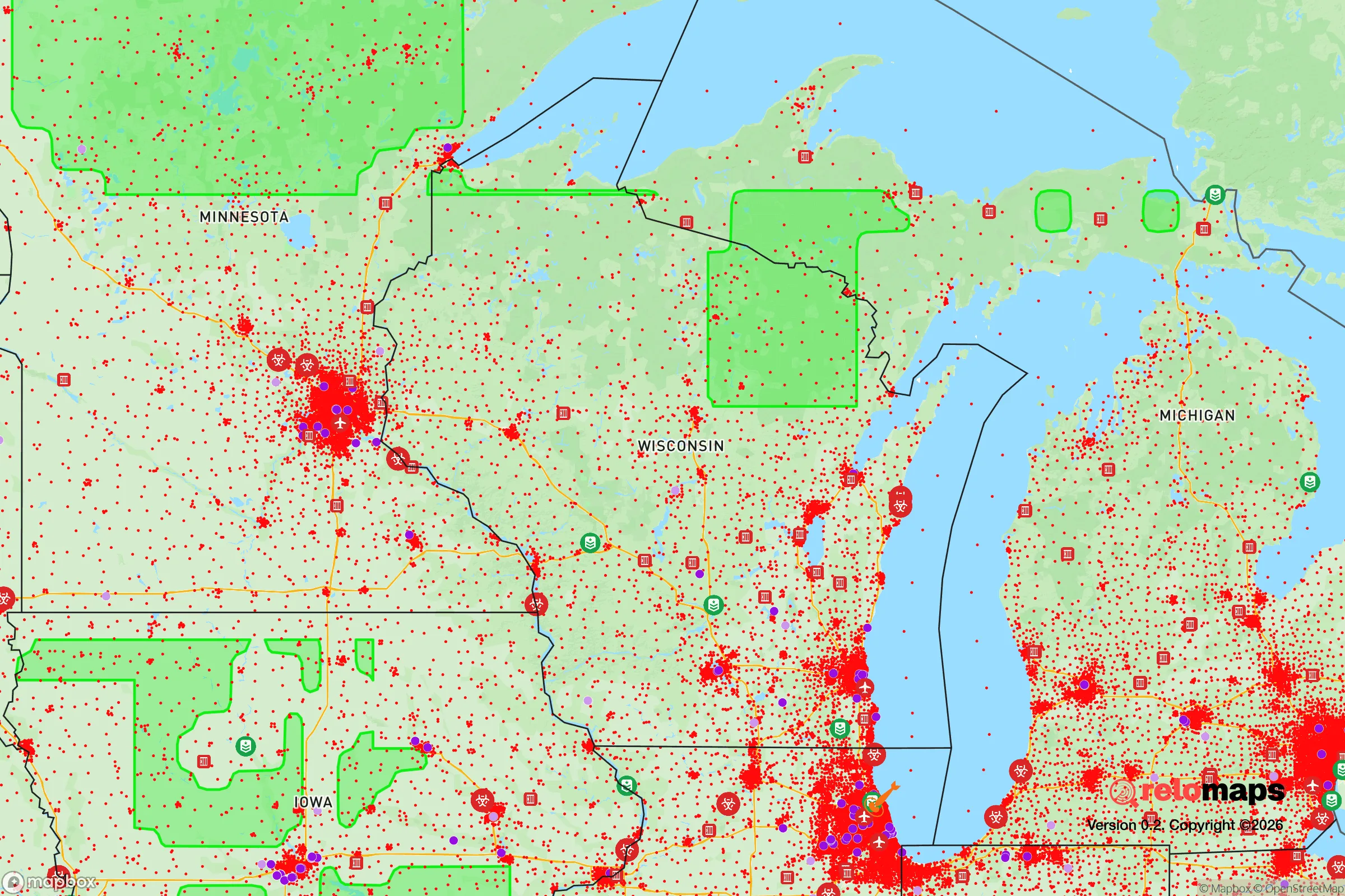
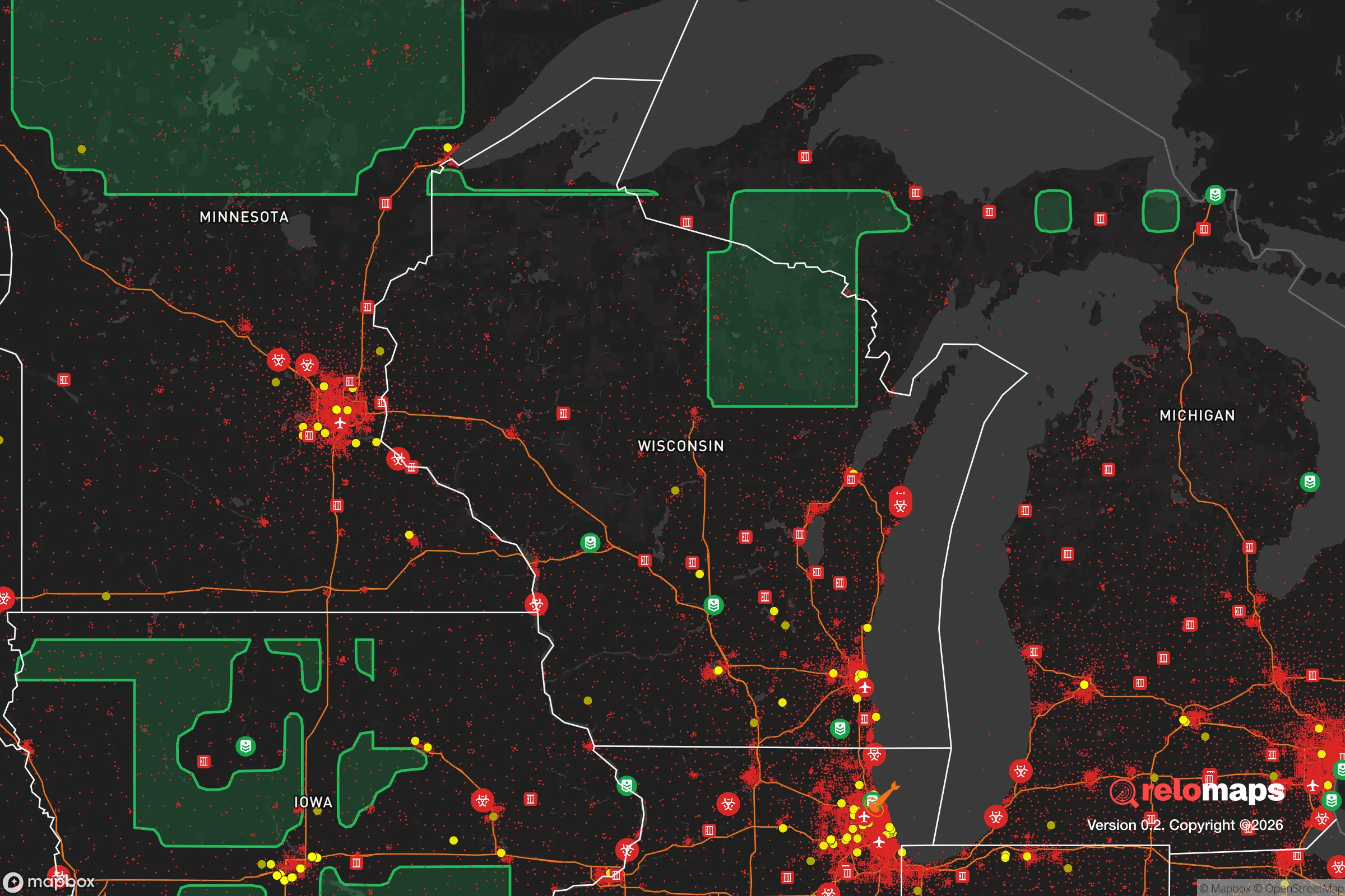
Important Note: For informational purposes only. This does not mean nothing bad ever happens in the green zones. Please use common sense. This is based on public data and modeled with AI. We tried to take a conservative approach but mistakes happen. We update this regularly as new information becomes available.
Solar Generator Recommendations
Backup power matters more here than in safer locations. We've picked three solar generators across budgets and capacity tiers — start with the budget unit if you only need a few essentials, or step up if you want to run a fridge and HVAC for days at a time.

Jackery Portable Power Station Explorer 300
Budget OptionPower on the Go: Weighing only 11 lbs, it's convenient to set up and store with book-sized foldable solar panels

BLUETTI Portable Power Station AC180
Designed for both indoor and outdoor scenarios, AC180 is highly capable as it has a robost capacity and continuous output power.

EF ECOFLOW DELTA Pro Ultra Power Station
Upgraded PickEcoFlow DELTA Pro Ultra is a whole-home energy system designed to grow with your family. Integrated with the Smart Home Panel 2, it scales to meet your evolving energy needs — keeping your home powered, intelligent, and secure through every stage of life.
We earn a commission, at no additional cost to you.
Strategic Assessment Analysis
Waukesha, Wisconsin, sits in a strategic sweet spot that preppers and survival-minded conservatives should take seriously: close enough to Milwaukee for supply runs and employment, yet far enough to avoid the worst of urban collapse scenarios. The city’s location along the Fox River and its position as the seat of Waukesha County give it a built-in administrative and logistical backbone that most bedroom communities lack. For someone looking to ride out civic unrest, mass casualty events, or natural disasters, Waukesha offers a rare combination of proximity to resources and genuine buffer from the chaos that tends to ignite in larger population centers.
Geographic position and natural advantages for long-term security
Waukesha’s geography is its first line of defense. The city sits roughly 20 miles west of Milwaukee, placing it outside the immediate blast radius of any major urban target while still within a reasonable drive for resupply or medical care. The Fox River cuts through the area, providing a reliable freshwater source that doesn’t depend on municipal treatment plants—critical if grid water goes down. The surrounding landscape is a mix of rolling hills, hardwood forests, and agricultural land, which means natural cover, firewood, and local food production are all within a short drive. The Kettle Moraine State Forest, just south and west of the city, offers thousands of acres of public land for hunting, foraging, and temporary retreat if things get hot in town. Unlike flat, open prairie counties to the west, Waukesha County’s terrain gives you defensible positions and multiple escape routes—north toward Fond du Lac, west toward Madison, or south toward the Illinois border. The area’s groundwater is abundant, thanks to the deep sandstone aquifer, and the city has its own water utility that draws from wells, not Lake Michigan pipelines that could be interdicted. For a relocator thinking in decades, not days, that water independence is a quiet but massive advantage.
Risks, exposures, and proximity to fallout-relevant landmarks
No location is perfect, and Waukesha has real vulnerabilities that a strategic relocator must weigh. The most obvious is its proximity to Milwaukee—only 20 miles east. If a mass casualty event, EMP strike, or civil unrest hits the city, expect refugees to flow west along I-94 and Highway 18. Waukesha sits directly in that funnel. The city itself has a population of about 72,000, which swells during work hours with commuters from Milwaukee. That means the local grocery stores, gas stations, and pharmacies could be stripped within hours of a major event. There’s also the matter of critical infrastructure: the Waukesha County Airport (UES) is a general aviation field that could become a target for looters or a staging ground for FEMA-style operations you might want to avoid. The city’s downtown rail lines, used by freight and the occasional Amtrak service, are chokepoints that could be blocked or sabotaged. On the industrial side, Waukesha has a history of manufacturing, including metal fabrication and chemical plants along the Fox River. A fire or spill at one of those facilities during a grid-down scenario could contaminate local water or air. And while the area is not in a high-risk tornado alley, severe thunderstorms and straight-line winds are common—enough to knock out power for days, which is a stress test for any prepper’s setup. The nuclear power plant at Point Beach, about 70 miles north, is a low-probability but high-consequence risk; prevailing winds would carry fallout southeast, away from Waukesha, but you’d still want to monitor that.
Practical resilience for a relocator: food, water, energy, and defensibility
For the individual or family looking to establish a resilient base, Waukesha offers a mix of suburban convenience and rural access that’s hard to beat in southeastern Wisconsin. The city has multiple farmers’ markets (the one in downtown Waukesha runs from May to October) and is surrounded by u-pick orchards, CSAs, and small farms that can supply fresh produce without relying on national supply chains. The Fox River is fishable year-round—species include smallmouth bass, walleye, and northern pike—and the state’s hunting regulations are generous for deer and turkey in Waukesha County. Water is the bigger concern: while the aquifer is reliable, a well pump requires electricity. Solar panels with battery storage are a smart investment here, as the grid is aging and prone to outages during winter ice storms. The city’s building codes are moderate, meaning you can install a wood stove or backup generator without excessive red tape, and many homes have basements that double as storm shelters or root cellars. Defensibility is where Waukesha gets interesting. The city is laid out in a grid around the Fox River, with several bridges that could be controlled if needed. The residential neighborhoods west of the river, like those around Frame Park and the downtown historic district, offer older homes with thick walls, fenced yards, and multiple egress points. The newer subdivisions on the city’s outskirts are more vulnerable—cookie-cutter layouts with single entrances that could be easily blocked. For a relocator, the smart play is to buy or rent in the older, denser parts of town where you can blend in, keep a low profile, and have neighbors who’ve been there for decades. The Waukesha County Sheriff’s Office is well-funded and generally conservative-leaning, which means a faster response time for rural calls compared to Milwaukee County. But don’t count on them in a widespread event—self-reliance is the name of the game.
The overall strategic picture for Waukesha is cautiously optimistic for the prepper-minded relocator. It’s not a bug-out location in the mountains, but it’s a solid base of operations for someone who wants to stay connected to the regional economy while maintaining a realistic fallback plan. The city’s water independence, defensible terrain, and access to local food sources give it a resilience score that beats most suburbs in the Midwest. The downsides—proximity to Milwaukee, industrial risks, and refugee flow corridors—are manageable with proper planning, like stocking extra supplies for the first 72 hours and having a secondary retreat in the Kettle Moraine. For a conservative audience worried about the direction of the country, Waukesha offers a place where you can still live a normal life while quietly stacking the odds in your favor. It’s not a fortress, but it’s a damn sight better than being trapped in a city when the lights go out.
* Values derived from national, state, county, city and local statistics and may differ in a specific area. Last updated: 2026-04-21T10:22:50.000Z
Narrative content on this page is AI-generated and may contain mistakes. Verify any details that matter before acting on them.
ReloMaps may earn a commission from affiliate links at no extra cost to you.