
Photo: Wikipedia
Strategic Assessment of Wellesley, MA
Meaningful friction. Expect exposure to either population pressure, blast zones, or natural disaster risk. Consider buying a retreat property.
What does the Strategic Assessment tell us?
Our Strategic Assessment grades tactical survivability of an area. Major population centers, military targets, fallout zones, natural disasters, and border exposure all drive risk — lower exposure means a more defensible position in a crisis.
This is heavily inspired by Joel Skousen's Strategic Relocation book. Highly recommended you checkout the book ($)What does this tell us?
Our Strategic Assessment grades tactical survivability of an area. Major population centers, military targets, fallout zones, natural disasters, and border exposure all drive risk — lower exposure means a more defensible position in a crisis.
This is heavily inspired by Joel Skousen's Strategic Relocation book. Highly recommended you checkout the book ($)Strategic Pillars

Key Distances
Regional Safe Places
Below is our recommended "safe zones" in Massachusetts and the surrounding area based on our strategic heuristics. For most people, it's unrealistic to live in a “safe zone” full-time due to work, family or other personal reasons. They tend to be more rural. However, many of these areas are perfect for second homes and retreat properties that double as a vacation home or even a short-term rental.


Important Note: For informational purposes only. This does not mean nothing bad ever happens in the green zones. Please use common sense. This is based on public data and modeled with AI. We tried to take a conservative approach but mistakes happen. We update this regularly as new information becomes available.
Solar Generator Recommendations
Backup power matters more here than in safer locations. We've picked three solar generators across budgets and capacity tiers — start with the budget unit if you only need a few essentials, or step up if you want to run a fridge and HVAC for days at a time.

Jackery Portable Power Station Explorer 300
Budget OptionPower on the Go: Weighing only 11 lbs, it's convenient to set up and store with book-sized foldable solar panels

BLUETTI Portable Power Station AC180
Designed for both indoor and outdoor scenarios, AC180 is highly capable as it has a robost capacity and continuous output power.

EF ECOFLOW DELTA Pro Ultra Power Station
Upgraded PickEcoFlow DELTA Pro Ultra is a whole-home energy system designed to grow with your family. Integrated with the Smart Home Panel 2, it scales to meet your evolving energy needs — keeping your home powered, intelligent, and secure through every stage of life.
We earn a commission, at no additional cost to you.
Strategic Assessment Analysis
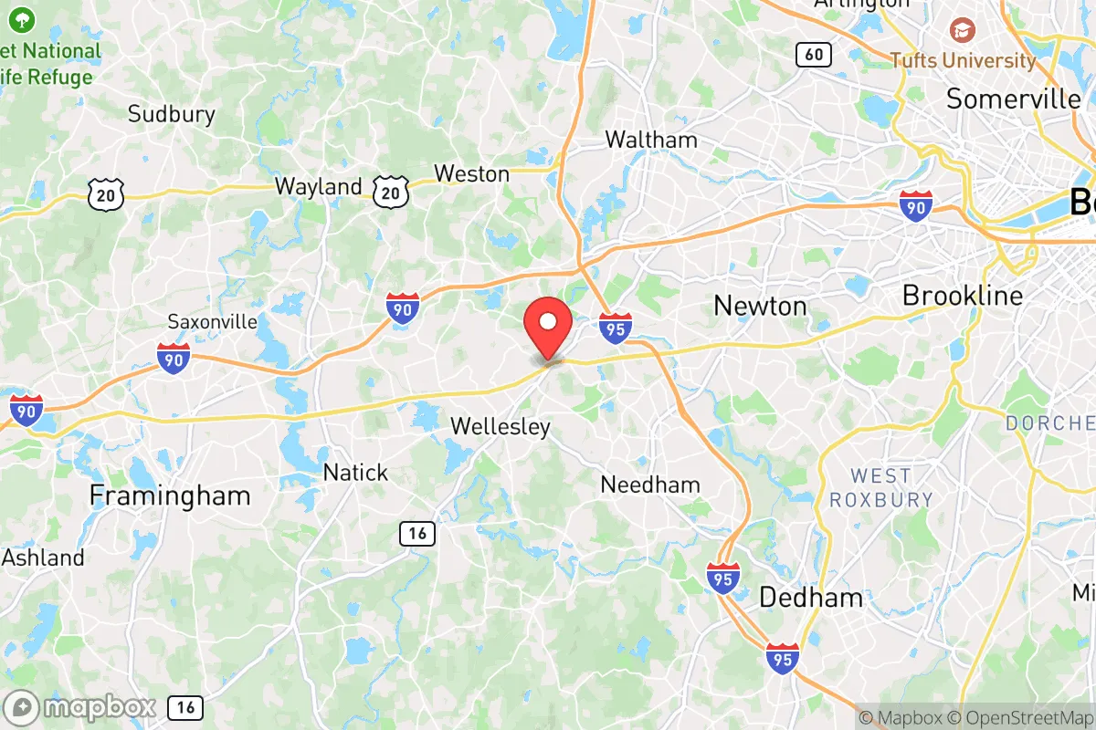
Wellesley, Massachusetts presents a complex strategic picture for the conservative prepper or survivalist. Its immediate advantages—a wealthy, well-maintained town with strong local governance and low crime—are offset by its proximity to Boston, a high-value target for any number of scenarios. The town’s resilience is real, but it’s a resilience built on the assumption that the surrounding infrastructure remains intact. For a relocator thinking in terms of decades, not election cycles, Wellesley is a high-utility, high-risk location that demands a clear-eyed assessment of its geographic and political vulnerabilities.
Geographic position and natural advantages for long-term stability
Wellesley sits roughly 15 miles west of downtown Boston, placing it in a suburban buffer zone that offers some natural advantages. The town is part of the Charles River watershed, with the river itself forming part of its northern border. This provides a reliable surface water source, though it’s heavily managed and not pristine. The area is hilly, with elevations ranging from 100 to 200 feet above sea level, which offers modest defensibility and good drainage—flooding is rare outside of the immediate riverbanks. The town’s tree canopy is dense, with large lots and winding roads that create natural chokepoints and reduce line-of-sight for any potential surveillance or unrest. The local soil is a mix of glacial till and loam, suitable for small-scale gardening, though the growing season is short (roughly 150 days). Wellesley’s position west of Boston also means it’s upwind of the city’s prevailing weather patterns, a minor but real advantage in the event of an airborne contaminant release from the urban core.
Risks, exposures, and proximity to fallout-relevant landmarks
The single greatest strategic liability is Wellesley’s proximity to Boston, a city that is both a political and economic hub and a prime target for civil unrest, terrorist attack, or even a limited nuclear exchange. The town sits directly along the Massachusetts Turnpike (I-90) and the MBTA commuter rail, both of which would become evacuation corridors or vectors for looting in a crisis. Wellesley is also within 10 miles of Hanscom Air Force Base (a major command and control node) and within 20 miles of the Boston Harbor and Logan International Airport, both high-value military targets. The town itself hosts Wellesley College, a prominent liberal arts institution that could become a focal point for protest or political violence during periods of national instability. Additionally, the town’s water supply is drawn from the Massachusetts Water Resources Authority (MWRA) system, which relies on the Quabbin Reservoir—a single, vulnerable pipeline corridor that runs through multiple urban areas. A coordinated attack on that system would leave Wellesley without municipal water for weeks. The town’s electrical grid is also tied to the regional ISO-New England system, which has shown fragility during winter storms and heat waves. In short, Wellesley is not a retreat; it is a forward operating base with a direct line of sight to the most volatile parts of the Northeast.
Practical resilience for a relocator: food, water, energy, and defensibility
For the individual or family looking to establish a resilient household, Wellesley offers a mixed bag. Food security is moderate: the town has several high-end grocery stores (Roche Bros., Whole Foods) and a farmers’ market, but these are supply-chain dependent. Local agriculture is limited to a few small farms (e.g., the Wellesley Community Farm) and backyard gardens. A serious prepper would need to invest in a greenhouse and cold frames to extend the season. Water is the critical vulnerability. The MWRA system is reliable day-to-day, but a grid-down scenario or contamination event would leave residents dependent on bottled water or private wells—only a fraction of homes have wells, and those are shallow. A rainwater catchment system with proper filtration is a wise investment. Energy resilience is achievable but expensive. Solar panels are common in Wellesley, but net metering policies are state-controlled and subject to change. A backup generator with a 500-gallon propane tank is the gold standard here, as natural gas lines are vulnerable to earthquakes and sabotage. Defensibility is surprisingly good for a suburb. The town’s layout—curving roads, large lots, and dense tree cover—makes it difficult to patrol or control. A well-prepared household with a good fence line, motion-sensor lighting, and a clear field of fire from the second story could hold out for a short period. However, the town’s police force is small (about 40 officers) and would be overwhelmed in a widespread event. The local population is overwhelmingly liberal and wealthy, which means that in a collapse scenario, you would be surrounded by people with more resources than survival skills—a double-edged sword. They are less likely to be armed (Massachusetts has strict gun laws) but more likely to be desperate.
The overall strategic picture for a conservative relocator
Wellesley is not a bug-out location; it is a high-functioning suburb that offers a comfortable life during stable times but carries significant tail risks. Its strengths—good schools, low crime, strong local governance, and a physically defensible layout—are real. Its weaknesses—proximity to a major target city, dependence on fragile infrastructure, a politically hostile state government, and a population ill-suited for hard times—are equally real. For a conservative prepper, the calculus comes down to this: if you believe the next decade will see a slow, managed decline with occasional disruptions, Wellesley is a fine place to ride it out. If you believe a sudden, catastrophic event is likely, you need a secondary location farther west—perhaps in the Berkshires or rural New Hampshire—where you can retreat to land you own, water you control, and neighbors who share your worldview. Wellesley is a base of operations, not a fortress. Treat it as such, and you can make it work. Treat it as a sanctuary, and you will be caught flat-footed.
* Values derived from national, state, county, city and local statistics and may differ in a specific area. Last updated: 2026-04-16T01:00:27.000Z
Narrative content on this page is AI-generated and may contain mistakes. Verify any details that matter before acting on them.
ReloMaps may earn a commission from affiliate links at no extra cost to you.