Photo: Wikipedia
Strategic Assessment of West New York, NJ
High tactical risk. This location is likely close to major population centers, strategic targets, or sits in a high-disaster corridor. A retreat property and careful exit planning is required.
What does the Strategic Assessment tell us?
Our Strategic Assessment grades tactical survivability of an area. Major population centers, military targets, fallout zones, natural disasters, and border exposure all drive risk — lower exposure means a more defensible position in a crisis.
This is heavily inspired by Joel Skousen's Strategic Relocation book. Highly recommended you checkout the book ($)What does this tell us?
Our Strategic Assessment grades tactical survivability of an area. Major population centers, military targets, fallout zones, natural disasters, and border exposure all drive risk — lower exposure means a more defensible position in a crisis.
This is heavily inspired by Joel Skousen's Strategic Relocation book. Highly recommended you checkout the book ($)Strategic Pillars

Key Distances
Regional Safe Places
Below is our recommended "safe zones" in New Jersey and the surrounding area based on our strategic heuristics. For most people, it's unrealistic to live in a “safe zone” full-time due to work, family or other personal reasons. They tend to be more rural. However, many of these areas are perfect for second homes and retreat properties that double as a vacation home or even a short-term rental.


Important Note: For informational purposes only. This does not mean nothing bad ever happens in the green zones. Please use common sense. This is based on public data and modeled with AI. We tried to take a conservative approach but mistakes happen. We update this regularly as new information becomes available.
Solar Generator Recommendations
Backup power matters more here than in safer locations. We've picked three solar generators across budgets and capacity tiers — start with the budget unit if you only need a few essentials, or step up if you want to run a fridge and HVAC for days at a time.

Jackery Portable Power Station Explorer 300
Budget OptionPower on the Go: Weighing only 11 lbs, it's convenient to set up and store with book-sized foldable solar panels

BLUETTI Portable Power Station AC180
Designed for both indoor and outdoor scenarios, AC180 is highly capable as it has a robost capacity and continuous output power.

EF ECOFLOW DELTA Pro Ultra Power Station
Upgraded PickEcoFlow DELTA Pro Ultra is a whole-home energy system designed to grow with your family. Integrated with the Smart Home Panel 2, it scales to meet your evolving energy needs — keeping your home powered, intelligent, and secure through every stage of life.
We earn a commission, at no additional cost to you.
Strategic Assessment Analysis
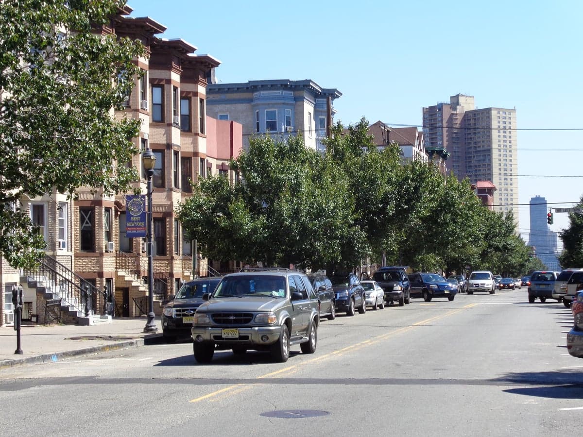
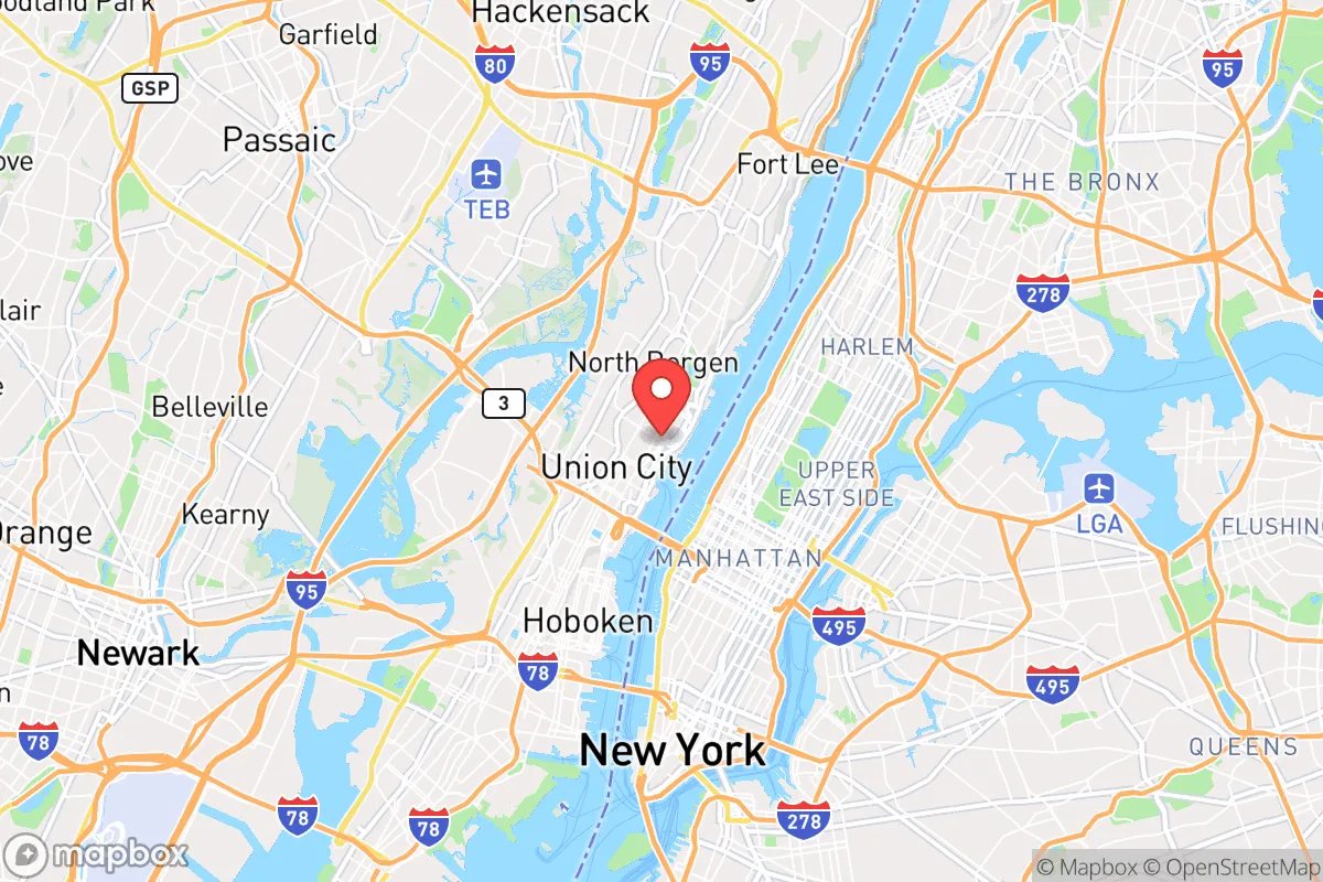
West New York, New Jersey, presents a complex strategic picture for the conservative prepper or survivalist. Its primary resilience advantage is its location on the New Jersey Palisades, a natural high-ground feature that offers a commanding view of the Hudson River and Manhattan, but its proximity to New York City is a double-edged sword. While the town itself is densely populated and lacks the rural buffer many preppers seek, its position on a bluff provides a defensible perch and a degree of separation from the immediate chaos of a major urban collapse. The key question for a relocator is whether the tactical benefits of this high-ground observation post outweigh the overwhelming risks of being within a stone's throw of one of the world's most likely targets for civil unrest, mass casualty events, or a coordinated attack.
Geographic position and natural advantages for strategic relocation
West New York sits atop the Hudson Palisades, a series of steep cliffs that rise roughly 200 feet above the Hudson River. This elevation is the town's single greatest natural asset. From this vantage point, a resident can observe activity across the river in Midtown Manhattan and along the New Jersey waterfront for miles. In a scenario involving civil unrest or a mass casualty event in New York City, this high ground offers early warning and a physical barrier that low-lying areas like Hoboken or Jersey City lack. The cliffs themselves create a natural choke point; access from the riverfront is limited to a few steep streets and staircases, making the town more defensible against ground-level incursion. Additionally, the Palisades are part of a larger Interstate Park system, providing a narrow green corridor of forested cliffs that could serve as a limited escape route northward toward less populated areas of Bergen County. The Hudson River, while a barrier, also offers a potential water source and a natural boundary that slows movement from the west. However, the town's footprint is only about one square mile, meaning any natural advantage is confined to a very small, densely built-up area.
Risks, exposures, and proximity to fallout-relevant landmarks
The most glaring vulnerability of West New York is its proximity to New York City, specifically Manhattan, which is less than two miles away. In a major event—whether a terrorist attack, a grid-down scenario, or widespread civil unrest—the town would be directly in the fallout zone, both literally and figuratively. The Lincoln Tunnel, which empties into Weehawken just south of West New York, is a primary evacuation route for Manhattan. In a crisis, this tunnel would become a bottleneck of panic, and the surrounding streets would be clogged with fleeing vehicles and desperate people. West New York itself is a densely packed urban environment with a population density exceeding 50,000 people per square mile. This density means that any cascading failure—food shortages, water contamination, or disease outbreak—would spread rapidly. The town is also within the blast radius of several high-value targets: the Port Authority of New York and New Jersey, the United Nations headquarters, and the financial district. A conventional or dirty bomb detonated in Midtown could send fallout across the river, and the prevailing westerly winds would push contamination directly into Hudson County. Furthermore, the town's reliance on regional infrastructure—power from the PJM grid, water from the Newark watershed, and food from the New York metropolitan distribution network—means that a disruption in the city would immediately cascade into West New York.
Practical resilience for a relocator: food, water, energy, and defensibility
For a relocator with a prepper mindset, West New York presents severe practical challenges. Food and water independence is nearly impossible in a one-square-mile town with no agricultural land and limited private wells. Residents depend entirely on municipal water supplies and grocery stores that would empty within hours of a crisis. Energy resilience is also poor; the town's housing stock consists largely of multi-family apartment buildings and rowhouses, where solar panel installation is impractical and generator use is limited by noise, fuel storage, and fire codes. The electrical grid is overhead and vulnerable to storms and sabotage. Defensibility is a mixed picture. The Palisades provide a natural barrier on the east, but the town is wide open from the west and south, with multiple arterial roads feeding in from Union City, North Bergen, and the New Jersey Turnpike. Securing a single-family home with a yard is rare and expensive, with median home prices well over $500,000 for a small rowhouse. Most residents live in apartments with shared entrances, making individual hardening difficult. The best-case scenario for a prepper here would be to secure a top-floor unit in a building with a rooftop water tank and a backup generator, but even then, the density of neighbors creates a security risk. Evacuation routes are limited: the main roads (Boulevard East, Bergenline Avenue, and 43rd Street) would gridlock instantly, and the only viable escape would be on foot or by bicycle, heading north toward the Palisades Interstate Park or west toward the Meadowlands.
In the overall strategic picture, West New York is a high-risk, high-cost location that offers a unique observation post but little else for the serious prepper. Its primary value is as a temporary staging point for someone who needs to monitor events in New York City while maintaining a quick escape route north. For a conservative relocator seeking long-term resilience, the town's density, lack of self-sufficiency, and proximity to a major target make it a poor choice for a permanent retreat. The money and effort required to harden a residence here would be better spent on a property in a rural area with land, water, and a lower population density. However, for someone who must remain in the New York metro area for work or family reasons, West New York's high ground and limited access points make it one of the less bad options in Hudson County—provided you have a solid bug-out plan and are prepared to leave at the first sign of trouble. The cliffs give you a view, but they won't save you from the fallout.
* Values derived from national, state, county, city and local statistics and may differ in a specific area. Last updated: 2026-04-30T04:25:26.000Z
Narrative content on this page is AI-generated and may contain mistakes. Verify any details that matter before acting on them.
ReloMaps may earn a commission from affiliate links at no extra cost to you.