
Photo: Wikipedia
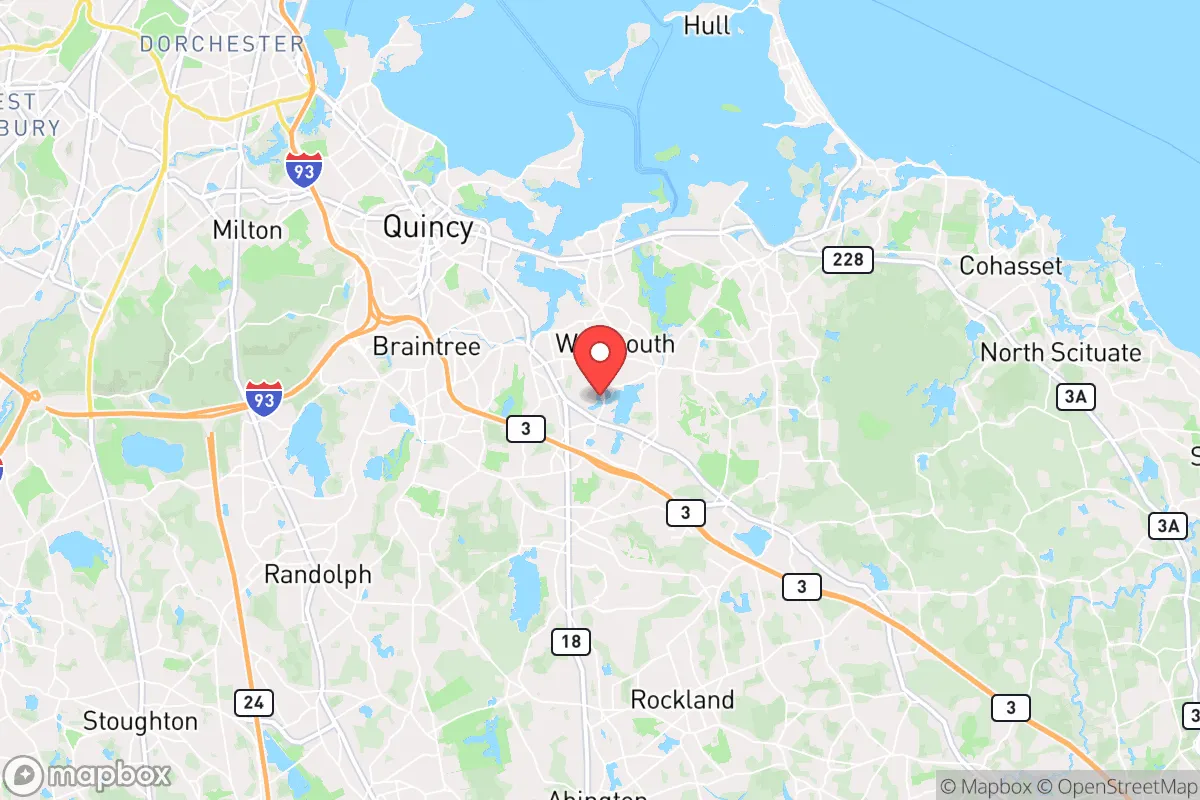
Strategic Assessment of Weymouth Town, MA
Multiple tactical vulnerabilities. Population density, target proximity, or disaster risk are likely compounding. A retreat property and exit planning is required.
What does the Strategic Assessment tell us?
Our Strategic Assessment grades tactical survivability of an area. Major population centers, military targets, fallout zones, natural disasters, and border exposure all drive risk — lower exposure means a more defensible position in a crisis.
This is heavily inspired by Joel Skousen's Strategic Relocation book. Highly recommended you checkout the book ($)What does this tell us?
Our Strategic Assessment grades tactical survivability of an area. Major population centers, military targets, fallout zones, natural disasters, and border exposure all drive risk — lower exposure means a more defensible position in a crisis.
This is heavily inspired by Joel Skousen's Strategic Relocation book. Highly recommended you checkout the book ($)Strategic Pillars

Key Distances
Regional Safe Places
Below is our recommended "safe zones" in Massachusetts and the surrounding area based on our strategic heuristics. For most people, it's unrealistic to live in a “safe zone” full-time due to work, family or other personal reasons. They tend to be more rural. However, many of these areas are perfect for second homes and retreat properties that double as a vacation home or even a short-term rental.


Important Note: For informational purposes only. This does not mean nothing bad ever happens in the green zones. Please use common sense. This is based on public data and modeled with AI. We tried to take a conservative approach but mistakes happen. We update this regularly as new information becomes available.
Solar Generator Recommendations
Backup power matters more here than in safer locations. We've picked three solar generators across budgets and capacity tiers — start with the budget unit if you only need a few essentials, or step up if you want to run a fridge and HVAC for days at a time.

Jackery Portable Power Station Explorer 300
Budget OptionPower on the Go: Weighing only 11 lbs, it's convenient to set up and store with book-sized foldable solar panels

BLUETTI Portable Power Station AC180
Designed for both indoor and outdoor scenarios, AC180 is highly capable as it has a robost capacity and continuous output power.

EF ECOFLOW DELTA Pro Ultra Power Station
Upgraded PickEcoFlow DELTA Pro Ultra is a whole-home energy system designed to grow with your family. Integrated with the Smart Home Panel 2, it scales to meet your evolving energy needs — keeping your home powered, intelligent, and secure through every stage of life.
We earn a commission, at no additional cost to you.
Strategic Assessment Analysis
Weymouth Town, Massachusetts, sits in a precarious strategic position that demands a clear-eyed assessment for anyone prioritizing resilience and preparedness. While its coastal location and proximity to Boston offer economic advantages, these same factors create significant vulnerabilities for those concerned with civic unrest, mass casualty events, or large-scale disasters. For a conservative-leaning relocator focused on self-sufficiency and security, Weymouth presents a mixed picture: it is not a hardened redoubt, but it is not a complete write-off either, provided you understand its specific risk profile and plan accordingly.
Geographic position and natural advantages for a prepper
Weymouth occupies a peninsula-like position on Boston’s South Shore, bordered by Hingham Bay and the Weymouth Back River. This geography offers a few genuine advantages for a survival-minded individual. The town’s access to multiple waterways provides natural barriers to ground-based movement, which could slow or channel any large-scale unrest or refugee flow from Boston, roughly 12 miles north. The presence of the Weymouth Back River and Whitman’s Pond offers potential secondary water sources, though treatment would be mandatory. The area’s numerous small parks and conservation lands, like the Great Esker Park, provide limited but usable terrain for foraging or temporary cover. However, the land is largely developed suburban sprawl, with little true wilderness. The town’s elevation is low—most of it sits below 50 feet—which is a concern for storm surge but not for line-of-sight observation. For a relocator, the key natural advantage is the proximity to the ocean for fishing and potential maritime escape routes, but this is a double-edged sword, as the coast is also a primary target for both natural and man-made threats.
Risks, exposures, and proximity to fallout-relevant landmarks
This is where Weymouth’s strategic assessment becomes sobering. The town is directly adjacent to the South Weymouth Naval Air Station (now a mixed-use development), a former military installation that, while largely decommissioned, still hosts some federal operations. Any military-associated site is a potential target during a conflict or a focal point for government activity during unrest. More critically, Weymouth lies within the primary fallout zone of the Pilgrim Nuclear Power Station in Plymouth (roughly 15 miles south), and within the broader risk radius of the Seabrook Station in New Hampshire. A nuclear incident—whether from accident or attack—would render large portions of the South Shore uninhabitable for years. Additionally, the town is crisscrossed by major evacuation routes like Route 3, Route 18, and the Southeast Expressway (I-93), which would become instant choke points during any mass evacuation from Boston. During a crisis, these roads would be clogged with fleeing urban populations, making Weymouth a bottleneck rather than a sanctuary. The Logan International Airport and Boston Harbor shipping channels are also within easy striking distance for any airborne or maritime threat, meaning the town sits in a high-value target zone. For a prepper, the concentration of population and infrastructure in the Boston metro area is a massive negative—Weymouth is essentially a suburb of a primary target.
Practical resilience for a relocator: food, water, energy, and defensibility
On the ground, Weymouth’s practical resilience is underwhelming for a serious preparedness plan. Food security is poor: the town has no significant agricultural land, and the local grocery stores (Stop & Shop, Shaw’s) are standard suburban chains that would empty within hours of a crisis. Community gardens exist but are small and not sufficient for a population of over 55,000. Water is a mixed asset: the town draws from the Massachusetts Water Resources Authority (MWRA) system, which is a centralized, vulnerable infrastructure. A prolonged grid failure or contamination event would cut off supply. While Whitman’s Pond and the Back River are available, they are brackish or polluted, requiring advanced filtration or distillation. Energy dependence is high: Weymouth is entirely reliant on the regional power grid, with no municipal power plant or significant local generation. Solar adoption is growing but not widespread enough to create a resilient microgrid. Natural gas lines run through the area, but these are also vulnerable to disruption. Defensibility is the weakest point: the town is a dense, interconnected suburban grid with few natural chokepoints. The street network is designed for car access, not perimeter defense. A determined group or mob could move through neighborhoods with ease. The Weymouth Police Department is professional but small (around 100 officers) for a town of this size, and during a widespread event, they would be overwhelmed. The town’s proximity to the Blue Hills Reservation offers some escape route into more rugged terrain, but that area is also heavily used and not a true wilderness refuge. For a relocator, the practical takeaway is that Weymouth requires a high degree of self-sufficiency in storage, water purification, and off-grid power, and even then, the location’s inherent vulnerabilities make it a temporary holding area rather than a long-term survival location.
The overall strategic picture for Weymouth is that it functions as a buffer zone with limited long-term viability for a serious prepper. Its advantages—coastal access, proximity to Boston’s economy, and established infrastructure—are real for daily life in stable times. But for someone concerned with civil unrest, mass casualty events, or large-scale disasters, the negatives are substantial: high population density, proximity to primary targets (Boston, military sites, nuclear plants), vulnerable infrastructure, and poor defensibility. Weymouth could serve as a temporary staging point for a coastal retreat or as a location for those who must remain near Boston for work or family obligations, but it is not a place to hunker down for a long-term crisis. A conservative relocator would be better served looking further inland—toward central or western Massachusetts, or into New Hampshire—where population density drops, natural resources increase, and the fallout risk from coastal targets diminishes. Weymouth is a place to live, not a place to survive. Plan accordingly.
* Values derived from national, state, county, city and local statistics and may differ in a specific area. Last updated: 2026-05-01T15:48:24.000Z
Narrative content on this page is AI-generated and may contain mistakes. Verify any details that matter before acting on them.
ReloMaps may earn a commission from affiliate links at no extra cost to you.