Photo: Wikipedia
Strategic Assessment of Bellevue, WA
Multiple tactical vulnerabilities. Population density, target proximity, or disaster risk are likely compounding. A retreat property and exit planning is required.
What does the Strategic Assessment tell us?
Our Strategic Assessment grades tactical survivability of an area. Major population centers, military targets, fallout zones, natural disasters, and border exposure all drive risk — lower exposure means a more defensible position in a crisis.
This is heavily inspired by Joel Skousen's Strategic Relocation book. Highly recommended you checkout the book ($)What does this tell us?
Our Strategic Assessment grades tactical survivability of an area. Major population centers, military targets, fallout zones, natural disasters, and border exposure all drive risk — lower exposure means a more defensible position in a crisis.
This is heavily inspired by Joel Skousen's Strategic Relocation book. Highly recommended you checkout the book ($)Strategic Pillars

Key Distances
Regional Safe Places
Below is our recommended "safe zones" in Washington and the surrounding area based on our strategic heuristics. For most people, it's unrealistic to live in a “safe zone” full-time due to work, family or other personal reasons. They tend to be more rural. However, many of these areas are perfect for second homes and retreat properties that double as a vacation home or even a short-term rental.


Important Note: For informational purposes only. This does not mean nothing bad ever happens in the green zones. Please use common sense. This is based on public data and modeled with AI. We tried to take a conservative approach but mistakes happen. We update this regularly as new information becomes available.
Solar Generator Recommendations
Backup power matters more here than in safer locations. We've picked three solar generators across budgets and capacity tiers — start with the budget unit if you only need a few essentials, or step up if you want to run a fridge and HVAC for days at a time.

Jackery Portable Power Station Explorer 300
Budget OptionPower on the Go: Weighing only 11 lbs, it's convenient to set up and store with book-sized foldable solar panels

BLUETTI Portable Power Station AC180
Designed for both indoor and outdoor scenarios, AC180 is highly capable as it has a robost capacity and continuous output power.

EF ECOFLOW DELTA Pro Ultra Power Station
Upgraded PickEcoFlow DELTA Pro Ultra is a whole-home energy system designed to grow with your family. Integrated with the Smart Home Panel 2, it scales to meet your evolving energy needs — keeping your home powered, intelligent, and secure through every stage of life.
We earn a commission, at no additional cost to you.
Strategic Assessment Analysis
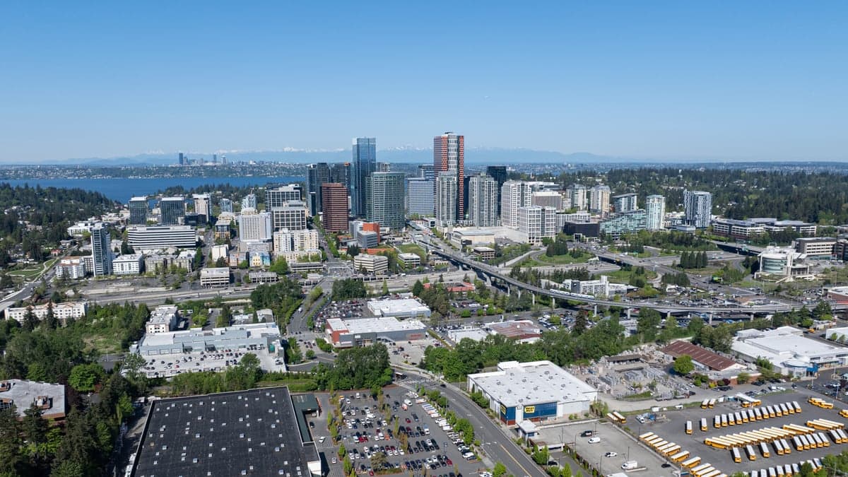
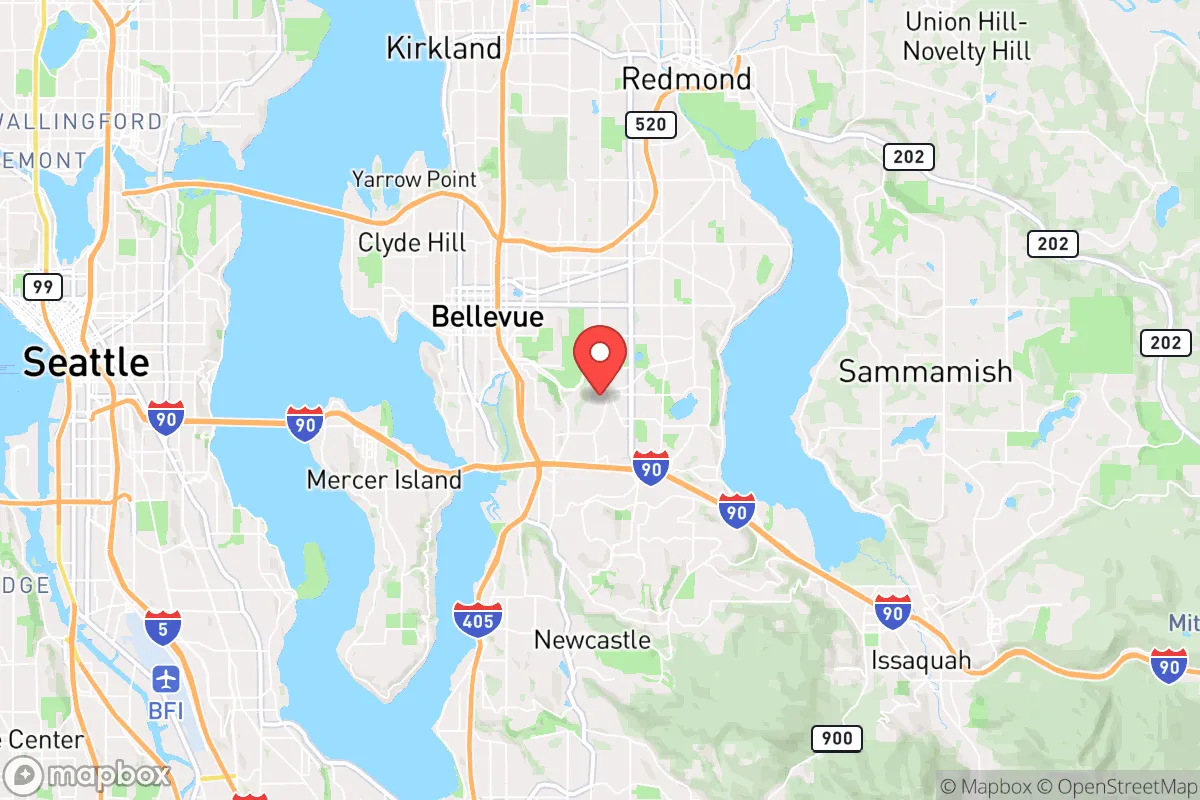
Bellevue, Washington, presents a complex strategic picture for the conservative prepper: it offers genuine natural-resilience advantages—abundant fresh water, defensible terrain, and a robust local economy—but sits uncomfortably close to Seattle’s political and population density, which introduces significant fallout risks. The city’s position on the eastern shore of Lake Washington, with the Cascade Range to the east and Puget Sound to the west, creates a natural buffer zone that can be leveraged for retreat, but its proximity to major infrastructure hubs (I-90, I-405, Sea-Tac Airport) means any mass casualty event or civic unrest in the Seattle metro area will ripple here quickly. For a relocator thinking in terms of long-term survival, Bellevue is a high-potential base camp—but only if you understand where the real vulnerabilities lie and plan accordingly.
Geographic position and natural advantages for long-term survival
Bellevue’s geography is its strongest card. The city sits on a plateau above Lake Washington, with the Cascade foothills rising just east of town. This elevation provides natural drainage and defensible high ground—critical if you’re thinking about flood risks or needing to hold a position during unrest. The lake itself is a massive, year-round freshwater source (over 20 miles long, up to 200 feet deep), and the surrounding watershed includes the Cedar and Snoqualmie rivers, which feed into the region’s aquifer. For a prepper, that means you’re not dependent on a single municipal supply; with proper filtration, you can draw water from multiple sources within a short drive. The Cascade Range also acts as a physical barrier against eastward threats—whether that’s a cascading power grid failure or population movement from the interior. Winters are mild (average lows in the 30s), so you won’t freeze to death, but you will deal with persistent cloud cover that limits solar generation—something to factor into your energy plan. The real strategic gem is the network of state and county parks (Cougar Mountain, Tiger Mountain, Squak Mountain) that form a greenbelt of forested ridges within 15 minutes of downtown. These provide both game habitat and potential bug-out routes if you need to exfiltrate east toward the Cascades or north toward the Skagit Valley.
Risks, exposures, and proximity to fallout-relevant landmarks
The downside is proximity. Bellevue is 8 miles from downtown Seattle and 12 miles from Sea-Tac International Airport, both of which are high-probability targets for civil unrest, mass casualty events, or infrastructure attacks. Seattle’s CHOP-style autonomous zones and recurring protest violence (2020–2021 saw over $4 billion in property damage citywide) demonstrate that political instability can spill across the lake quickly. The I-90 bridge connecting Bellevue to Seattle is a single chokepoint—if it’s blocked or destroyed, your primary route west is gone. More concerning: Boeing’s Renton facility (7 miles south) and the Puget Sound Naval Shipyard (25 miles southwest) are both critical national infrastructure that could become targets in a conflict scenario. The region also sits in the Cascadia subduction zone—a magnitude 9.0 earthquake is a statistical certainty within the next 50 years, and Bellevue’s soil composition (glacial till over clay) amplifies shaking. A major quake would likely collapse the I-90 and SR-520 bridges, isolate the city, and disrupt power, water, and sewage for weeks. The city’s reliance on hydroelectric power (90% of the grid) means a dam failure or grid attack could leave you in the dark for extended periods. For a prepper, the takeaway is: Bellevue’s natural advantages are real, but its exposure to Seattle’s instability and seismic risk means you need a layered plan—not just a single bug-out location.
Practical resilience for a relocator: food, water, energy, and defensibility
On the practical side, Bellevue scores mixed marks. Water is abundant—Lake Washington alone holds over 1 trillion gallons, and the city’s municipal supply comes from the Cedar River watershed, which is protected and gravity-fed (no pumps needed). You can store a 55-gallon drum and refill it from the lake with a simple hand pump and a Sawyer filter. Food is a bigger challenge: the city has no significant agricultural land within its limits. The closest farmland is in the Sammamish Valley (10 miles north) and the Snoqualmie Valley (15 miles east), where you’ll find small-scale farms, orchards, and livestock operations. Building relationships with those growers now—before a crisis—is smart. Energy: solar is marginal due to cloud cover (average 150 sunny days per year), but micro-hydro from the many creeks draining the Cascades is viable if you have property with a reliable stream. Propane is widely available at Costco and local suppliers, and wood heat is practical given the forested surroundings. Defensibility: Bellevue’s suburban sprawl (low-density, single-family homes on large lots) makes it harder to secure than a rural compound, but the terrain offers natural chokepoints—the lake to the west, the hills to the east, and the I-90 corridor as a funnel. A well-placed group of like-minded neighbors could control access to a neighborhood if you coordinate. The city’s police force is well-funded (over 200 officers for 150,000 residents) and generally professional, but in a widespread collapse, they’ll be overwhelmed. Your best bet is to form a mutual-assistance network with 3–5 nearby households, stockpile at least 90 days of food and medical supplies, and have a secondary bug-out location in the eastern Cascades (e.g., Cle Elum or Leavenworth) within a 2-hour drive.
Overall, Bellevue is a high-risk, high-reward location for the conservative prepper. Its natural water, defensible terrain, and economic stability make it a viable base for those who can afford the real estate and are willing to invest in layered preparedness. But the proximity to Seattle’s political volatility, the seismic threat, and the dependence on fragile infrastructure mean you cannot treat it as a permanent fortress. Think of it as a forward operating base—a place to build resources, network with other prepared individuals, and monitor the situation, with a clear exit plan to the east if things go sideways. If you’re single and mobile, it’s a solid option. If you’re moving a family, you’ll need to be disciplined about drills, supplies, and community ties. The region’s natural resilience is real, but it only works if you respect the risks and plan accordingly.
* Values derived from national, state, county, city and local statistics and may differ in a specific area. Last updated: 2026-04-21T11:04:03.000Z
Narrative content on this page is AI-generated and may contain mistakes. Verify any details that matter before acting on them.
ReloMaps may earn a commission from affiliate links at no extra cost to you.