Photo: Wikipedia
Strategic Assessment of Boulder, CO
Meaningful friction. Expect exposure to either population pressure, blast zones, or natural disaster risk. Consider buying a retreat property.
What does the Strategic Assessment tell us?
Our Strategic Assessment grades tactical survivability of an area. Major population centers, military targets, fallout zones, natural disasters, and border exposure all drive risk — lower exposure means a more defensible position in a crisis.
This is heavily inspired by Joel Skousen's Strategic Relocation book. Highly recommended you checkout the book ($)What does this tell us?
Our Strategic Assessment grades tactical survivability of an area. Major population centers, military targets, fallout zones, natural disasters, and border exposure all drive risk — lower exposure means a more defensible position in a crisis.
This is heavily inspired by Joel Skousen's Strategic Relocation book. Highly recommended you checkout the book ($)Strategic Pillars

Key Distances
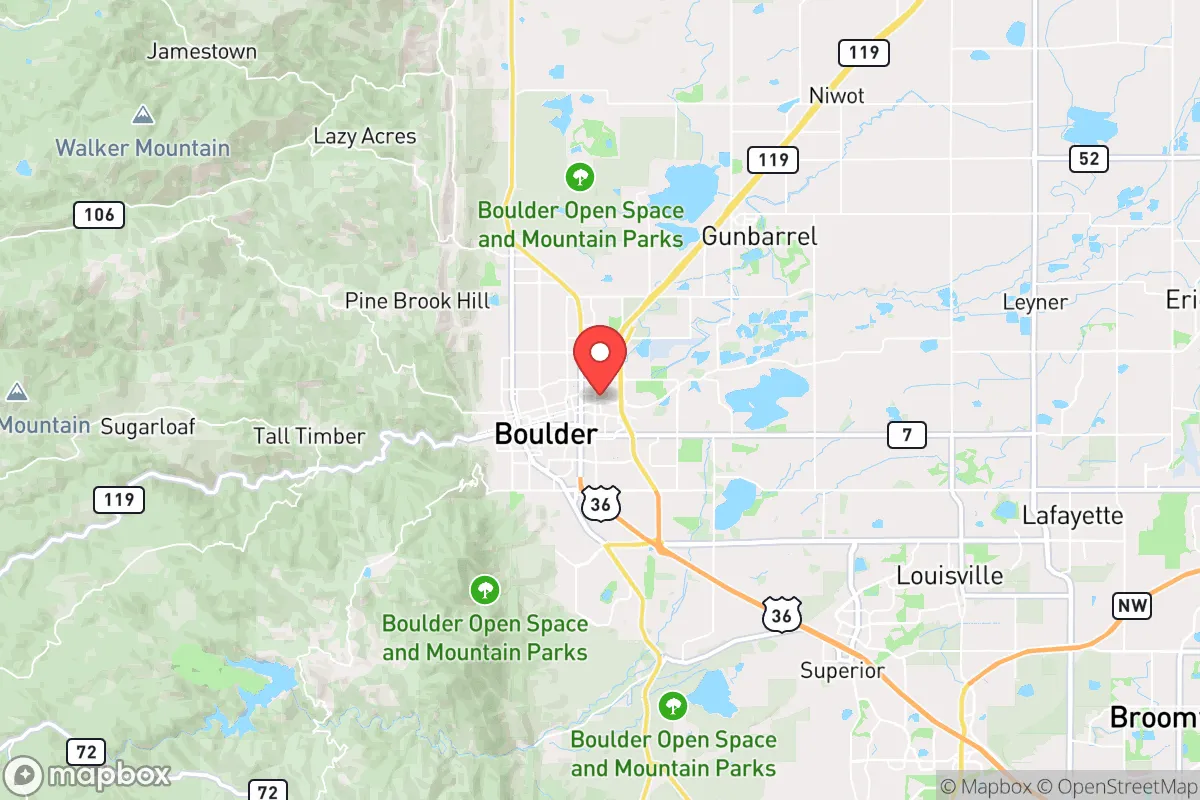
Regional Safe Places
Below is our recommended "safe zones" in Colorado and the surrounding area based on our strategic heuristics. For most people, it's unrealistic to live in a “safe zone” full-time due to work, family or other personal reasons. They tend to be more rural. However, many of these areas are perfect for second homes and retreat properties that double as a vacation home or even a short-term rental.


Important Note: For informational purposes only. This does not mean nothing bad ever happens in the green zones. Please use common sense. This is based on public data and modeled with AI. We tried to take a conservative approach but mistakes happen. We update this regularly as new information becomes available.
Solar Generator Recommendations
Backup power matters more here than in safer locations. We've picked three solar generators across budgets and capacity tiers — start with the budget unit if you only need a few essentials, or step up if you want to run a fridge and HVAC for days at a time.

Jackery Portable Power Station Explorer 300
Budget OptionPower on the Go: Weighing only 11 lbs, it's convenient to set up and store with book-sized foldable solar panels

BLUETTI Portable Power Station AC180
Designed for both indoor and outdoor scenarios, AC180 is highly capable as it has a robost capacity and continuous output power.

EF ECOFLOW DELTA Pro Ultra Power Station
Upgraded PickEcoFlow DELTA Pro Ultra is a whole-home energy system designed to grow with your family. Integrated with the Smart Home Panel 2, it scales to meet your evolving energy needs — keeping your home powered, intelligent, and secure through every stage of life.
We earn a commission, at no additional cost to you.
Strategic Assessment Analysis
Boulder, Colorado, presents a complex strategic picture for the conservative prepper or survivalist. On the surface, its location at the base of the Rocky Mountains offers genuine geographic advantages—high altitude, abundant water from snowmelt, and a defensible terrain that could serve as a fallback zone. However, the city itself is a dense, politically progressive urban hub that sits directly in the shadow of major vulnerabilities, including proximity to Denver, critical infrastructure, and a population that is overwhelmingly dependent on fragile supply chains. For a relocator prioritizing long-term resilience, Boulder is less a sanctuary and more a high-risk staging area that demands a clear-eyed assessment of its trade-offs.
Geographic position and natural advantages for a strategic relocation
Boulder’s primary strategic asset is its position at the mouth of Boulder Canyon, a natural choke point that funnels traffic into the Front Range. The city sits at roughly 5,400 feet elevation, with the Indian Peaks Wilderness and Roosevelt National Forest rising immediately to the west. This provides a rapid escape route into high-altitude terrain that is difficult to mechanize—a key consideration for any scenario involving civil unrest or grid-down conditions. The area’s geology includes granite outcroppings and steep canyons that could be used for natural observation posts or defensive positions. Water is abundant from Boulder Creek and the South Boulder Creek drainage, both fed by snowpack that typically persists through late spring. The city’s municipal water system draws from Barker Reservoir and Gross Reservoir, which are upstream and gravity-fed, meaning they would continue to flow even without power—though treatment would be compromised. For a relocator, the ability to access raw water within a short hike from most neighborhoods is a genuine advantage, though it requires filtration knowledge and gear. The Front Range also benefits from a relatively low risk of major earthquakes, hurricanes, or wildfires compared to other western regions, though wildfire risk is real and increasing. The growing season is short (about 120 days), but the soil in the Boulder Valley is fertile enough for small-scale gardening if you have the right microclimate and irrigation setup.
Risks, exposures, and proximity to fallout-relevant landmarks
The most glaring vulnerability for Boulder is its proximity to Denver, just 30 miles southeast. Denver is a major population center, a transportation hub (DIA is one of the busiest airports in the world), and a likely target for any large-scale disruption—whether economic collapse, civil unrest, or a coordinated attack. In a mass casualty event, the Denver metro area’s 3 million people would likely attempt to flee west into the mountains, and Boulder sits directly in that path. The only major highway out of Denver heading west is I-70, but US-36 and CO-93 also funnel traffic into Boulder. In a panic scenario, these roads would gridlock within hours. Boulder itself has a population of about 108,000, but the broader Boulder County population is over 330,000. That density, combined with a highly educated but largely urban-dependent populace, means that most residents have no practical survival skills and would become a liability in a prolonged crisis. Additionally, Boulder is within 50 miles of the Rocky Flats National Wildlife Refuge, a former nuclear weapons plant that remains a Superfund site. While the plutonium contamination is largely contained, any major disaster—wildfire, earthquake, or deliberate attack—could resuspend hazardous materials. The city also sits near the National Center for Atmospheric Research (NCAR) and the University of Colorado Boulder, which are potential targets for cyber or physical attacks given their research into sensitive technologies. For the prepper, these are not theoretical concerns; they are concrete risk factors that should influence where you buy property and how you plan your bug-out route.
Practical resilience for a relocator: food, water, energy, and defensibility
For a relocator serious about self-sufficiency, Boulder’s practical resilience is mixed. Water is the strongest asset: the city’s raw water supply from snowmelt is reliable, and many homes in the foothills have private wells or access to seasonal streams. However, municipal water treatment plants are vulnerable to power loss and chemical supply chain disruptions. A prepper should plan on having at least two independent water sources—a well (if possible) and a nearby stream with a high-quality filter like a Berkey or Sawyer. Food security is a major weakness. Boulder has a thriving farmers’ market and organic grocery scene, but the vast majority of calories come from trucked-in supply chains. The local growing season is short, and the soil in many neighborhoods is rocky and alkaline. Community gardens exist but are oversubscribed. For long-term food storage, you’d need to import bulk goods and store them in a cool, dry basement—most homes in Boulder have basements, which is a plus. Energy is moderately resilient. Xcel Energy provides grid power, which is vulnerable to wildfire shutoffs and winter storms. Solar panels are common, but net metering requires grid connectivity. Off-grid solar with battery storage is feasible but expensive, and many HOAs restrict visible panels. Natural gas is widely available for heating and cooking, which is a backup if the grid goes down but gas lines remain intact. Defensibility is situational. Boulder’s layout is a mix of dense urban core, suburban sprawl, and rural foothills. The most defensible properties are in the unincorporated areas west of Broadway or up Sunshine Canyon, where you have line-of-sight down the valley and limited access roads. However, these areas are also the most expensive and often have wildfire evacuation risks. In a grid-down scenario, the city itself would be a liability—too many people, too few escape routes, and a police force that would be overwhelmed within hours. The strategic play is to live in a low-profile home on the western edge, with a pre-positioned cache in the mountains beyond the city limits.
The overall strategic picture for Boulder is one of high potential but equally high risk. It offers genuine natural advantages—water, elevation, defensible terrain—that are rare in the continental US. But those advantages are offset by its proximity to a major urban center, its dense and dependent population, and its exposure to both natural and man-made threats. For a conservative relocator with a prepper mindset, Boulder is not a retreat; it is a forward operating base. The smartest approach is to treat it as a temporary staging area—buy a property with good water access and a defensible position, build relationships with like-minded neighbors, and have a clear plan to relocate deeper into the mountains if the situation deteriorates. The city itself will not survive a prolonged crisis intact, but the land around it could sustain a disciplined, prepared individual or family. If you are looking for a place to ride out the storm, look further west. If you want a place to prepare for the storm while still having access to modern amenities, Boulder can work—but only if you go in with your eyes open and your gear ready.
* Values derived from national, state, county, city and local statistics and may differ in a specific area. Last updated: 2026-04-29T01:23:22.000Z
Narrative content on this page is AI-generated and may contain mistakes. Verify any details that matter before acting on them.
ReloMaps may earn a commission from affiliate links at no extra cost to you.