
Photo: Wikipedia
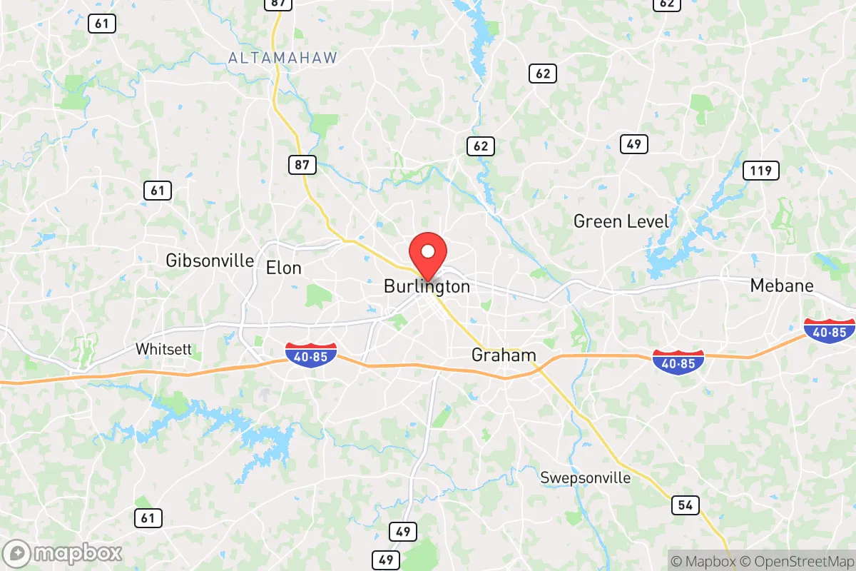
Strategic Assessment of Burlington, NC
Workable tactical position. Some exposure to population density or targets, but generally defensible in a crisis.
What does the Strategic Assessment tell us?
Our Strategic Assessment grades tactical survivability of an area. Major population centers, military targets, fallout zones, natural disasters, and border exposure all drive risk — lower exposure means a more defensible position in a crisis.
This is heavily inspired by Joel Skousen's Strategic Relocation book. Highly recommended you checkout the book ($)What does this tell us?
Our Strategic Assessment grades tactical survivability of an area. Major population centers, military targets, fallout zones, natural disasters, and border exposure all drive risk — lower exposure means a more defensible position in a crisis.
This is heavily inspired by Joel Skousen's Strategic Relocation book. Highly recommended you checkout the book ($)Strategic Pillars

Key Distances
Regional Safe Places
Below is our recommended "safe zones" in North Carolina and the surrounding area based on our strategic heuristics. For most people, it's unrealistic to live in a “safe zone” full-time due to work, family or other personal reasons. They tend to be more rural. However, many of these areas are perfect for second homes and retreat properties that double as a vacation home or even a short-term rental.


Important Note: For informational purposes only. This does not mean nothing bad ever happens in the green zones. Please use common sense. This is based on public data and modeled with AI. We tried to take a conservative approach but mistakes happen. We update this regularly as new information becomes available.
Solar Generator Recommendations
Backup power matters more here than in safer locations. We've picked three solar generators across budgets and capacity tiers — start with the budget unit if you only need a few essentials, or step up if you want to run a fridge and HVAC for days at a time.

Jackery Portable Power Station Explorer 300
Budget OptionPower on the Go: Weighing only 11 lbs, it's convenient to set up and store with book-sized foldable solar panels

BLUETTI Portable Power Station AC180
Designed for both indoor and outdoor scenarios, AC180 is highly capable as it has a robost capacity and continuous output power.

EF ECOFLOW DELTA Pro Ultra Power Station
Upgraded PickEcoFlow DELTA Pro Ultra is a whole-home energy system designed to grow with your family. Integrated with the Smart Home Panel 2, it scales to meet your evolving energy needs — keeping your home powered, intelligent, and secure through every stage of life.
We earn a commission, at no additional cost to you.
Strategic Assessment Analysis
Burlington, North Carolina, sits in a strategic sweet spot that resilience-minded relocators should take seriously: far enough from major metropolitan targets to avoid the worst of a collapse scenario, yet close enough to leverage their resources during stable times. Located in Alamance County along the I-85/40 corridor, this mid-sized city of roughly 60,000 offers a blend of manufacturing history, agricultural access, and geographic insulation that makes it a viable base for those planning for civic unrest, supply chain disruptions, or larger-scale disasters. Its position between the Piedmont Triad (Greensboro, Winston-Salem, High Point) and the Research Triangle (Raleigh-Durham-Chapel Hill) means you can tap into medical and logistical hubs when things are calm, but you’re not sitting on a primary target when things go sideways.
Geographic position and natural advantages for long-term preparedness
Burlington’s location at the edge of the Piedmont region gives it a mix of rolling hills, clay soils, and moderate climate that supports both defensive positioning and subsistence living. The city sits about 30 miles east of Greensboro and 45 miles west of Raleigh, placing it outside the immediate blast or fallout zones of those larger population centers while still being within a day’s drive of coastal evacuation routes or mountain retreats. The Haw River runs through the southern part of the county, providing a surface water source that, with proper filtration, could supplement well water in a grid-down scenario. Alamance County’s average elevation of 650 feet means you’re above most floodplains but not so high that winter weather becomes a mobility hazard. The region’s growing season runs roughly 200 days, long enough for serious gardening or small-scale farming, and the local soil—while needing amendment—can support staple crops like corn, beans, and squash. For a relocator thinking about food security, this is a meaningful advantage over more urbanized or arid parts of the state.
Risks, exposures, and proximity to fallout-relevant landmarks
No location is without vulnerabilities, and Burlington has several that a prepper-minded individual must weigh. The most obvious is its position along the I-85/40 corridor, a major east-west artery that connects the Triangle to the Triad and beyond. In a mass evacuation event—whether from a hurricane, a nuclear incident at the Harris Nuclear Plant (about 50 miles southeast near New Hill), or civil unrest in Raleigh—this highway could become a choke point or a vector for displaced populations. Burlington’s own population is modest, but Alamance County has seen steady growth, and the city’s proximity to Greensboro’s Piedmont Triad International Airport (a potential FEMA staging area or military logistics hub) could draw unwanted attention during a crisis. Additionally, the county is home to several industrial sites, including textile and chemical plants along the Haw River; a hazmat spill or fire could contaminate local water sources. On the nuclear front, the Harris plant is far enough that fallout would likely be diluted by distance, but prevailing winds from the southwest could carry particulate toward Burlington in a worst-case release. The city’s lack of natural barriers—no mountains, no major rivers acting as moats—means it’s not inherently defensible against organized threats, though rural pockets to the north and west offer better terrain for retreat.
Practical resilience for a relocator: food, water, energy, and defensibility
For someone serious about self-sufficiency, Burlington offers a workable baseline but requires deliberate upgrades. Municipal water comes from the Haw River and Lake Mackintosh, treated by the city’s water plant; in a prolonged grid failure, this system would fail within days. Well water is common in rural Alamance County, and properties with existing wells are a priority for anyone looking to avoid dependence on city infrastructure. The local power grid is served by Duke Energy, which has a mixed reliability record during storms—ice storms in 2002 and 2021 caused multi-day outages. Solar with battery backup is feasible here, given the region’s average of 217 sunny days per year, though tree cover in older neighborhoods can limit panel efficiency. Food resilience is more promising: Alamance County has over 1,200 farms, many within a 15-minute drive of downtown Burlington, producing tobacco, poultry, soybeans, and vegetables. The Piedmont Triad Farmers Market in Greensboro is a reliable source for bulk produce and livestock, and local ordinances in unincorporated areas allow for backyard chickens and small-scale animal husbandry. For defense, the terrain is gently rolling with mixed hardwood forests, offering decent concealment but limited long-range visibility. Gun laws in North Carolina are favorable for preparedness: the state has permitless concealed carry for residents 18 and older, no magazine capacity restrictions, and a Castle Doctrine that extends to vehicles and workplaces. Burlington itself has a moderate crime rate—property crime is above the national average, but violent crime is lower than in nearby Greensboro or Durham—meaning you’ll want a solid home security setup and situational awareness, especially near the I-85 corridor.
The overall strategic picture for Burlington is one of calculated compromise. It’s not a remote mountain redoubt, nor is it a fortified compound in the middle of nowhere. What it offers is a balanced position: close enough to medical and supply networks to function normally in peacetime, yet far enough from the most likely targets—Raleigh’s government infrastructure, Greensboro’s transportation hubs, the nuclear plant—to avoid being ground zero in a crisis. The city’s manufacturing base (Honda Aircraft, LabCorp, and several textile firms) provides economic stability that matters when you’re building a long-term plan, and the local political climate in Alamance County leans conservative, which aligns with the values of many in the prepper community. For a single individual or family looking to relocate with resilience in mind, Burlington deserves a serious look—but only if you’re willing to invest in well water, solar backup, and a perimeter security plan. The area won’t save you from every scenario, but it gives you a fighting chance to ride out the storm and rebuild afterward.
* Values derived from national, state, county, city and local statistics and may differ in a specific area. Last updated: 2026-05-03T20:27:45.000Z
Narrative content on this page is AI-generated and may contain mistakes. Verify any details that matter before acting on them.
ReloMaps may earn a commission from affiliate links at no extra cost to you.