Photo: Wikipedia
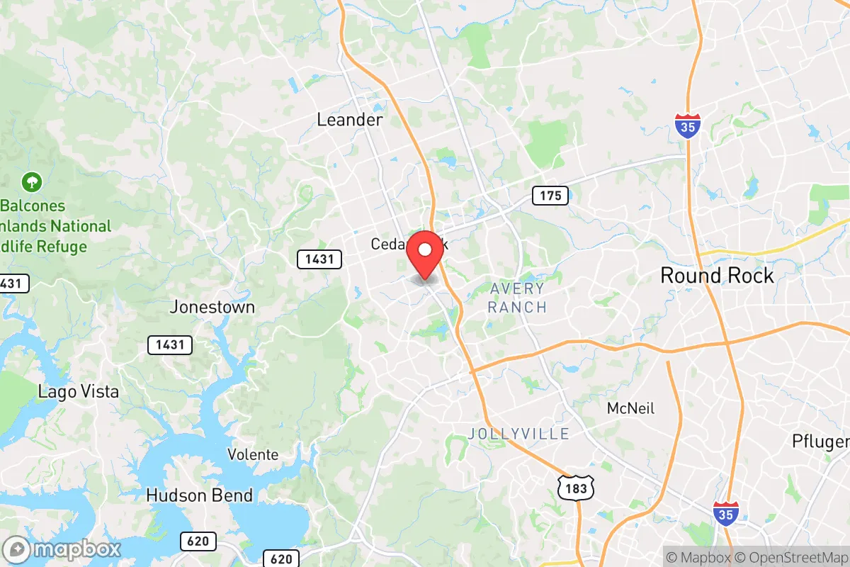
Strategic Assessment of Cedar Park, TX
Multiple tactical vulnerabilities. Population density, target proximity, or disaster risk are likely compounding. A retreat property and exit planning is required.
What does the Strategic Assessment tell us?
Our Strategic Assessment grades tactical survivability of an area. Major population centers, military targets, fallout zones, natural disasters, and border exposure all drive risk — lower exposure means a more defensible position in a crisis.
This is heavily inspired by Joel Skousen's Strategic Relocation book. Highly recommended you checkout the book ($)What does this tell us?
Our Strategic Assessment grades tactical survivability of an area. Major population centers, military targets, fallout zones, natural disasters, and border exposure all drive risk — lower exposure means a more defensible position in a crisis.
This is heavily inspired by Joel Skousen's Strategic Relocation book. Highly recommended you checkout the book ($)Strategic Pillars

Key Distances
Regional Safe Places
Below is our recommended "safe zones" in Texas and the surrounding area based on our strategic heuristics. For most people, it's unrealistic to live in a “safe zone” full-time due to work, family or other personal reasons. They tend to be more rural. However, many of these areas are perfect for second homes and retreat properties that double as a vacation home or even a short-term rental.


Important Note: For informational purposes only. This does not mean nothing bad ever happens in the green zones. Please use common sense. This is based on public data and modeled with AI. We tried to take a conservative approach but mistakes happen. We update this regularly as new information becomes available.
Solar Generator Recommendations
Backup power matters more here than in safer locations. We've picked three solar generators across budgets and capacity tiers — start with the budget unit if you only need a few essentials, or step up if you want to run a fridge and HVAC for days at a time.

Jackery Portable Power Station Explorer 300
Budget OptionPower on the Go: Weighing only 11 lbs, it's convenient to set up and store with book-sized foldable solar panels

BLUETTI Portable Power Station AC180
Designed for both indoor and outdoor scenarios, AC180 is highly capable as it has a robost capacity and continuous output power.

EF ECOFLOW DELTA Pro Ultra Power Station
Upgraded PickEcoFlow DELTA Pro Ultra is a whole-home energy system designed to grow with your family. Integrated with the Smart Home Panel 2, it scales to meet your evolving energy needs — keeping your home powered, intelligent, and secure through every stage of life.
We earn a commission, at no additional cost to you.
Strategic Assessment Analysis
Cedar Park, Texas, presents a mixed strategic picture for the conservative prepper or survivalist. Its rapid growth and proximity to Austin offer economic opportunity, but that same adjacency introduces significant vulnerabilities in a crisis scenario. The city’s resilience is not inherent; it is a function of its location on the edge of the Texas Hill Country, its relatively modern infrastructure, and the mindset of its largely conservative, family-oriented population. For a relocator weighing long-term security against short-term convenience, Cedar Park demands a clear-eyed assessment of its strengths and its very real exposure to cascading risks.
Geographic position and natural advantages for long-term survival
Cedar Park sits at the western edge of the Texas Blackland Prairie, where the terrain begins to rise into the rocky, spring-fed Hill Country. This transitional zone offers a meaningful natural advantage: the Balcones Fault Line to the west creates a natural barrier of limestone hills and steep canyons that slow movement and provide defensible terrain. The area’s elevation—roughly 1,000 feet above sea level—keeps it above the flood-prone coastal plains and reduces the risk of storm surge from a Gulf hurricane. The underlying Edwards Aquifer and the Highland Lakes chain (Lake Travis, Lake Buchanan) provide a regional water supply that is more reliable than the overstretched systems of Houston or Dallas. For a relocator, the key takeaway is that Cedar Park sits on the eastern edge of the Hill Country’s natural fortress, with access to higher ground, limestone aquifers, and a climate that supports dryland farming and rainwater catchment. The area’s limestone bedrock also means fewer basement flooding issues and more stable building foundations—a minor but real advantage for long-term infrastructure durability.
Risks, exposures, and proximity to fallout-relevant landmarks
The most glaring vulnerability is Cedar Park’s position within the Austin–Round Rock–San Marcos metropolitan corridor. The city lies roughly 15 miles northwest of downtown Austin, placing it within the blast and fallout radius of any major attack on the state capital, the University of Texas campus, or the numerous tech and government facilities along the I-35 corridor. The nearby Austin-Bergstrom International Airport and the massive semiconductor plants in Round Rock and Taylor are high-value targets for both state and non-state actors. In a scenario of civil unrest, the I-35 and SH 45 corridors become chokepoints that can be easily blocked, trapping residents between the city and the Hill Country. Additionally, the South Texas Nuclear Generating Station near Bay City is roughly 150 miles away—outside the immediate blast zone but within the range of a plume dispersal pattern under prevailing southerly winds. A catastrophic release would put Cedar Park in the path of airborne contamination, though the risk is lower than for communities closer to the coast. The area also faces periodic wildfire risk, particularly during drought years when the cedar and juniper scrub in the western hills becomes tinder. Flash flooding along creeks like the South Fork of the San Gabriel River is a recurring hazard, though modern drainage infrastructure mitigates the worst of it.
Practical resilience for a relocator: food, water, energy, and defensibility
For a relocator focused on practical self-sufficiency, Cedar Park offers a mixed bag. Water is the strongest asset: the city draws from the Highland Lakes system, and many homes have access to well water if drilled deep enough into the Edwards Aquifer. Rainwater catchment is legal and encouraged, with average annual rainfall around 34 inches—enough to support a household with proper storage. Food security is weaker. The area is suburban sprawl, with large tracts of former ranchland now covered in subdivisions and strip malls. Community gardens exist but are small; the nearest serious agricultural production is in the Blackland Prairie to the east (corn, cotton, hay) and the Hill Country to the west (goats, cattle, game). A relocator would need to secure a property with at least 1–2 acres for a serious garden and small livestock operation, which is possible in the unincorporated areas west of Cedar Park (e.g., near Lago Vista or Jonestown) but not within city limits. Energy resilience is improving: the 2021 winter storm (Uri) exposed the fragility of the Texas grid, and many residents have since installed solar panels with battery backup or invested in whole-home generators. Natural gas is widely available, and propane delivery is common for rural homes. Defensibility is the weakest link. Cedar Park is a suburban grid of cul-de-sacs and arterial roads, with no natural chokepoints or elevated positions to control movement. The city’s police force is well-funded and professional, but in a prolonged SHTF scenario, the sheer density of population (roughly 80,000 people) would make perimeter security impossible. The best strategic play is to locate on the western fringe, where the terrain offers natural barriers and fewer neighbors.
The overall strategic picture for Cedar Park is one of calculated compromise. It is not a remote survivalist redoubt, nor is it a high-risk urban kill box. For the conservative relocator who values community, economic opportunity, and a like-minded population, it offers a viable base of operations—provided you are willing to invest in hardening your property, storing supplies, and planning multiple evacuation routes west into the Hill Country. The area’s water access, moderate climate, and defensible western edge make it a reasonable choice for those who want to stay close to civilization without being consumed by it. But do not mistake convenience for security. Cedar Park’s resilience depends entirely on how seriously you take your own preparations. If you treat it as a launchpad rather than a fortress, and you have the discipline to build redundancy into your water, power, and food systems, it can serve as a solid anchor in an unstable world. If you expect the city or the county to save you, you will be disappointed. The choice is yours.
* Values derived from national, state, county, city and local statistics and may differ in a specific area. Last updated: 2026-04-19T07:21:43.000Z
Narrative content on this page is AI-generated and may contain mistakes. Verify any details that matter before acting on them.
ReloMaps may earn a commission from affiliate links at no extra cost to you.