Photo: Wikipedia
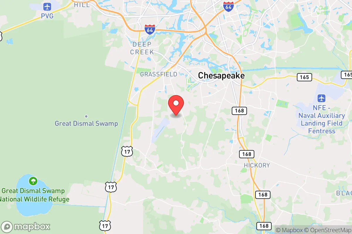
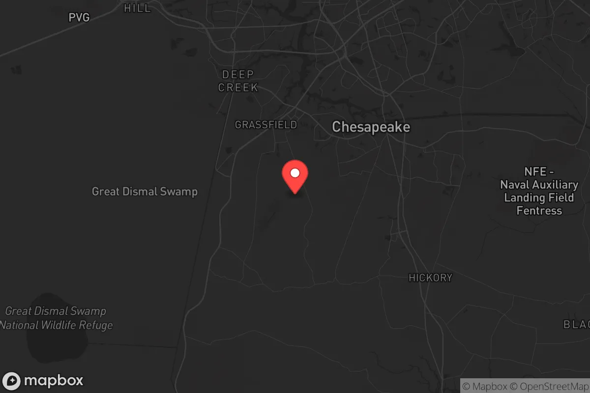
Strategic Assessment of Chesapeake, VA
Multiple tactical vulnerabilities. Population density, target proximity, or disaster risk are likely compounding. A retreat property and exit planning is required.
What does the Strategic Assessment tell us?
Our Strategic Assessment grades tactical survivability of an area. Major population centers, military targets, fallout zones, natural disasters, and border exposure all drive risk — lower exposure means a more defensible position in a crisis.
This is heavily inspired by Joel Skousen's Strategic Relocation book. Highly recommended you checkout the book ($)What does this tell us?
Our Strategic Assessment grades tactical survivability of an area. Major population centers, military targets, fallout zones, natural disasters, and border exposure all drive risk — lower exposure means a more defensible position in a crisis.
This is heavily inspired by Joel Skousen's Strategic Relocation book. Highly recommended you checkout the book ($)Strategic Pillars

Key Distances
Regional Safe Places
Below is our recommended "safe zones" in Virginia and the surrounding area based on our strategic heuristics. For most people, it's unrealistic to live in a “safe zone” full-time due to work, family or other personal reasons. They tend to be more rural. However, many of these areas are perfect for second homes and retreat properties that double as a vacation home or even a short-term rental.


Important Note: For informational purposes only. This does not mean nothing bad ever happens in the green zones. Please use common sense. This is based on public data and modeled with AI. We tried to take a conservative approach but mistakes happen. We update this regularly as new information becomes available.
Solar Generator Recommendations
Backup power matters more here than in safer locations. We've picked three solar generators across budgets and capacity tiers — start with the budget unit if you only need a few essentials, or step up if you want to run a fridge and HVAC for days at a time.

Jackery Portable Power Station Explorer 300
Budget OptionPower on the Go: Weighing only 11 lbs, it's convenient to set up and store with book-sized foldable solar panels

BLUETTI Portable Power Station AC180
Designed for both indoor and outdoor scenarios, AC180 is highly capable as it has a robost capacity and continuous output power.

EF ECOFLOW DELTA Pro Ultra Power Station
Upgraded PickEcoFlow DELTA Pro Ultra is a whole-home energy system designed to grow with your family. Integrated with the Smart Home Panel 2, it scales to meet your evolving energy needs — keeping your home powered, intelligent, and secure through every stage of life.
We earn a commission, at no additional cost to you.
Strategic Assessment Analysis
Chesapeake, Virginia, occupies a strategic position that balances access to critical infrastructure with enough physical separation from the most obvious urban collapse zones. As a prepper or survivalist evaluating relocation options, the city’s location at the southern edge of the Hampton Roads metro area offers a mix of natural buffers and logistical choke points that could work in your favor during a breakdown of civil order. The city’s geography—bounded by the Intracoastal Waterway, the Great Dismal Swamp, and the Atlantic Ocean—creates a layered defense against mass movement of people, while its proximity to Norfolk Naval Base and Langley Air Force Base means military assets are close enough to deter large-scale unrest but far enough that you aren’t living in a primary target zone. For a conservative-minded relocator concerned with societal fragility, Chesapeake provides a workable base of operations if you understand its specific vulnerabilities and plan accordingly.
Geographic position and natural advantages for long-term survival
Chesapeake’s most underrated asset is its sheer size—at over 350 square miles, it is the second-largest city by land area in Virginia, with a population density that drops sharply as you move south and east toward the Great Dismal Swamp National Wildlife Refuge. This low-density southern wedge offers the kind of rural buffer that urban collapse scenarios demand: limited road access, dense forest, and wetlands that make foot travel difficult. The city sits at the confluence of the Elizabeth River, the Albemarle and Chesapeake Canal, and the Intracoastal Waterway, meaning you have multiple waterborne escape routes if road networks become impassable. The Great Dismal Swamp itself is a 112,000-acre natural barrier that separates Chesapeake from North Carolina’s Outer Banks, creating a de facto moat against any southward movement of unrest from Norfolk or Virginia Beach. For a prepper, this means you can secure a property in the southern half of the city and have a defensible perimeter that most urban refugees would not attempt to cross. The climate is temperate enough to support year-round gardening and small-scale livestock, with a growing season that runs from April to October, and the region’s average annual rainfall of 47 inches ensures that rainwater catchment systems are viable. The Chesapeake Bay watershed provides abundant freshwater sources, including the Northwest River and several large reservoirs like Lake Drummond, though access to these is controlled and would require pre-arranged permissions or private land ownership.
Risks, exposures, and proximity to fallout-relevant landmarks
The primary strategic liability of Chesapeake is its location within the Hampton Roads metropolitan area, which houses over 1.8 million people and includes the world’s largest naval base at Norfolk. In a scenario involving mass casualty events or nuclear exchange, Norfolk Naval Base is a top-tier target for any adversary, and Chesapeake lies within the blast and fallout radius of a ground burst on the base. The prevailing winds in the region blow from the southwest, meaning fallout from a strike on Norfolk would likely drift toward the Atlantic, but a strike on the naval shipyards in Portsmouth or the ammunition depots at Yorktown could deposit radioactive material over eastern Chesapeake. Additionally, the Hampton Roads Bridge-Tunnel and the Monitor-Merrimac Memorial Bridge-Tunnel are critical chokepoints that, if damaged or blocked, would trap residents on the south side of the James River with limited egress. The city’s extensive canal and river system, while useful for escape, also means that flooding from storm surge or deliberate dam breaches could inundate low-lying neighborhoods—particularly those near the Southern Branch of the Elizabeth River. For a relocator, the takeaway is clear: avoid the northern and western edges of Chesapeake that are within 10 miles of the naval base or the Portsmouth shipyards, and focus on properties south of the Chesapeake Expressway (Route 168) where the population thins and the distance to primary targets increases. The presence of the Chesapeake Bay Bridge-Tunnel to the north is a double-edged sword—it provides a route to the Eastern Shore, but it would be a prime target for sabotage and is likely to be locked down by military checkpoints in a crisis.
Practical resilience for a relocator: food, water, energy, and defensibility
For a single individual or family looking to establish a resilient homestead, Chesapeake offers a workable mix of suburban and rural zoning that allows for self-sufficiency without being completely off-grid. The city’s agricultural zoning in the southern half permits livestock, beekeeping, and large gardens, and there are several active farming communities in the Hickory and Deep Creek areas that still operate as working farms—meaning you can integrate into a local food network rather than relying solely on your own production. The North Carolina border is 20 minutes south, giving you access to the less-regulated firearms and ammunition markets of that state, as well as a secondary supply chain for bulk food and medical supplies. Water is the most critical resource here: while municipal water is treated and reliable, a grid-down scenario would leave most of Chesapeake without pressure. The solution is to secure a property with a private well, which is common in the rural southern sections, and pair it with a hand pump or solar-powered pump. The water table in the region is high—typically 10 to 30 feet down—so well drilling is affordable and yields consistent output. For energy, the region’s moderate solar insolation (about 4.5 peak sun hours per day) supports a 5-7 kW solar array that can run a well pump, refrigeration, and communications gear, though you will need battery storage to handle the overcast winter months. Defensibility is where Chesapeake shines: the network of canals, creeks, and swamps creates natural kill zones that funnel movement along predictable roads, and the city’s police and sheriff’s departments are well-funded and have a reputation for proactive patrolling in the rural precincts. However, do not rely on law enforcement for protection in a collapse—the Hampton Roads region has a history of gang activity and drug trafficking that could metastasize into organized looting. Your best defense is to choose a property with a single access road, preferably a dead-end, and to establish a neighborhood watch or mutual assistance pact with the 5-10 closest homes. The local gun culture is strong but not extreme; you can expect most rural landowners to be armed and willing to cooperate against common threats.
The overall strategic picture for Chesapeake is one of calculated risk. You are close enough to the military and economic engines of the East Coast to benefit from their stability in normal times, but close enough to be affected by their collapse in bad ones. The city’s natural barriers, low-density southern half, and access to freshwater and farmland make it a viable long-term retreat for a prepper who is willing to invest in well water, solar power, and a defensible perimeter. The key is to position yourself south of the Intracoastal Waterway and east of the Dismal Swamp, where the population density drops below 100 people per square mile and the escape routes into rural North Carolina remain open. If you can tolerate the humidity, the mosquitoes, and the knowledge that a major naval base is 15 miles north, Chesapeake offers a realistic balance of preparedness and normalcy—a place where you can raise a family, store supplies, and wait out the storm without feeling like you are living in a bunker. For a conservative relocator who values self-reliance but does not want to disappear into the mountains, this is one of the better options on the Mid-Atlantic coast.
* Values derived from national, state, county, city and local statistics and may differ in a specific area. Last updated: 2026-05-01T18:30:05.000Z
Narrative content on this page is AI-generated and may contain mistakes. Verify any details that matter before acting on them.
ReloMaps may earn a commission from affiliate links at no extra cost to you.