
Photo: Wikipedia
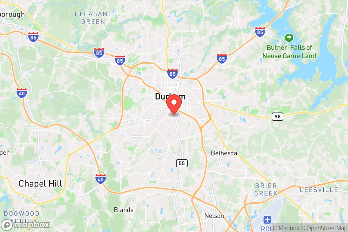
Strategic Assessment of Durham, NC
Multiple tactical vulnerabilities. Population density, target proximity, or disaster risk are likely compounding. A retreat property and exit planning is required.
What does the Strategic Assessment tell us?
Our Strategic Assessment grades tactical survivability of an area. Major population centers, military targets, fallout zones, natural disasters, and border exposure all drive risk — lower exposure means a more defensible position in a crisis.
This is heavily inspired by Joel Skousen's Strategic Relocation book. Highly recommended you checkout the book ($)What does this tell us?
Our Strategic Assessment grades tactical survivability of an area. Major population centers, military targets, fallout zones, natural disasters, and border exposure all drive risk — lower exposure means a more defensible position in a crisis.
This is heavily inspired by Joel Skousen's Strategic Relocation book. Highly recommended you checkout the book ($)Strategic Pillars

Key Distances
Regional Safe Places
Below is our recommended "safe zones" in North Carolina and the surrounding area based on our strategic heuristics. For most people, it's unrealistic to live in a “safe zone” full-time due to work, family or other personal reasons. They tend to be more rural. However, many of these areas are perfect for second homes and retreat properties that double as a vacation home or even a short-term rental.


Important Note: For informational purposes only. This does not mean nothing bad ever happens in the green zones. Please use common sense. This is based on public data and modeled with AI. We tried to take a conservative approach but mistakes happen. We update this regularly as new information becomes available.
Solar Generator Recommendations
Backup power matters more here than in safer locations. We've picked three solar generators across budgets and capacity tiers — start with the budget unit if you only need a few essentials, or step up if you want to run a fridge and HVAC for days at a time.

Jackery Portable Power Station Explorer 300
Budget OptionPower on the Go: Weighing only 11 lbs, it's convenient to set up and store with book-sized foldable solar panels

BLUETTI Portable Power Station AC180
Designed for both indoor and outdoor scenarios, AC180 is highly capable as it has a robost capacity and continuous output power.

EF ECOFLOW DELTA Pro Ultra Power Station
Upgraded PickEcoFlow DELTA Pro Ultra is a whole-home energy system designed to grow with your family. Integrated with the Smart Home Panel 2, it scales to meet your evolving energy needs — keeping your home powered, intelligent, and secure through every stage of life.
We earn a commission, at no additional cost to you.
Strategic Assessment Analysis
Durham, North Carolina, sits in a precarious strategic pocket: close enough to the Research Triangle’s economic engine to offer job security and supply access, but near enough to major population centers that it becomes a primary fallout zone during any large-scale disruption. For a relocator with a survivalist mindset, Durham’s resilience is a double-edged sword—its location provides logistical advantages, but its proximity to Raleigh, Chapel Hill, and the I-85 corridor makes it a high-risk target for civil unrest, infrastructure failure, and mass casualty events. The area’s real value lies not in its urban core, but in the surrounding rural buffer zones and the natural resources that can be leveraged if you’re willing to live on the fringe.
Geographic position and natural advantages for long-term survival
Durham’s geography is defined by the Piedmont region—rolling hills, mixed hardwood forests, and a temperate climate that supports year-round subsistence. The area sits at the headwaters of the Neuse River basin, giving residents access to surface water sources like Falls Lake and the Eno River, both of which are critical for off-grid water collection. The soil in the surrounding counties (Orange, Granville, Person) is loamy and well-drained, suitable for small-scale agriculture if you secure land outside the city limits. The moderate climate means fewer extreme weather events compared to the Gulf Coast or Tornado Alley—winter lows rarely drop below 20°F, and summer highs hover around 90°F, making it feasible to maintain a garden or greenhouse without heavy infrastructure. The region’s elevation (400–600 feet) provides natural drainage and reduces flood risk, though low-lying areas near the Eno can still see flash flooding during heavy rains. For a prepper, the key advantage is the 30–45 minute drive to rural properties in northern Durham County or southern Granville County, where land is cheaper and less densely populated. The Research Triangle’s concentration of medical facilities (Duke University Hospital, UNC Hospitals) is a double-edged asset—useful for trauma care in a stable scenario, but likely overwhelmed during a mass casualty event.
Risks, exposures, and proximity to fallout-relevant landmarks
Durham’s biggest vulnerability is its location along the I-85 corridor, a major north-south transportation artery that connects Atlanta to Washington, D.C. In any scenario involving civil unrest, supply chain disruption, or mass evacuation, I-85 becomes a chokepoint and a target. The city itself is home to Duke University and its medical complex, a high-profile institution that could attract looting, protest activity, or federal attention during a breakdown of order. The Research Triangle Park (RTP), straddling Durham and Wake counties, houses biotech and pharmaceutical facilities—valuable for medical supplies but also a potential target for sabotage or contamination events. The proximity to Raleigh (25 miles east) and Chapel Hill (10 miles southwest) means that any unrest in those cities will spill over into Durham within hours. The area’s population density (about 1,200 people per square mile in the city, but dropping to 200–300 in the rural fringe) creates a gradient of risk: the urban core is a no-go zone during a crisis, while the exurbs offer some buffer. Falls Lake Dam, located just north of Durham, is a critical infrastructure point—a breach or sabotage could flood downstream areas and disrupt water supply for the entire Triangle. Additionally, the region’s reliance on the electrical grid (Duke Energy) and natural gas pipelines makes it vulnerable to cascading failures. For a relocator, the takeaway is clear: live north or west of Durham, not east or south, to avoid the worst of the urban fallout and maintain escape routes toward the rural Piedmont.
Practical resilience for a relocator: food, water, energy, and defensibility
For a single individual or family looking to establish a resilient homestead, Durham’s surrounding areas offer a mixed bag. Water is the first concern: municipal supplies come from Falls Lake and Lake Michie, both of which are vulnerable to contamination or disruption. A well on rural property is the gold standard, but well depths in the Piedmont typically range from 100 to 300 feet, and drilling costs can run $5,000–$10,000. Rainwater collection is viable, with average annual rainfall of 45 inches, but you’ll need a large cistern system to get through dry spells. Food production is feasible on 2–5 acres of cleared land—corn, beans, squash, and leafy greens grow well, and the growing season runs from April to October. Local farmers’ markets (Durham Farmers’ Market, South Durham Farmers’ Market) are good for networking and seed sourcing in normal times, but will be among the first resources to dry up during a crisis. Energy independence is harder: solar is viable (the area gets about 200 sunny days per year), but tree cover in the rural areas means you’ll need to clear a south-facing roof or ground array. Propane backup generators are common among preppers here, and bulk propane can be stored in 500-gallon tanks. Defensibility is the weak point—the rolling terrain offers some natural cover, but the lack of natural barriers (mountains, rivers) means you’re relying on distance and perimeter security. A property with a long driveway, wooded buffer, and a single access point is ideal. The local gun culture is moderate—North Carolina is a shall-issue state for concealed carry, and Durham County has a mixed record on Second Amendment enforcement, so check local ordinances if you plan to stockpile firearms. The biggest practical advantage is the presence of multiple rural hospitals within 30 minutes (Granville Medical Center, Person Memorial Hospital) that are less likely to be overwhelmed than Duke or UNC.
Overall, Durham is a strategic compromise for the survivalist relocator. It offers the economic stability and medical infrastructure needed to thrive in a stable environment, but its location in the heart of the Research Triangle makes it a high-risk area during any large-scale disruption. The smart play is to live on the rural fringe—north or west of the city—where you can access the region’s natural resources while maintaining a buffer from the urban core. The area’s temperate climate, water availability, and agricultural potential make it a viable long-term retreat, but only if you’re willing to invest in off-grid infrastructure and accept that you’re living in the shadow of a major metropolitan zone. For a conservative-leaning individual or family looking to balance career opportunity with preparedness, Durham’s outskirts are worth a hard look—just don’t mistake the city itself for a safe haven.
* Values derived from national, state, county, city and local statistics and may differ in a specific area. Last updated: 2026-05-03T20:25:48.000Z
Narrative content on this page is AI-generated and may contain mistakes. Verify any details that matter before acting on them.
ReloMaps may earn a commission from affiliate links at no extra cost to you.