
Photo: Wikipedia
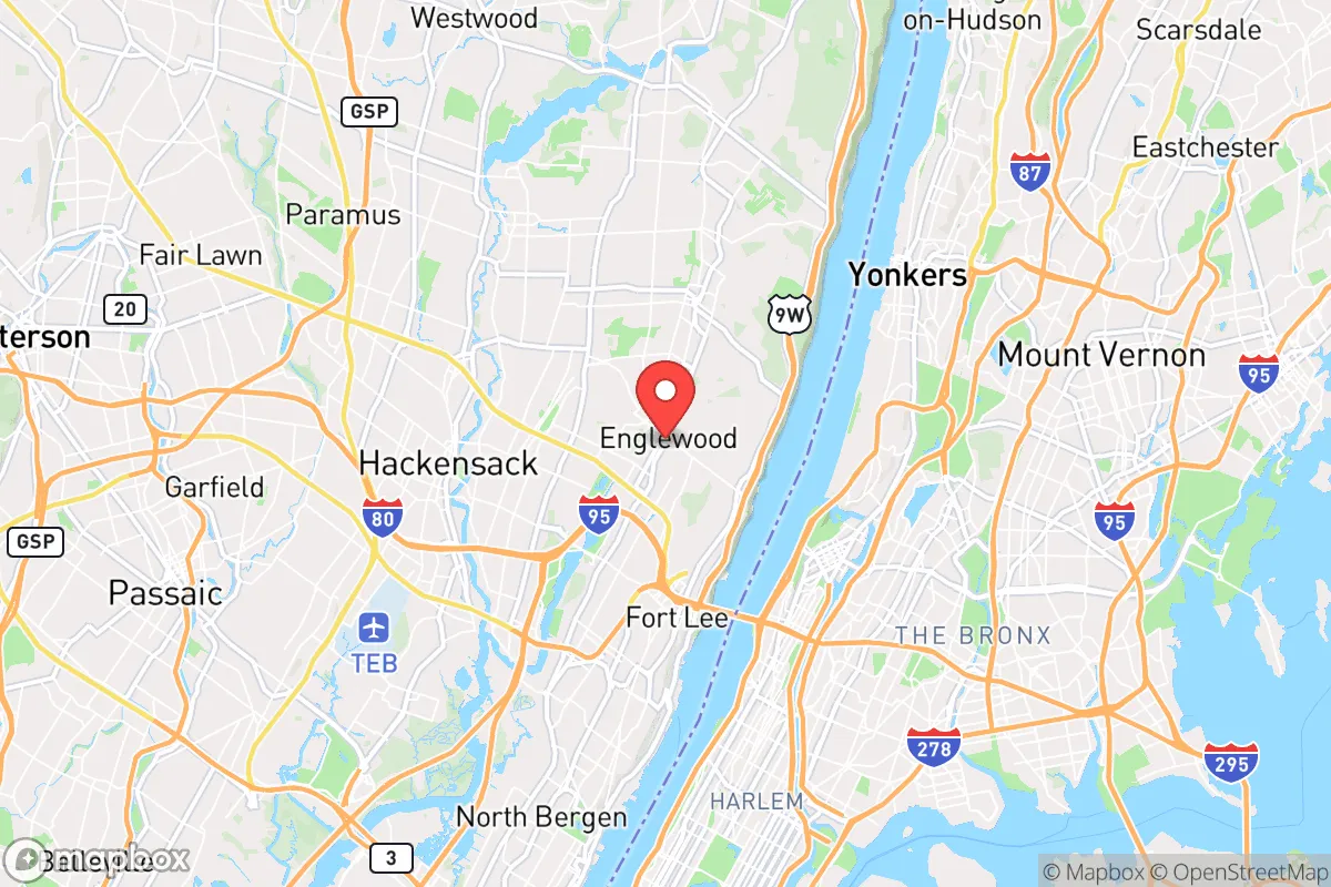
Strategic Assessment of Englewood, NJ
High tactical risk. This location is likely close to major population centers, strategic targets, or sits in a high-disaster corridor. A retreat property and careful exit planning is required.
What does the Strategic Assessment tell us?
Our Strategic Assessment grades tactical survivability of an area. Major population centers, military targets, fallout zones, natural disasters, and border exposure all drive risk — lower exposure means a more defensible position in a crisis.
This is heavily inspired by Joel Skousen's Strategic Relocation book. Highly recommended you checkout the book ($)What does this tell us?
Our Strategic Assessment grades tactical survivability of an area. Major population centers, military targets, fallout zones, natural disasters, and border exposure all drive risk — lower exposure means a more defensible position in a crisis.
This is heavily inspired by Joel Skousen's Strategic Relocation book. Highly recommended you checkout the book ($)Strategic Pillars

Key Distances
Regional Safe Places
Below is our recommended "safe zones" in New Jersey and the surrounding area based on our strategic heuristics. For most people, it's unrealistic to live in a “safe zone” full-time due to work, family or other personal reasons. They tend to be more rural. However, many of these areas are perfect for second homes and retreat properties that double as a vacation home or even a short-term rental.


Important Note: For informational purposes only. This does not mean nothing bad ever happens in the green zones. Please use common sense. This is based on public data and modeled with AI. We tried to take a conservative approach but mistakes happen. We update this regularly as new information becomes available.
Solar Generator Recommendations
Backup power matters more here than in safer locations. We've picked three solar generators across budgets and capacity tiers — start with the budget unit if you only need a few essentials, or step up if you want to run a fridge and HVAC for days at a time.

Jackery Portable Power Station Explorer 300
Budget OptionPower on the Go: Weighing only 11 lbs, it's convenient to set up and store with book-sized foldable solar panels

BLUETTI Portable Power Station AC180
Designed for both indoor and outdoor scenarios, AC180 is highly capable as it has a robost capacity and continuous output power.

EF ECOFLOW DELTA Pro Ultra Power Station
Upgraded PickEcoFlow DELTA Pro Ultra is a whole-home energy system designed to grow with your family. Integrated with the Smart Home Panel 2, it scales to meet your evolving energy needs — keeping your home powered, intelligent, and secure through every stage of life.
We earn a commission, at no additional cost to you.
Strategic Assessment Analysis
Englewood, New Jersey, sits in a precarious strategic position that demands a clear-eyed assessment for anyone serious about resilience. While its proximity to New York City offers economic opportunity, that same closeness introduces severe vulnerabilities that a prepper or survivalist must weigh carefully. The city’s location on the Palisades, with natural elevation and access to the Hudson River, provides some defensive and resource advantages, but these are offset by its position within a dense, politically volatile corridor that would be a primary target in any major disruption. For a conservative-leaning individual or family prioritizing self-reliance and security, Englewood presents a mixed bag—strong local assets paired with existential risks that cannot be ignored.
Geographic position and natural defensive advantages of Englewood
Englewood’s geography is its strongest card. Perched atop the New Jersey Palisades, the city sits roughly 200 to 300 feet above the Hudson River, offering natural elevation that provides both observation points and a degree of separation from the flood-prone lowlands. This elevation reduces the risk of storm surge from the river, a real concern for coastal communities, and gives residents a commanding view of the surrounding area—useful for situational awareness in a crisis. The city’s 5.5 square miles include a mix of dense suburban neighborhoods and wooded pockets, particularly along the western edge near Overpeck County Park, which offers 811 acres of green space, wetlands, and a lake. That parkland could serve as a buffer zone or a source of wild game and forage in a prolonged grid-down scenario, though it’s not remote enough to be a true bug-out location. The Hudson River itself is a double-edged sword: it provides a potential water source and a natural barrier to the east, but it also funnels traffic and attention from Manhattan, just 12 miles south. For a relocator, the key takeaway is that Englewood’s elevation and park access are genuine assets, but they are assets within a highly developed, population-dense region—not a wilderness retreat.
Risks, exposures, and proximity to fallout-relevant landmarks
The biggest liability for Englewood is its location within the New York metropolitan area, a region that would be a primary target for any large-scale attack, whether nuclear, biological, or conventional. Manhattan is a 20-minute drive or train ride away, and the city sits directly under major flight paths into LaGuardia and Newark airports. In a nuclear event, prevailing winds from the west would carry fallout directly over Englewood from potential strikes on New York City or even from targets in northern New Jersey like the Port Newark-Elizabeth marine terminal or the Linden natural gas storage facility. The city is also within 10 miles of the Indian Point Energy Center (though it is now decommissioned, its spent fuel pools remain a risk), and within 20 miles of the Oyster Creek nuclear plant. Beyond nuclear threats, Englewood’s dense population—over 29,000 people in a small area—means that any civil unrest, food shortage, or pandemic would amplify quickly. The city’s demographics and politics lean heavily blue; Bergen County voted 56% for Biden in 2020, and Englewood itself is a diverse, liberal-leaning community. For a conservative prepper, this means navigating a local culture that may not share your priorities around firearms, self-defense, or stockpiling. The city’s police force is professional but small (around 80 officers), and in a widespread emergency, they would be overwhelmed by the sheer volume of people fleeing the city. The nearby George Washington Bridge, just 5 miles south, would become a chokepoint of desperation in any evacuation scenario, turning local roads into parking lots.
Practical resilience for a relocator: food, water, energy, and defensibility
For someone looking to hunker down in Englewood, the practical challenges are significant but not insurmountable. Water is the first concern: the city draws from the Hackensack River via United Water, a surface source that is vulnerable to contamination from upstream industrial sites or a coordinated attack. A well is not an option for most homes in this dense suburb, so a prepper must rely on stored water, rainwater catchment (legal in New Jersey with restrictions), or filtration from the Hudson River—though that water is brackish and requires reverse osmosis or distillation to be potable. Food security is equally tricky. Englewood has a handful of grocery stores, but supply chains would snap quickly in a crisis; the city has no significant agricultural land, and community gardens are limited. Stockpiling a 3- to 6-month supply of non-perishables is essential, and that means dedicating basement or garage space, which is at a premium in older homes. Energy resilience is more promising. Many homes in Englewood are older construction with solid brick or stone foundations, and solar panel installations are feasible on south-facing roofs, though local zoning and historic district restrictions can be a hurdle. Natural gas is widely available, but the grid is fragile; a backup generator or battery system is a must. Defensibility is the hardest sell. Englewood’s street grid is open, with many homes set close to sidewalks and neighbors within earshot. A single-family home with a fenced yard offers some perimeter control, but the city’s density means that a determined group could easily surround a property. The best defensive strategy here is not to fight but to blend in and maintain a low profile—what preppers call “gray man” status. That means avoiding visible stockpiles, keeping vehicles nondescript, and building relationships with like-minded neighbors who can form a mutual assistance network. The city’s proximity to the Palisades Interstate Park also offers a potential escape route north toward less populated areas like Rockland County, New York, but that route would be contested in a mass evacuation.
The overall strategic picture for Englewood is one of calculated risk. It is not a survivalist’s paradise, nor is it a death trap. For a relocator with a conservative, prepper mindset, the city offers genuine advantages in elevation, park access, and proximity to a major waterway, all within a community that has the infrastructure to support a comfortable daily life when things are stable. But those advantages come with severe exposure to the fallout—literal and figurative—of being within striking distance of America’s most likely target. The decision to settle here hinges on your tolerance for that risk. If you are willing to invest in robust storage, energy independence, and a low-profile social strategy, Englewood can work as a base of operations. If you are looking for true isolation and defensibility, look further west into the Appalachian foothills. For the strategic-minded individual who values economic access but refuses to be caught unprepared, Englewood is a place to live with eyes wide open—and a bug-out bag packed.
* Values derived from national, state, county, city and local statistics and may differ in a specific area. Last updated: 2026-04-29T18:47:19.000Z
Narrative content on this page is AI-generated and may contain mistakes. Verify any details that matter before acting on them.
ReloMaps may earn a commission from affiliate links at no extra cost to you.