Photo: Wikipedia
Strategic Assessment of Georgetown, DE
Multiple tactical vulnerabilities. Population density, target proximity, or disaster risk are likely compounding. A retreat property and exit planning is required.
What does the Strategic Assessment tell us?
Our Strategic Assessment grades tactical survivability of an area. Major population centers, military targets, fallout zones, natural disasters, and border exposure all drive risk — lower exposure means a more defensible position in a crisis.
This is heavily inspired by Joel Skousen's Strategic Relocation book. Highly recommended you checkout the book ($)What does this tell us?
Our Strategic Assessment grades tactical survivability of an area. Major population centers, military targets, fallout zones, natural disasters, and border exposure all drive risk — lower exposure means a more defensible position in a crisis.
This is heavily inspired by Joel Skousen's Strategic Relocation book. Highly recommended you checkout the book ($)Strategic Pillars

Key Distances
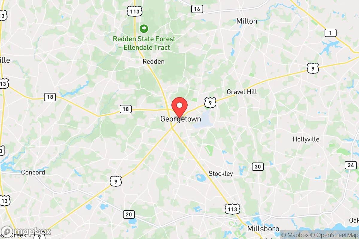
Regional Safe Places
Below is our recommended "safe zones" in Delaware and the surrounding area based on our strategic heuristics. For most people, it's unrealistic to live in a “safe zone” full-time due to work, family or other personal reasons. They tend to be more rural. However, many of these areas are perfect for second homes and retreat properties that double as a vacation home or even a short-term rental.


Important Note: For informational purposes only. This does not mean nothing bad ever happens in the green zones. Please use common sense. This is based on public data and modeled with AI. We tried to take a conservative approach but mistakes happen. We update this regularly as new information becomes available.
Solar Generator Recommendations
Backup power matters more here than in safer locations. We've picked three solar generators across budgets and capacity tiers — start with the budget unit if you only need a few essentials, or step up if you want to run a fridge and HVAC for days at a time.

Jackery Portable Power Station Explorer 300
Budget OptionPower on the Go: Weighing only 11 lbs, it's convenient to set up and store with book-sized foldable solar panels

BLUETTI Portable Power Station AC180
Designed for both indoor and outdoor scenarios, AC180 is highly capable as it has a robost capacity and continuous output power.

EF ECOFLOW DELTA Pro Ultra Power Station
Upgraded PickEcoFlow DELTA Pro Ultra is a whole-home energy system designed to grow with your family. Integrated with the Smart Home Panel 2, it scales to meet your evolving energy needs — keeping your home powered, intelligent, and secure through every stage of life.
We earn a commission, at no additional cost to you.
Strategic Assessment Analysis
Georgetown, Delaware, offers a surprisingly resilient strategic position for those prioritizing long-term preparedness and self-sufficiency, but it is not without significant trade-offs. As the county seat of Sussex County, it sits roughly 30 miles inland from the Atlantic coast and about 40 miles south of Dover, placing it outside the immediate blast and fallout zones of major metropolitan targets like Washington D.C. (roughly 120 miles west) and Philadelphia (roughly 130 miles north). This distance from primary strategic targets—combined with a low population density, a robust agricultural base, and a relatively conservative local governance structure—makes Georgetown a viable candidate for a relocation hub, provided you understand and mitigate its specific vulnerabilities.
Geographic position and natural advantages for long-term security
Georgetown’s primary strategic asset is its location within the Delmarva Peninsula, a region naturally insulated by water on three sides. The Chesapeake Bay to the west and the Atlantic Ocean to the east create a natural buffer zone that slows the movement of people and goods, which is a double-edged sword in a crisis. For a prepper, this isolation is a net positive: it reduces the likelihood of mass refugee flows from the I-95 corridor, which is only about 60 miles to the west. The area’s flat, fertile terrain supports extensive agriculture—Sussex County is a top producer of poultry, corn, and soybeans in the state—meaning local food production is viable even without a functioning supply chain. The water table is high and generally clean, with many rural properties able to access shallow wells. The climate is temperate, with no extreme cold or heat that would stress off-grid systems, and the risk of natural disasters like earthquakes or wildfires is very low. Hurricanes are a periodic threat, but Georgetown’s inland position reduces storm surge risk compared to coastal towns like Rehoboth Beach. The local government is consistently Republican-controlled, with a culture that generally respects property rights and limits zoning restrictions, which is critical for building self-sufficient infrastructure like solar arrays, rainwater catchment, or root cellars without bureaucratic pushback.
Risks, exposures, and proximity to fallout-relevant landmarks
The most serious strategic drawback of Georgetown is its proximity to the Indian River Power Plant, a coal-fired facility located about 20 miles east near Millsboro. While not a nuclear reactor, this plant is a potential target for sabotage or a secondary fallout source if disrupted. More critically, the area lies within the broader fallout risk zone of the Salem and Hope Creek nuclear plants in New Jersey, roughly 70 miles northeast across the Delaware Bay. In a worst-case scenario involving a detonation or meltdown at those facilities, prevailing winds from the northwest could carry fallout across the peninsula. Additionally, the Dover Air Force Base (40 miles north) is a high-value military target; a strike there could generate significant secondary fallout that might drift south toward Georgetown. The area is also vulnerable to a different kind of threat: the seasonal influx of tourists to the beach towns (Rehoboth, Lewes, Bethany) swells the population by hundreds of thousands in summer, creating a massive transient population that could become a desperate, mobile crisis in a sudden evacuation scenario. The main evacuation routes—Routes 9, 113, and 1—are two-lane roads that would gridlock instantly. There is no major rail line for freight or passenger movement, which limits both supply options and escape routes. The proximity to the Chesapeake & Delaware Canal (about 50 miles north) is also a concern, as it is a critical maritime chokepoint that could be targeted in a conflict, disrupting fuel and goods shipments.
Practical resilience for a relocator: food, water, energy, and defensibility
For a relocator serious about self-sufficiency, Georgetown offers a strong foundation but requires deliberate preparation. Food security is the area’s strongest suit. You can buy directly from local poultry farms (e.g., Perdue, Mountaire) and produce stands, and the growing season runs from April to October, allowing for substantial home gardening. The local farmers’ market in Georgetown is active, and the Amish and Mennonite communities in nearby Dover and Harrington provide a reliable source of non-industrial food and goods. Water is abundant but requires treatment. The water table is shallow (often 20-40 feet), so a hand pump or solar-powered well is feasible. However, agricultural runoff (poultry litter, fertilizer) is a real contamination risk; you must plan for filtration (reverse osmosis or a high-quality gravity filter) and test your well annually. Energy independence is achievable but expensive. The area gets good sun exposure (about 200 sunny days per year), so rooftop solar with battery storage is viable. Net metering is allowed, but the local utility (Delmarva Power) has been slow to interconnect in the past, so plan for a standalone system. Natural gas is not widely available in rural areas; most homes use propane or heating oil, so you should have a backup wood stove or a generator. Defensibility is moderate. Georgetown itself is a small town (about 8,000 residents) with a walkable historic core, but the surrounding area is flat, open farmland with limited natural cover. A rural property with a long driveway, a perimeter fence, and a clear line of sight is ideal. The local sheriff’s office is responsive but small; in a widespread crisis, you cannot rely on law enforcement. The community is tight-knit and generally armed—Delaware has a strong gun culture and no state-level assault weapons ban—which is a positive for mutual defense, but it also means you should expect your neighbors to be prepared and potentially wary of newcomers. The biggest practical risk is the lack of a robust local medical system. Beebe Healthcare in Lewes is the nearest trauma center, about 25 miles away, and it can be overwhelmed in a normal summer weekend. For serious emergencies, you are looking at a 45-60 minute drive to Christiana Hospital in Newark. Stockpile medical supplies and consider training in basic emergency medicine.
The overall strategic picture for Georgetown is one of moderate resilience with clear, manageable vulnerabilities. It is not a remote mountain redoubt, nor is it a hardened bunker location. What it offers is a defensible, agriculturally self-sufficient base within a conservative, low-regulation environment that is far enough from the primary targets on the East Coast to give you a fighting chance in a prolonged disruption. The key is to treat it as a semi-rural hub—not a final retreat. You need to be self-reliant for water, energy, and medical care, and you must have a plan for the seasonal population surge and the fallout risk from the nuclear plants to the north. If you can secure a property with a well, solar, and a garden, and you are willing to integrate into a community that values independence and mutual aid, Georgetown is a solid choice. If you are looking for complete isolation or a zero-risk environment, look further west into the Appalachian foothills. But for a relocator who wants to stay within a few hours of the Mid-Atlantic job market while maintaining a credible preparedness posture, Georgetown deserves serious consideration.
* Values derived from national, state, county, city and local statistics and may differ in a specific area. Last updated: 2026-04-23T03:50:32.000Z
Narrative content on this page is AI-generated and may contain mistakes. Verify any details that matter before acting on them.
ReloMaps may earn a commission from affiliate links at no extra cost to you.