Photo: Wikipedia
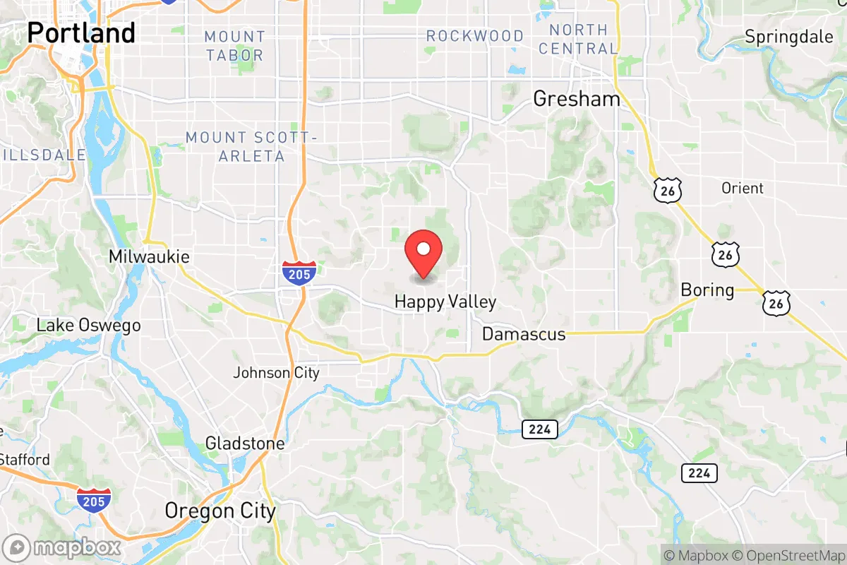
Strategic Assessment of Happy Valley, OR
Multiple tactical vulnerabilities. Population density, target proximity, or disaster risk are likely compounding. A retreat property and exit planning is required.
What does the Strategic Assessment tell us?
Our Strategic Assessment grades tactical survivability of an area. Major population centers, military targets, fallout zones, natural disasters, and border exposure all drive risk — lower exposure means a more defensible position in a crisis.
This is heavily inspired by Joel Skousen's Strategic Relocation book. Highly recommended you checkout the book ($)What does this tell us?
Our Strategic Assessment grades tactical survivability of an area. Major population centers, military targets, fallout zones, natural disasters, and border exposure all drive risk — lower exposure means a more defensible position in a crisis.
This is heavily inspired by Joel Skousen's Strategic Relocation book. Highly recommended you checkout the book ($)Strategic Pillars

Key Distances
Regional Safe Places
Below is our recommended "safe zones" in Oregon and the surrounding area based on our strategic heuristics. For most people, it's unrealistic to live in a “safe zone” full-time due to work, family or other personal reasons. They tend to be more rural. However, many of these areas are perfect for second homes and retreat properties that double as a vacation home or even a short-term rental.


Important Note: For informational purposes only. This does not mean nothing bad ever happens in the green zones. Please use common sense. This is based on public data and modeled with AI. We tried to take a conservative approach but mistakes happen. We update this regularly as new information becomes available.
Solar Generator Recommendations
Backup power matters more here than in safer locations. We've picked three solar generators across budgets and capacity tiers — start with the budget unit if you only need a few essentials, or step up if you want to run a fridge and HVAC for days at a time.

Jackery Portable Power Station Explorer 300
Budget OptionPower on the Go: Weighing only 11 lbs, it's convenient to set up and store with book-sized foldable solar panels

BLUETTI Portable Power Station AC180
Designed for both indoor and outdoor scenarios, AC180 is highly capable as it has a robost capacity and continuous output power.

EF ECOFLOW DELTA Pro Ultra Power Station
Upgraded PickEcoFlow DELTA Pro Ultra is a whole-home energy system designed to grow with your family. Integrated with the Smart Home Panel 2, it scales to meet your evolving energy needs — keeping your home powered, intelligent, and secure through every stage of life.
We earn a commission, at no additional cost to you.
Strategic Assessment Analysis
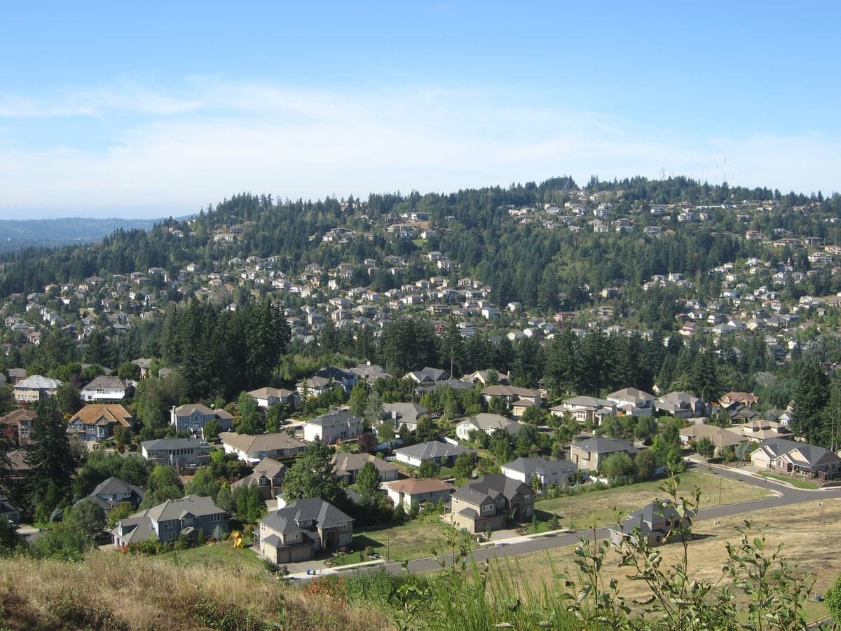
Happy Valley, Oregon, presents a mixed strategic picture for the conservative prepper. Its primary resilience advantage is its elevated geography, sitting on the Boring Lava Field volcanic plateau, which offers natural drainage and a commanding view of the Portland metro basin. However, this same proximity to a major urban center—just 12 miles from downtown Portland—creates a significant vulnerability: you are within the immediate fallout zone of a major population collapse, civil unrest, or a Cascadia Subduction Zone event. The area’s real value lies in its defensible terrain and relative isolation from the worst of Portland’s urban decay, but only if you have a plan to secure your position before the grid goes down.
Geographic position and natural advantages for long-term survival
Happy Valley’s location on the western edge of the Clackamas County highlands gives it a natural defensive posture. The city sits at an average elevation of 650 feet, with some neighborhoods cresting above 800 feet, providing clear sightlines over the Willamette Valley floor. This elevation means you are above the floodplain of the Willamette and Clackamas Rivers, a critical advantage when the Cascadia quake triggers liquefaction and inundation in lower-lying areas like Oregon City or Milwaukie. The terrain is a mix of forested ridges and open farmland, offering both cover and potential for small-scale agriculture. The Boring Lava Field, while dormant, provides a rocky substrate that drains well—useful for building root cellars or water cisterns without the mud issues of the valley floor. For a relocator, the key takeaway is that Happy Valley is a high-ground redoubt, not a lowland trap. But remember: the same hills that give you a view also funnel traffic from Portland through a few chokepoints (Highway 212/224 and 205), which will become impassable in a mass evacuation.
Risks, exposures, and proximity to fallout-relevant landmarks
The biggest strategic liability is Happy Valley’s proximity to Portland’s urban core and its associated critical infrastructure. You are within 15 miles of the Portland International Airport (PDX), the Port of Portland’s industrial terminals, and the I-5/I-205 interchange—all prime targets for civil unrest or a coordinated attack. In a Cascadia Subduction Zone earthquake (magnitude 9.0+), the entire Portland basin will experience severe shaking, with liquefaction and building collapse concentrated in the flatlands. Happy Valley’s bedrock will fare better, but you will still face 30-60 seconds of violent shaking, likely damaging older homes and knocking out power. The area is also downwind of the Columbia River Gorge, a natural wind tunnel that could carry fallout from a dirty bomb or industrial accident at the Hanford Site (upwind, 200 miles east) or from a Portland-area chemical plant. The Clackamas River, which runs along the city’s southern edge, is a water source but also a contamination vector if upstream industrial sites (e.g., the Clackamas River Water Plant) are compromised. For the prepper, the calculus is clear: Happy Valley is a good bug-out location if you are already in Portland, but a poor primary residence if you are trying to avoid the blast radius entirely. You are trading proximity to resources for proximity to risk.
Practical resilience for a relocator: food, water, energy, and defensibility
Happy Valley’s practical resilience is a mixed bag. Water is the biggest concern: the city relies on the Clackamas River via the Clackamas River Water District, which is vulnerable to earthquake damage and contamination. A well is a must for any serious prepper, but drilling into the basalt layer is expensive and uncertain—expect $15,000-$25,000 for a 300-foot well, and you may hit low-yield rock. Food is more promising: the surrounding Clackamas County farmland (e.g., Canby, Aurora) produces berries, hazelnuts, and vegetables, and you can barter with local farmers if you build relationships now. The city’s zoning allows for backyard chickens and small livestock, but HOA restrictions in many subdivisions (e.g., the Happy Valley master-planned communities) ban them—check your deed restrictions before buying. Energy is a weak point: PGE’s grid is aging and prone to outages during windstorms (the area sees 50+ mph gusts annually). Solar is viable (the region gets 150-170 sunny days per year, less than the desert but enough for a 5kW system with battery backup), but you will need a generator for the long, cloudy winter stretches. Defensibility is the area’s strongest suit: the winding, dead-end roads (e.g., 152nd Avenue, Sunnybrook Boulevard) create natural chokepoints, and the forested ridges offer concealment. However, the city’s population density (about 25,000 people in 5 square miles) means you cannot rely on isolation—your neighbors will be your first line of defense or your first threat. A well-stocked pantry, a water filtration system (Berkey or similar), and a solid perimeter plan (motion lights, cameras, reinforced doors) are non-negotiable here.
The overall strategic picture for Happy Valley is one of calculated risk. It is not a remote survivalist retreat—you are too close to Portland’s collapse zone for that. But it is a defensible, elevated position that offers a realistic chance of riding out a short-term crisis (weeks to months) if you have prepared your home and built local alliances. The conservative prepper should view Happy Valley as a transitional location: a place to establish a foothold while scouting more remote properties in the Cascades (e.g., Estacada, Government Camp) or eastern Oregon (e.g., John Day). If you are already here, your priority is hardening your home and building a network of like-minded neighbors. If you are considering a move, ask yourself: can you tolerate the risk of being within 20 miles of a major city that will become a humanitarian disaster zone in a crisis? If the answer is yes, Happy Valley’s hills and farmland offer a viable, if imperfect, base of operations. If no, look further east, past the Cascade crest, where the population thins and the grid is less fragile. Either way, the time to act is now—before the next earthquake or civil unrest event reminds everyone that geography is destiny.
* Values derived from national, state, county, city and local statistics and may differ in a specific area. Last updated: 2026-05-03T10:47:54.000Z
Narrative content on this page is AI-generated and may contain mistakes. Verify any details that matter before acting on them.
ReloMaps may earn a commission from affiliate links at no extra cost to you.