Strategic Assessment of Kaneohe, HI
Meaningful friction. Expect exposure to either population pressure, blast zones, or natural disaster risk. Consider buying a retreat property.
What does the Strategic Assessment tell us?
Our Strategic Assessment grades tactical survivability of an area. Major population centers, military targets, fallout zones, natural disasters, and border exposure all drive risk — lower exposure means a more defensible position in a crisis.
This is heavily inspired by Joel Skousen's Strategic Relocation book. Highly recommended you checkout the book ($)What does this tell us?
Our Strategic Assessment grades tactical survivability of an area. Major population centers, military targets, fallout zones, natural disasters, and border exposure all drive risk — lower exposure means a more defensible position in a crisis.
This is heavily inspired by Joel Skousen's Strategic Relocation book. Highly recommended you checkout the book ($)Strategic Pillars

Key Distances
Regional Safe Places
Below is our recommended "safe zones" in Hawaii and the surrounding area based on our strategic heuristics. For most people, it's unrealistic to live in a “safe zone” full-time due to work, family or other personal reasons. They tend to be more rural. However, many of these areas are perfect for second homes and retreat properties that double as a vacation home or even a short-term rental.


Important Note: For informational purposes only. This does not mean nothing bad ever happens in the green zones. Please use common sense. This is based on public data and modeled with AI. We tried to take a conservative approach but mistakes happen. We update this regularly as new information becomes available.
Solar Generator Recommendations
Backup power matters more here than in safer locations. We've picked three solar generators across budgets and capacity tiers — start with the budget unit if you only need a few essentials, or step up if you want to run a fridge and HVAC for days at a time.

Jackery Portable Power Station Explorer 300
Budget OptionPower on the Go: Weighing only 11 lbs, it's convenient to set up and store with book-sized foldable solar panels

BLUETTI Portable Power Station AC180
Designed for both indoor and outdoor scenarios, AC180 is highly capable as it has a robost capacity and continuous output power.

EF ECOFLOW DELTA Pro Ultra Power Station
Upgraded PickEcoFlow DELTA Pro Ultra is a whole-home energy system designed to grow with your family. Integrated with the Smart Home Panel 2, it scales to meet your evolving energy needs — keeping your home powered, intelligent, and secure through every stage of life.
We earn a commission, at no additional cost to you.
Strategic Assessment Analysis
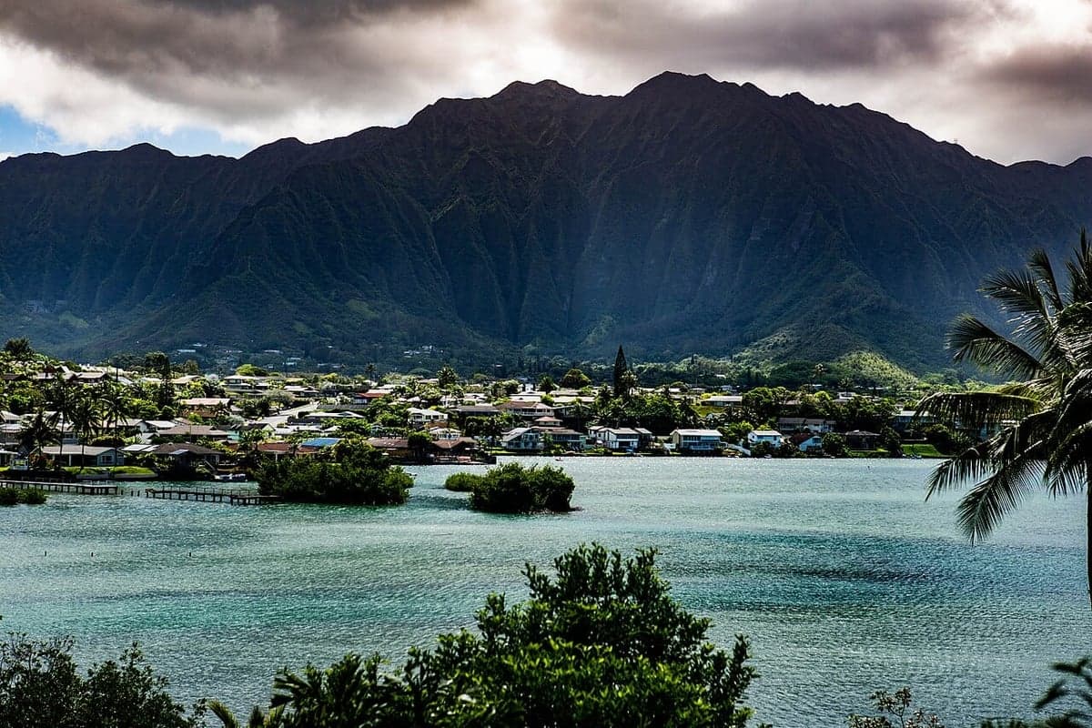
Kaneohe, located on the windward side of Oahu, presents a complex strategic picture for those prioritizing resilience and self-sufficiency. Its primary advantage is geographic isolation from the densest urban and military targets on the island, while its primary disadvantage is its position within a highly centralized, import-dependent state. For a relocator concerned with civic unrest, mass casualty events, or supply chain collapse, Kaneohe offers a mix of natural defensibility and logistical vulnerability that demands careful consideration.
Geographic position and natural advantages for long-term survival
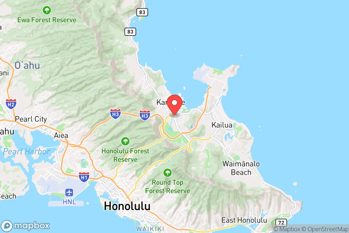
Kaneohe sits in a valley flanked by the Koolau mountain range to the west and Kaneohe Bay to the east, creating a natural funnel that limits access. The only major road in and out is the Likelike Highway (Route 63) through the Wilson Tunnel, and the Pali Highway (Route 61) via the Nuuanu Pali Tunnels. Both are single-point-of-failure chokepoints that could be blocked by a single accident, landslide, or deliberate action. In a grid-down scenario, these tunnels become impassable, effectively isolating the windward side from Honolulu and the rest of the island. This isolation is a double-edged sword: it provides a buffer against urban chaos but also means you are cut off from centralized emergency services, medical facilities, and supply lines. The surrounding mountains offer abundant rainfall, dense forest cover, and numerous streams, making water sourcing feasible with proper filtration. The bay provides access to marine protein, but the shoreline is heavily developed and lacks defensible landing zones. The area’s natural topography makes it a strong candidate for a small, self-reliant community, but not for a lone individual without pre-positioned resources.
Risks, exposures, and proximity to fallout-relevant landmarks
The most significant strategic liability for Kaneohe is its proximity to major military and government infrastructure on Oahu. Joint Base Pearl Harbor-Hickam, Hickam Air Force Base, and the Pacific Command headquarters are all within 15–20 miles as the crow flies, making them primary targets in any conflict involving state actors. The windward side is downwind of prevailing trade winds from the northeast, which means fallout from a nuclear strike on Honolulu or Pearl Harbor would likely be blown toward the ocean, but a strike on the windward side itself—or a ground burst near the Koolau range—could contaminate the entire valley. Additionally, Kaneohe is home to Marine Corps Base Hawaii (MCBH) at Kaneohe Bay, a major amphibious assault hub. In a mass casualty event or civil unrest, this base would likely be locked down and could become a target for looting or hostile forces. The area also faces natural risks: tsunamis could inundate low-lying coastal neighborhoods like Kaneohe Beach Park and Heeia, and hurricane-force winds are a recurring threat. The combination of military proximity, single-road access, and coastal exposure makes Kaneohe a moderate-risk zone for a prepper—better than downtown Honolulu, but far from ideal compared to rural areas on the Big Island or Kauai.
Practical resilience for a relocator: food, water, energy, and defensibility
For a relocator serious about self-sufficiency, Kaneohe offers some natural advantages but requires significant pre-planning. Water is the strongest asset: the windward side receives 60–80 inches of rain annually, and numerous streams (like Kaneohe Stream and Heeia Stream) flow year-round. A simple rain catchment system on a roof can provide hundreds of gallons per week, and a Berkey or Sawyer filter can make it potable. Food production is limited by the small lot sizes typical of the area—most homes sit on 5,000–10,000 square feet. You can grow taro, sweet potatoes, bananas, and papaya in the fertile volcanic soil, but you won’t achieve calorie self-sufficiency without a larger plot or community garden. The bay offers fishing, crabbing, and limu (seaweed), but overfishing and pollution from runoff are concerns. Energy independence is challenging: Hawaii’s grid is fragile and expensive, with the highest electricity rates in the nation. Solar panels are viable, but battery storage is costly, and permitting can be slow. A small propane generator with a 100-gallon tank is a more realistic backup. Defensibility is moderate: the valley’s natural bowl shape makes it easy to monitor approaches, but the dense residential layout means neighbors are close. A single-family home on a cul-de-sac near the mountains offers better security than a condo near the highway. Stockpiling ammunition, medical supplies, and non-perishable food is essential, as resupply from Honolulu will be cut off within hours of a major event. The local population is generally friendly but not prepper-oriented, so keep a low profile.
Overall, Kaneohe is a strategic compromise. It offers a defensible valley with abundant water and moderate food potential, but its proximity to major military targets and reliance on a single road make it a poor choice for a long-term bug-out location. For a single individual or family willing to invest in solar, water catchment, and a deep pantry, it can serve as a viable base for weathering short-term disruptions (weeks to months). For a full societal collapse scenario, the Big Island’s remote districts (Puna, Ka’u, or North Kohala) offer far better isolation, land availability, and lower target risk. Kaneohe is best viewed as a transitional location—a place to build skills and networks while scouting a more permanent retreat inland or on a less populated island. The key is to treat it as a staging ground, not a final destination, and to always have a secondary plan for exfiltration by boat or foot through the mountains if the tunnels close.
* Values derived from national, state, county, city and local statistics and may differ in a specific area. Last updated: 2026-04-24T00:05:56.000Z
Narrative content on this page is AI-generated and may contain mistakes. Verify any details that matter before acting on them.
ReloMaps may earn a commission from affiliate links at no extra cost to you.