
Photo: Wikipedia
Strategic Assessment of Butler County
Workable tactical position. Some exposure to population density or targets, but generally defensible in a crisis.
What does the Strategic Assessment tell us?
Our Strategic Assessment grades tactical survivability of an area. Major population centers, military targets, fallout zones, natural disasters, and border exposure all drive risk — lower exposure means a more defensible position in a crisis.
This is heavily inspired by Joel Skousen's Strategic Relocation book. Highly recommended you checkout the book ($)What does this tell us?
Our Strategic Assessment grades tactical survivability of an area. Major population centers, military targets, fallout zones, natural disasters, and border exposure all drive risk — lower exposure means a more defensible position in a crisis.
This is heavily inspired by Joel Skousen's Strategic Relocation book. Highly recommended you checkout the book ($)Strategic Pillars

Key Distances
Strategic Assessment Analysis
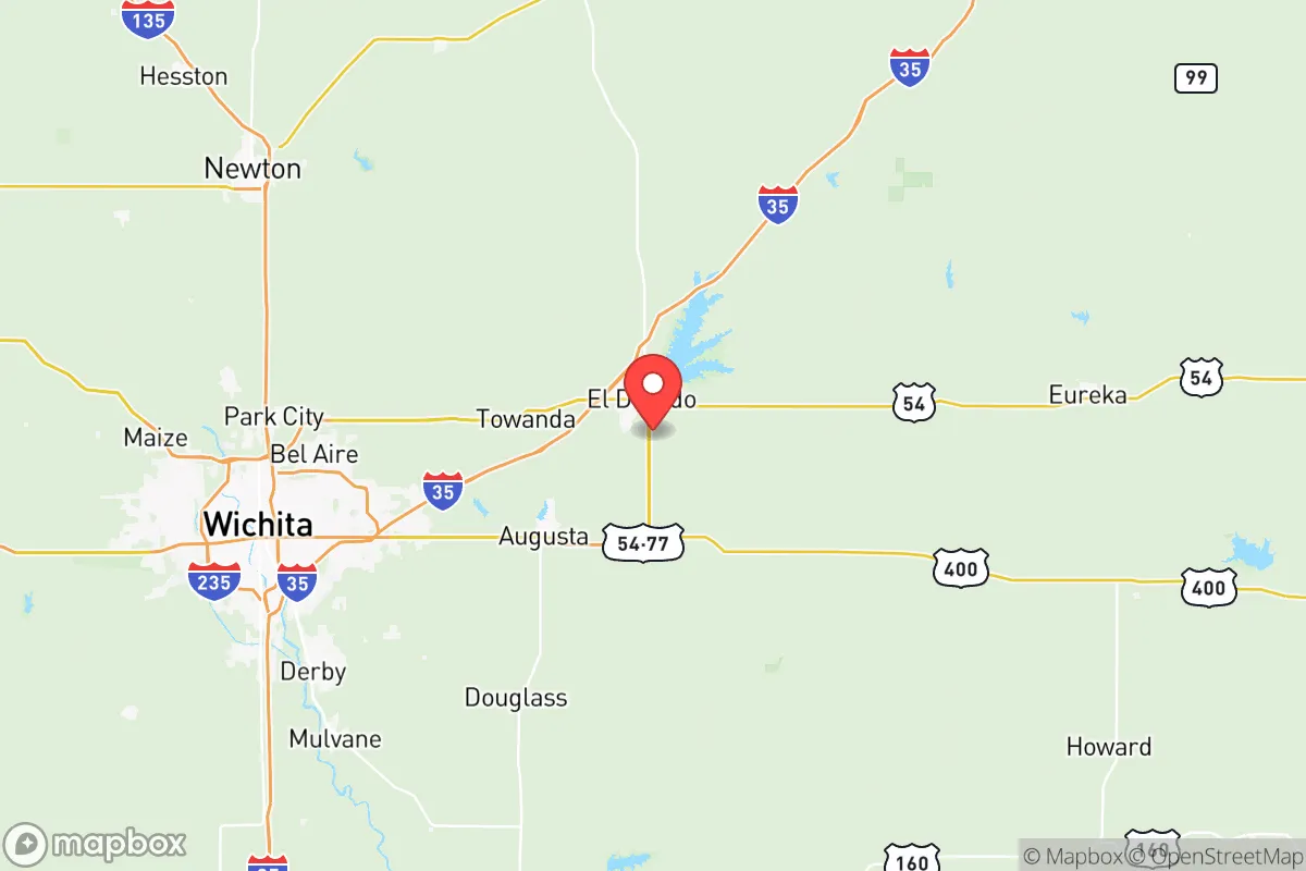
Butler County, Kansas, sits in a sweet spot that few relocation analysts talk about openly: close enough to Wichita for supply runs and medical access, but far enough out that you aren't staring down the barrel of urban unrest or a major grid-down scenario. The county's resilience profile is built on a foundation of geographic isolation, agricultural self-sufficiency, and a political culture that still values individual preparedness over government dependency. For the conservative-leaning relocator—whether a single man looking for a defensible homestead or a parent wanting to raise kids away from the chaos—this area offers a strategic buffer that most suburban counties simply cannot match.
Geographic position and natural advantages for long-term security
Butler County occupies the southeastern quadrant of Kansas, with El Dorado as its county seat and largest town, sitting roughly 30 miles east of Wichita. The county's position on the eastern edge of the Flint Hills gives it a distinct topographical advantage: rolling hills, limestone outcroppings, and deeper topsoil than the arid western plains. This isn't flat, exposed farmland where you can see your neighbor's dust trail from three miles away—it's broken terrain that provides natural cover and defensible positions. The El Dorado Lake, a 8,000-acre reservoir, is the single most critical water asset in the region, holding enough capacity to supply a sustained population through drought or infrastructure failure. The county also sits atop the Hugoton Gas Field extension, meaning natural gas extraction is a local reality, not a distant abstraction. For a relocator thinking in terms of decades, not election cycles, that energy proximity matters. The climate is continental—hot summers, cold winters—but the annual rainfall of roughly 35 inches supports dryland farming without heavy irrigation dependency. You can grow food here without a well that goes dry by July.
Risks, exposures, and proximity to fallout-relevant landmarks
No strategic assessment is honest without naming the liabilities. Butler County's primary risk vector is its proximity to Wichita, which sits just 25 miles west of the county line. Wichita is home to McConnell Air Force Base, a major tanker and intelligence hub, and the Spirit AeroSystems plant, which manufactures fuselages for Boeing and Airbus. In a major conflict scenario—say, a conventional war with a peer adversary—McConnell is a tier-one target. A ground burst at the base would put the western edge of Butler County in a moderate fallout zone, depending on wind direction. The county also lies within 150 miles of Fort Riley (Manhattan) and Whiteman Air Force Base (Missouri), both of which are strategic assets that could draw secondary strikes or ground movement. On the industrial side, the El Dorado Refinery—a 135,000-barrel-per-day facility operated by HollyFrontier—is both an asset and a liability. It's the largest refinery between the Rockies and the Mississippi, and in a grid-down or EMP scenario, it becomes a target for looting, sabotage, or accidental catastrophic release. The refinery is located just north of El Dorado proper, meaning anyone living within a five-mile radius should have a plan for rapid evacuation if things go sideways. Tornado risk is real—Butler County sits in the heart of Tornado Alley—but that's a known variable you can mitigate with a storm shelter. The bigger unknown is the Kansas City metro area, 160 miles northeast, which in a collapse scenario would push refugees south and west along I-35. Butler County is not immune to that pressure, but the Flint Hills provide a natural choke point that slows movement.
Practical resilience for a relocator: food, water, energy, and defensibility
Let's get concrete about what daily life looks like for someone who actually wants to be prepared. Water is the first concern, and Butler County delivers. El Dorado Lake is a Corps of Engineers project with a conservation pool of 98,000 acre-feet. That's enough water to support a regional population through a multi-year drought. The Walnut River runs through the county, and the Whitewater River cuts the western edge. For a relocator buying land, a well is the standard solution—most of the county sits over the Great Plains Aquifer, with yields of 10 to 50 gallons per minute at depths of 100 to 300 feet. That's not Ogallala-level volume, but it's sufficient for a family homestead with livestock and garden irrigation. Food production is where Butler County really shines. The county has over 1,200 farms covering 900,000 acres, with a mix of row crops (wheat, corn, soybeans) and cattle grazing on the native bluestem prairie. The Flint Hills are the largest remaining tallgrass prairie ecosystem in North America, and they support a robust cattle industry. For a relocator, that means local beef is available, and the knowledge base for animal husbandry is deep. The El Dorado Farmers Market operates seasonally, but the real value is in the network of small producers who sell direct—you can find raw milk, pastured eggs, and grass-fed beef within a 20-minute drive of almost any property in the county. Energy is the weak link. The grid is served by Evergy, which relies on a mix of coal, natural gas, and wind. In a prolonged outage, natural gas generators are the most practical backup, given the local extraction infrastructure. Solar is viable—the county averages 215 sunny days per year—but winter cloud cover can stretch for a week at a time, so battery storage is mandatory. Defensibility is situational. The Flint Hills provide natural observation points and limited road access in the rural eastern half of the county. The population density is roughly 40 people per square mile, which means you can own enough land to create a buffer. The Augusta and Rose Hill areas offer suburban-style neighborhoods with acreage, while the far eastern reaches near Beaumont and Cassoday are genuinely remote. For a single man or a family, the sweet spot is 10 to 40 acres in the central or eastern part of the county, with a well, a septic system, and a propane tank. That setup gives you water independence, waste autonomy, and a fuel source that doesn't rely on the grid.
The overall strategic picture for Butler County is one of calculated trade-offs. You are not in a remote mountain redoubt—you are in the Great Plains, within a day's drive of multiple strategic targets. But you are also in a county that grows its own food, stores its own water, and votes like it means it. The El Dorado area has a working-class conservatism that doesn't apologize for gun ownership, homeschooling, or church attendance. The county sheriff's office is well-funded and community-oriented. The local economy is anchored by agriculture, energy, and manufacturing—not government contracts or tech subsidies. For the relocator who understands that no location is perfectly safe, but some are significantly more survivable than others, Butler County offers a realistic middle path: close enough to civilization to function, far enough to breathe, and built on a resource base that doesn't disappear when the trucks stop running. If you are looking for a place to dig in, raise a family, and wait out the storm, this is a county worth a serious look.
* Values derived from national, state, county, city and local statistics and may differ in a specific area. Last updated: 2026-05-16T00:52:33.000Z
Narrative content on this page is AI-generated and may contain mistakes. Verify any details that matter before acting on them.
ReloMaps may earn a commission from affiliate links at no extra cost to you.