
Photo: Wikipedia
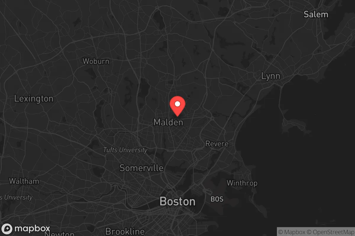
Strategic Assessment of Malden, MA
High tactical risk. This location is likely close to major population centers, strategic targets, or sits in a high-disaster corridor. A retreat property and careful exit planning is required.
What does the Strategic Assessment tell us?
Our Strategic Assessment grades tactical survivability of an area. Major population centers, military targets, fallout zones, natural disasters, and border exposure all drive risk — lower exposure means a more defensible position in a crisis.
This is heavily inspired by Joel Skousen's Strategic Relocation book. Highly recommended you checkout the book ($)What does this tell us?
Our Strategic Assessment grades tactical survivability of an area. Major population centers, military targets, fallout zones, natural disasters, and border exposure all drive risk — lower exposure means a more defensible position in a crisis.
This is heavily inspired by Joel Skousen's Strategic Relocation book. Highly recommended you checkout the book ($)Strategic Pillars

Key Distances
Regional Safe Places
Below is our recommended "safe zones" in Massachusetts and the surrounding area based on our strategic heuristics. For most people, it's unrealistic to live in a “safe zone” full-time due to work, family or other personal reasons. They tend to be more rural. However, many of these areas are perfect for second homes and retreat properties that double as a vacation home or even a short-term rental.


Important Note: For informational purposes only. This does not mean nothing bad ever happens in the green zones. Please use common sense. This is based on public data and modeled with AI. We tried to take a conservative approach but mistakes happen. We update this regularly as new information becomes available.
Solar Generator Recommendations
Backup power matters more here than in safer locations. We've picked three solar generators across budgets and capacity tiers — start with the budget unit if you only need a few essentials, or step up if you want to run a fridge and HVAC for days at a time.

Jackery Portable Power Station Explorer 300
Budget OptionPower on the Go: Weighing only 11 lbs, it's convenient to set up and store with book-sized foldable solar panels

BLUETTI Portable Power Station AC180
Designed for both indoor and outdoor scenarios, AC180 is highly capable as it has a robost capacity and continuous output power.

EF ECOFLOW DELTA Pro Ultra Power Station
Upgraded PickEcoFlow DELTA Pro Ultra is a whole-home energy system designed to grow with your family. Integrated with the Smart Home Panel 2, it scales to meet your evolving energy needs — keeping your home powered, intelligent, and secure through every stage of life.
We earn a commission, at no additional cost to you.
Strategic Assessment Analysis
Malden, Massachusetts presents a complex strategic picture for the conservative prepper or survivalist. Its proximity to Boston—just five miles north—offers immediate access to dense urban resources, but that same closeness is its primary liability in a crisis scenario. The city’s resilience is fundamentally tied to its position as a dense, inner-ring suburb of a major metropolitan hub, which means any large-scale disruption affecting Boston will ripple through Malden with little buffer. For a relocator prioritizing long-term survivability, civic stability, and geographic defensibility, Malden demands a sober assessment of trade-offs rather than a clear endorsement.
Geographic position and natural advantages in a crisis scenario
Malden sits on the Malden River, a tributary of the Mystic River, which feeds into Boston Harbor. This water access is a double-edged sword: it provides a potential source of fresh water for filtration and small-scale transport, but it also places the city within the tidal zone, meaning storm surge from a hurricane or sea-level rise event could push saltwater up the river, contaminating groundwater and complicating subsistence gardening. The terrain is generally flat to gently rolling, with the highest point around 100 feet above sea level—nowhere near enough elevation to offer a strategic vantage or escape from flood zones. The city is hemmed in by Everett, Medford, Melrose, and Revere, leaving limited natural chokepoints for defense. The primary natural advantage is the Middlesex Fells Reservation, a 2,575-acre forested area just west of Malden, which offers wood for fuel, game for hunting (deer, turkey, small mammals), and a potential fallback zone for short-term evasion. However, the Fells is crisscrossed by major roads (I-93, Route 28) and is a popular recreation area, meaning it would be quickly overrun in a collapse scenario. For a relocator, the lack of defensible terrain, combined with dense suburban sprawl, makes Malden a poor choice for a primary retreat; it could serve as a temporary staging point only if you have a vehicle and a clear exit route north toward New Hampshire.
Risks, exposures, and proximity to fallout-relevant landmarks
The most glaring risk for Malden is its proximity to Boston, which is a Tier 1 target for any nuclear exchange, electromagnetic pulse (EMP) attack, or large-scale terrorist event. Boston is home to Logan International Airport, the Port of Boston, multiple biodefense labs (including the National Emerging Infectious Diseases Laboratories at Boston University), and the regional headquarters of FEMA and the CDC. A single 300-kiloton airburst over downtown Boston would produce a fireball that vaporizes everything within a 0.5-mile radius and causes third-degree burns up to 5 miles away—Malden sits just inside that burn zone. Fallout from such a detonation would drift east-northeast with prevailing winds, meaning Malden could be spared the heaviest particulate if the wind blows offshore, but that’s a gamble no prepper should take. Beyond nuclear threats, Malden’s density (over 60,000 people in roughly 5 square miles) makes it a powder keg for civil unrest. The city has a significant immigrant population (over 40% foreign-born) and a housing stock dominated by multi-family units, which means evacuation would be chaotic and slow. The major highways—I-93, Route 1, and the Northern Strand Community Trail—are all potential chokepoints for mass exodus. Additionally, the nearby Mystic Generating Station in Everett (a natural gas and oil-fired power plant) and the Chelsea Creek oil terminal are high-value industrial targets that could release toxic plumes if struck. For a relocator, the risk profile is unacceptable for long-term habitation; Malden is a location to pass through, not settle in.
Practical resilience for a relocator: food, water, energy, and defensibility
Malden’s practical resilience is poor by prepper standards. The city’s water supply comes from the Massachusetts Water Resources Authority (MWRA), which draws from the Quabbin Reservoir—a single-point-of-failure system vulnerable to sabotage, contamination, or pump failure. In a grid-down scenario, residents would have no local wells or surface water sources that aren’t brackish or polluted; the Malden River is heavily industrialized and not potable without advanced filtration. Food resilience is equally weak. Malden has no significant agricultural land—the city’s zoning is almost entirely residential and commercial. The few community gardens (e.g., at the Malden Community Garden on Pleasant Street) are small and would be stripped within days. For energy, Malden relies on the regional grid, with no municipal solar or microgrid projects of note. Natural gas lines run throughout the city, but a prolonged outage would leave residents without heat or cooking fuel. Defensibility is the hardest sell. Malden’s street grid is a dense, interconnected web of narrow roads and tight intersections, making it easy for hostile groups to move through and hard for a single household to secure a perimeter. The housing stock is dominated by triple-deckers and small single-family homes with shared driveways—no standoff distance, no clear fields of fire, and limited storage for supplies. The nearest rural retreat options are in New Hampshire (at least 45 minutes north) or western Massachusetts (2+ hours), meaning Malden offers no buffer zone for a slow-motion collapse. A relocator would need to pre-position a bug-out vehicle with a full tank and a route planned to avoid the inevitable gridlock on I-93 and Route 1. In short, Malden is a place to live only if you have a robust plan to leave within 24 hours of a major event.
The overall strategic picture for Malden is that it is a high-risk, low-reward location for a conservative prepper or survivalist. Its advantages—proximity to Boston’s medical infrastructure, job market, and supply chains—are only relevant in a stable society. In a crisis, those same advantages become liabilities: dense population, single-point-of-failure infrastructure, and proximity to high-value targets. The city’s flat terrain and lack of defensible positions make it a poor choice for a long-term retreat, and its water and food vulnerabilities require extensive prepping that most renters or homeowners in multi-family units cannot realistically achieve. If you are single and working in Boston, Malden could serve as a temporary residence while you build a more secure property elsewhere—but it should never be your final destination. For parents, the risks are even starker: schools are crowded, evacuation routes are limited, and the social fabric is too diverse and transient to form the kind of tight-knit mutual-aid networks that matter in a collapse. The conservative prepper’s calculus should be clear: Malden is a place to avoid unless you have no other option, and even then, only with a detailed, practiced exit plan. Look north to New Hampshire or west to the Berkshires for real strategic depth.
* Values derived from national, state, county, city and local statistics and may differ in a specific area. Last updated: 2026-05-01T07:46:35.000Z
Narrative content on this page is AI-generated and may contain mistakes. Verify any details that matter before acting on them.
ReloMaps may earn a commission from affiliate links at no extra cost to you.