Photo: Wikipedia
Strategic Assessment of Marshfield, VT
Meaningful friction. Expect exposure to either population pressure, blast zones, or natural disaster risk. Consider buying a retreat property.
What does the Strategic Assessment tell us?
Our Strategic Assessment grades tactical survivability of an area. Major population centers, military targets, fallout zones, natural disasters, and border exposure all drive risk — lower exposure means a more defensible position in a crisis.
This is heavily inspired by Joel Skousen's Strategic Relocation book. Highly recommended you checkout the book ($)What does this tell us?
Our Strategic Assessment grades tactical survivability of an area. Major population centers, military targets, fallout zones, natural disasters, and border exposure all drive risk — lower exposure means a more defensible position in a crisis.
This is heavily inspired by Joel Skousen's Strategic Relocation book. Highly recommended you checkout the book ($)Strategic Pillars

Key Distances
Regional Safe Places
Below is our recommended "safe zones" in Vermont and the surrounding area based on our strategic heuristics. For most people, it's unrealistic to live in a “safe zone” full-time due to work, family or other personal reasons. They tend to be more rural. However, many of these areas are perfect for second homes and retreat properties that double as a vacation home or even a short-term rental.


Important Note: For informational purposes only. This does not mean nothing bad ever happens in the green zones. Please use common sense. This is based on public data and modeled with AI. We tried to take a conservative approach but mistakes happen. We update this regularly as new information becomes available.
Solar Generator Recommendations
Backup power matters more here than in safer locations. We've picked three solar generators across budgets and capacity tiers — start with the budget unit if you only need a few essentials, or step up if you want to run a fridge and HVAC for days at a time.

Jackery Portable Power Station Explorer 300
Budget OptionPower on the Go: Weighing only 11 lbs, it's convenient to set up and store with book-sized foldable solar panels

BLUETTI Portable Power Station AC180
Designed for both indoor and outdoor scenarios, AC180 is highly capable as it has a robost capacity and continuous output power.

EF ECOFLOW DELTA Pro Ultra Power Station
Upgraded PickEcoFlow DELTA Pro Ultra is a whole-home energy system designed to grow with your family. Integrated with the Smart Home Panel 2, it scales to meet your evolving energy needs — keeping your home powered, intelligent, and secure through every stage of life.
We earn a commission, at no additional cost to you.
Strategic Assessment Analysis
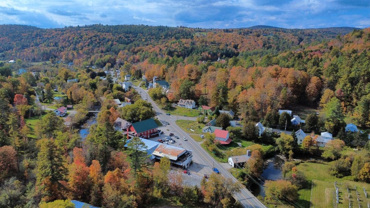
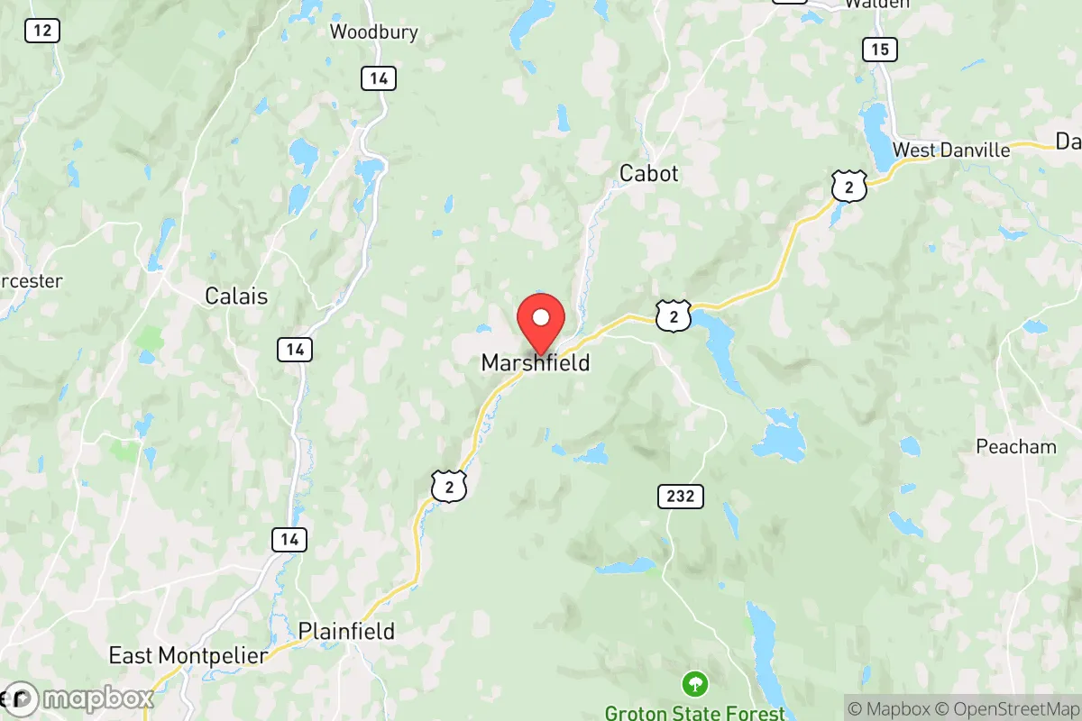
Marshfield, Vermont, offers a compelling strategic position for those prioritizing resilience and self-sufficiency in an increasingly uncertain world. Nestled in Washington County, this rural town of roughly 1,500 residents sits at a deliberate distance from major population centers—about 15 miles east of Montpelier and 45 miles from Burlington—while avoiding the immediate fallout zones of any high-value target. Its location in the Green Mountains provides natural defensibility, abundant water resources, and a climate that, while harsh in winter, discourages casual migration. For a relocator with a prepper mindset, Marshfield represents a balance of isolation and access, where the land itself becomes the first line of defense against civic unrest and systemic collapse.
Geographic position and natural advantages for long-term security
Marshfield’s geography is its primary strategic asset. The town sits in a valley carved by the Winooski River, with surrounding hills rising to elevations over 2,000 feet, offering natural observation points and chokepoints for anyone approaching from the major corridors. The area is part of the broader Northeast Kingdom region, known for its low population density—roughly 30 people per square mile in Washington County—and limited through-traffic. State Route 2 runs east-west through Marshfield, connecting to Montpelier and St. Johnsbury, but secondary roads like Marshfield Road and East Hill Road provide alternative routes that are easily monitored or blocked if needed. The proximity to Groton State Forest (over 26,000 acres) and the adjacent White River National Forest gives residents immediate access to public lands for hunting, foraging, and emergency relocation. For a conservative-leaning relocator, this terrain offers what no urban environment can: the ability to see threats coming and the space to maneuver away from them.
Risks, exposures, and proximity to fallout-relevant landmarks
No location is without vulnerabilities, and Marshfield has several that demand honest assessment. The most significant risk is its proximity to Montpelier, the state capital, which houses the Vermont State House, state government offices, and the Vermont Emergency Management headquarters. In a scenario involving civil unrest or targeted attacks on government infrastructure, Montpelier could become a focal point for chaos, and Marshfield lies just 15 miles down Route 2—close enough to feel the ripple effects but far enough to avoid direct engagement. The Burlington International Airport, 45 miles west, is a potential staging area for federal response or, in worst-case scenarios, a target for airborne threats. The Vermont Yankee nuclear plant in Vernon is roughly 80 miles south, outside the immediate fallout radius for Marshfield given prevailing winds, but still a concern for long-term contamination if a major event occurs. The town’s reliance on a single major road (Route 2) for east-west travel is a vulnerability; a bridge failure or deliberate blockage could isolate the community, though the network of dirt roads and logging trails provides secondary egress for those who know the terrain. Winter storms are the most predictable threat, with average snowfall of 80-100 inches annually, which can cut power for days and make roads impassable—a test of any prepper’s supplies and planning.
Practical resilience for a relocator: food, water, energy, and defensibility
Marshfield’s practical resilience hinges on its natural resources and the existing infrastructure of a working rural community. Water is abundant: the Winooski River runs through town, and numerous streams and springs dot the hillsides, but surface water requires filtration and boiling for safe consumption. Wells are common on private properties, with average depths of 100-200 feet, and the local geology (primarily schist and granite) provides decent groundwater yields. For food security, the area supports small-scale agriculture—hayfields, maple sugaring operations, and a handful of organic farms—but the short growing season (roughly 100-120 frost-free days) limits staple crop production. Hunting is viable: white-tailed deer, wild turkey, and black bear are present, and the nearby forests hold grouse and snowshoe hare. Fishing in the Winooski and local ponds like Molly’s Pond provides protein, but over-reliance on wild game in a crisis would deplete stocks quickly. Energy resilience is mixed: most homes use electric heat or propane, with wood stoves as a common backup. The local power grid is served by Green Mountain Power, which has a history of storm-related outages; solar panels with battery storage are a wise investment here, given the region’s 160-180 sunny days per year. Defensibility is strong: the town’s layout—scattered homes along winding roads, with dense forest cover—makes it hard for any large group to move through undetected. Neighbors tend to know each other, and the local volunteer fire department and town meeting culture foster a community that can organize quickly. For a single individual or family, the key is to arrive with skills—gardening, basic carpentry, water purification—and a willingness to integrate, because isolation in this environment without local knowledge is a liability.
The overall strategic picture for Marshfield is one of calculated trade-offs. It offers genuine advantages for those seeking to weather societal instability: low population density, abundant water, defensible terrain, and a community that values self-reliance. The downsides are real but manageable—proximity to a state capital, harsh winters, and limited agricultural potential—and they require honest preparation rather than blind optimism. For a conservative relocator who sees the country’s trajectory as unstable and wants a place where the land itself provides a buffer, Marshfield is a solid choice. It’s not a fortress, but it’s a foundation. The work of building resilience—stockpiling supplies, learning the back roads, establishing relationships with neighbors—falls on the individual. Vermont’s politics may lean left, but its geography and culture of independence align with the prepper ethos. Marshfield won’t save you from every scenario, but it gives you a fighting chance, and in the current climate, that’s more than most places can offer.
* Values derived from national, state, county, city and local statistics and may differ in a specific area. Last updated: 2026-05-01T13:30:58.000Z
Narrative content on this page is AI-generated and may contain mistakes. Verify any details that matter before acting on them.
ReloMaps may earn a commission from affiliate links at no extra cost to you.