Photo: Wikipedia
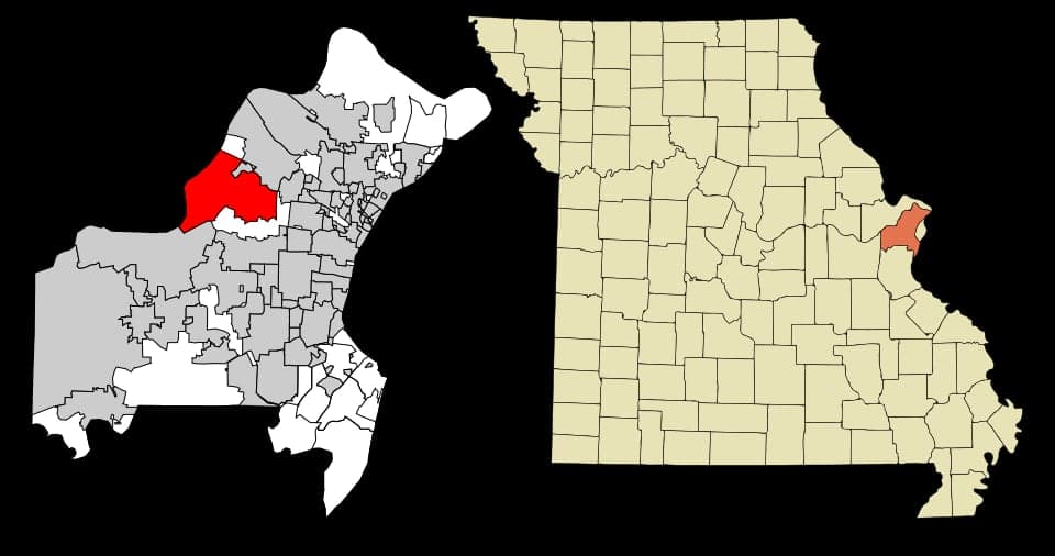
Strategic Assessment of Maryland Heights, MO
Meaningful friction. Expect exposure to either population pressure, blast zones, or natural disaster risk. Consider buying a retreat property.
What does the Strategic Assessment tell us?
Our Strategic Assessment grades tactical survivability of an area. Major population centers, military targets, fallout zones, natural disasters, and border exposure all drive risk — lower exposure means a more defensible position in a crisis.
This is heavily inspired by Joel Skousen's Strategic Relocation book. Highly recommended you checkout the book ($)What does this tell us?
Our Strategic Assessment grades tactical survivability of an area. Major population centers, military targets, fallout zones, natural disasters, and border exposure all drive risk — lower exposure means a more defensible position in a crisis.
This is heavily inspired by Joel Skousen's Strategic Relocation book. Highly recommended you checkout the book ($)Strategic Pillars

Key Distances
Regional Safe Places
Below is our recommended "safe zones" in Missouri and the surrounding area based on our strategic heuristics. For most people, it's unrealistic to live in a “safe zone” full-time due to work, family or other personal reasons. They tend to be more rural. However, many of these areas are perfect for second homes and retreat properties that double as a vacation home or even a short-term rental.


Important Note: For informational purposes only. This does not mean nothing bad ever happens in the green zones. Please use common sense. This is based on public data and modeled with AI. We tried to take a conservative approach but mistakes happen. We update this regularly as new information becomes available.
Solar Generator Recommendations
Backup power matters more here than in safer locations. We've picked three solar generators across budgets and capacity tiers — start with the budget unit if you only need a few essentials, or step up if you want to run a fridge and HVAC for days at a time.

Jackery Portable Power Station Explorer 300
Budget OptionPower on the Go: Weighing only 11 lbs, it's convenient to set up and store with book-sized foldable solar panels

BLUETTI Portable Power Station AC180
Designed for both indoor and outdoor scenarios, AC180 is highly capable as it has a robost capacity and continuous output power.

EF ECOFLOW DELTA Pro Ultra Power Station
Upgraded PickEcoFlow DELTA Pro Ultra is a whole-home energy system designed to grow with your family. Integrated with the Smart Home Panel 2, it scales to meet your evolving energy needs — keeping your home powered, intelligent, and secure through every stage of life.
We earn a commission, at no additional cost to you.
Strategic Assessment Analysis
Maryland Heights, Missouri, sits in a precarious but potentially defensible position within the St. Louis metro area, offering a mix of strategic advantages and glaring vulnerabilities for the conservative prepper or survivalist. Its location along the Missouri River and at the intersection of Interstates 270 and 70 provides critical logistical access, but its proximity to a major urban center, a nuclear research facility, and a major airport introduces significant fallout and unrest risks. For the relocator weighing long-term resilience against daily convenience, this suburb demands a hard-nosed assessment of whether its benefits outweigh its exposure to the cascading failures of a collapsing system.
Geographic position and natural advantages for long-term survival
Maryland Heights benefits from a geography that offers both water access and elevated terrain, two critical factors in a grid-down scenario. The Missouri River runs along its northern edge, providing a reliable surface water source for filtration and transport, while the surrounding bluffs and rolling hills offer natural defensibility and drainage advantages over flood-prone areas like nearby Chesterfield Valley. The city sits roughly 20 miles northwest of downtown St. Louis, placing it far enough from the urban core to avoid the immediate crush of a mass evacuation, yet close enough to exploit the region's agricultural and industrial resources. The presence of Creve Coeur Lake and the extensive parks system—including the 1,300-acre Creve Coeur Park—offers game, forage, and alternative water sources, though these public lands would become contested quickly in a crisis. The area's position in the Missouri River Valley also means moderate climate extremes, with cold winters that can stress unprepared populations but also reduce the year-round pest and disease pressures seen further south.
Risks, exposures, and proximity to fallout-relevant landmarks
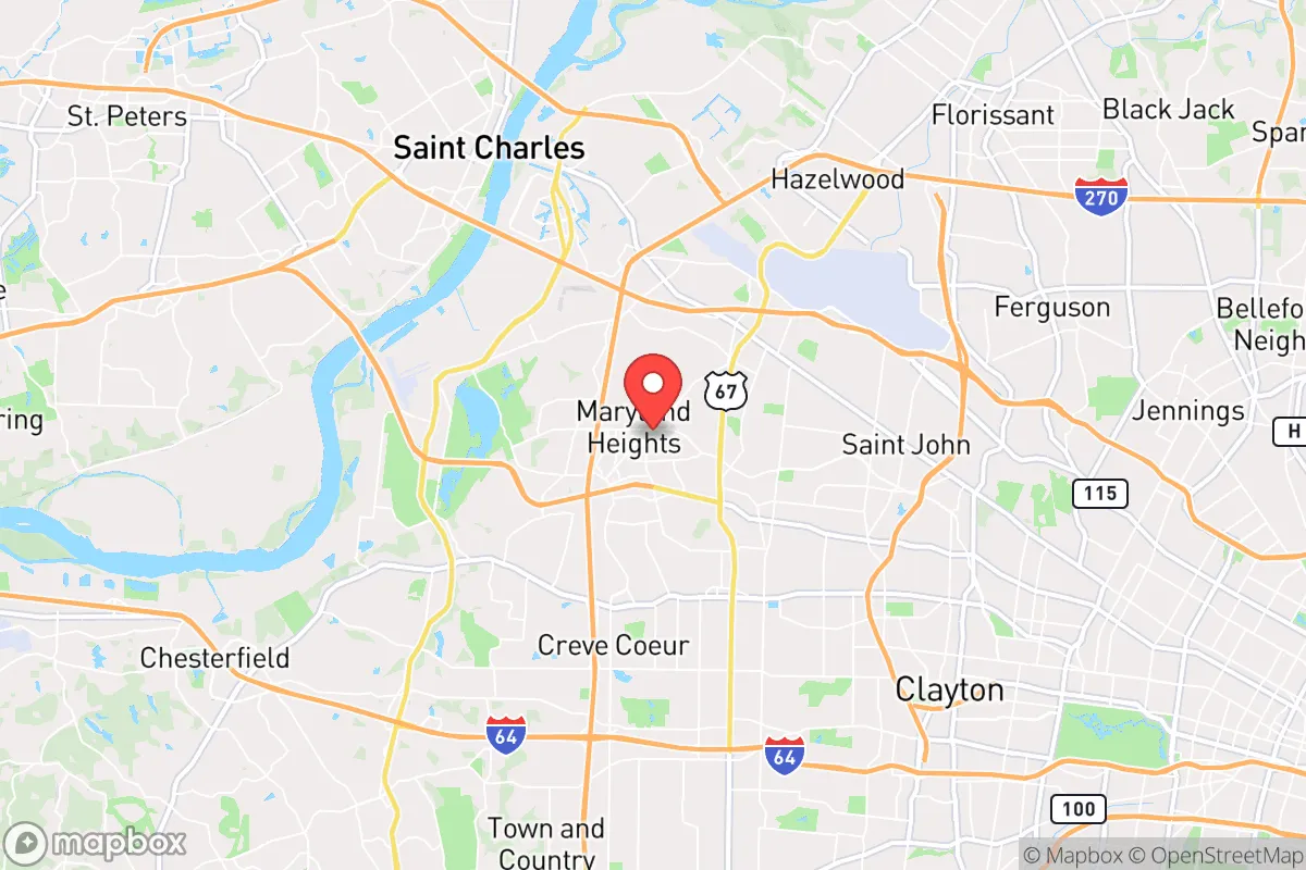
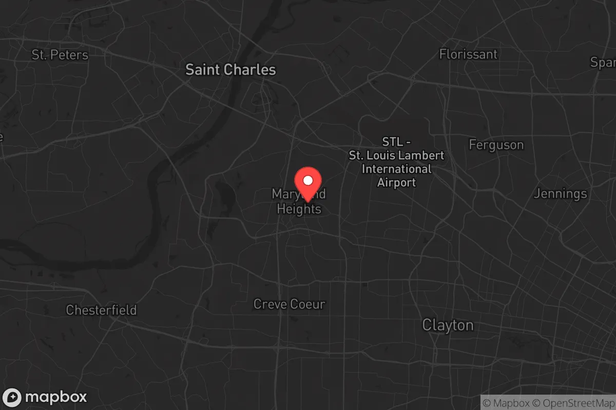
The most glaring vulnerability for Maryland Heights is its proximity to Lambert-St. Louis International Airport, located less than 10 miles to the northeast. In a mass casualty event, civil unrest, or pandemic scenario, the airport becomes a funnel for chaos—evacuees, military movements, and potential disease vectors all converge there. Worse, the city lies within 15 miles of the University of Missouri Research Reactor (MURR) in Columbia, a 10-megawatt nuclear facility that, while secure, represents a fixed target for any adversary seeking to disrupt the region. The nearby St. Louis area also hosts the West Lake Landfill, a Superfund site with radioactive waste from the Manhattan Project, which, while not an immediate explosive threat, poses long-term contamination risks if civil order collapses and site security fails. Interstate 270, which bisects the city, is a primary evacuation route for the western suburbs; in a crisis, it would become a parking lot of desperate people, making Maryland Heights a natural chokepoint for looters and refugees moving away from the city. The city's density—roughly 28,000 people in 22 square miles—means that a single point of failure, like a bridge collapse or fuel shortage, could trap residents in a zone of escalating violence and resource scarcity.
Practical resilience for a relocator: food, water, energy, and defensibility
For the individual or family serious about self-sufficiency, Maryland Heights offers a mixed bag. Water is readily available from the Missouri River, but treating it for consumption requires robust filtration systems and knowledge of chemical contaminants from upstream agricultural runoff and industrial discharge. The city's municipal water supply comes from the Missouri River via the St. Louis County Water Company, which is vulnerable to both cyberattack and physical sabotage—a hard lesson from the 2023 Missouri water main breaks that left thousands without service for days. Food security is better than in the urban core: the surrounding St. Charles and Warren counties are agricultural, with corn, soybean, and livestock operations within a 30-minute drive. However, Maryland Heights itself is a bedroom community with limited farmland; residents would need to establish relationships with rural producers or invest in suburban gardening and chicken-keeping, which HOAs and local ordinances may restrict. Energy resilience is a weak point: the grid is served by Ameren Missouri, which has faced criticism for outage response times during severe weather. Solar panels with battery storage are feasible given the area's 200+ sunny days per year, but the city's tree canopy can limit rooftop exposure. Defensibility is the hardest variable. The city's layout—a mix of subdivisions, strip malls, and office parks—offers few natural chokepoints. The bluffs along the river provide some high-ground advantage, but the flat interior and multiple road access points make perimeter defense nearly impossible without a coordinated neighborhood watch or militia-style group. The presence of a large immigrant and refugee population in the area, while not inherently negative, introduces cultural and language barriers that could complicate mutual aid networks in a breakdown scenario.
The overall strategic picture for Maryland Heights is one of calculated risk. It is not a survivalist's paradise—the proximity to St. Louis, the airport, and the nuclear research facility are hard liabilities that cannot be mitigated by stockpiling alone. However, for the relocator who cannot afford rural land in the Ozarks or the Missouri bootheel, it offers a middle ground: access to river water, agricultural hinterlands, and a population density that, while high, is still lower than the urban core. The key is to treat Maryland Heights as a staging ground, not a final redoubt. A prepper here should have a bug-out plan to the north or west—toward the Mark Twain National Forest or the Lake of the Ozarks region—and maintain a low profile to avoid becoming a target during civil unrest. The city's schools, including the well-regarded Pattonville School District, make it viable for families who want to keep children in a stable environment while preparing for the worst. But the honest assessment is that Maryland Heights is a suburb living on borrowed time, dependent on a functioning grid and civil order that cannot be guaranteed. For the conservative relocator who values community and convenience over absolute security, it may work—but only if paired with a relentless focus on mobility, self-defense, and a willingness to leave when the signs of collapse become undeniable.
* Values derived from national, state, county, city and local statistics and may differ in a specific area. Last updated: 2026-04-19T10:38:39.000Z
Narrative content on this page is AI-generated and may contain mistakes. Verify any details that matter before acting on them.
ReloMaps may earn a commission from affiliate links at no extra cost to you.