
Photo: Wikipedia
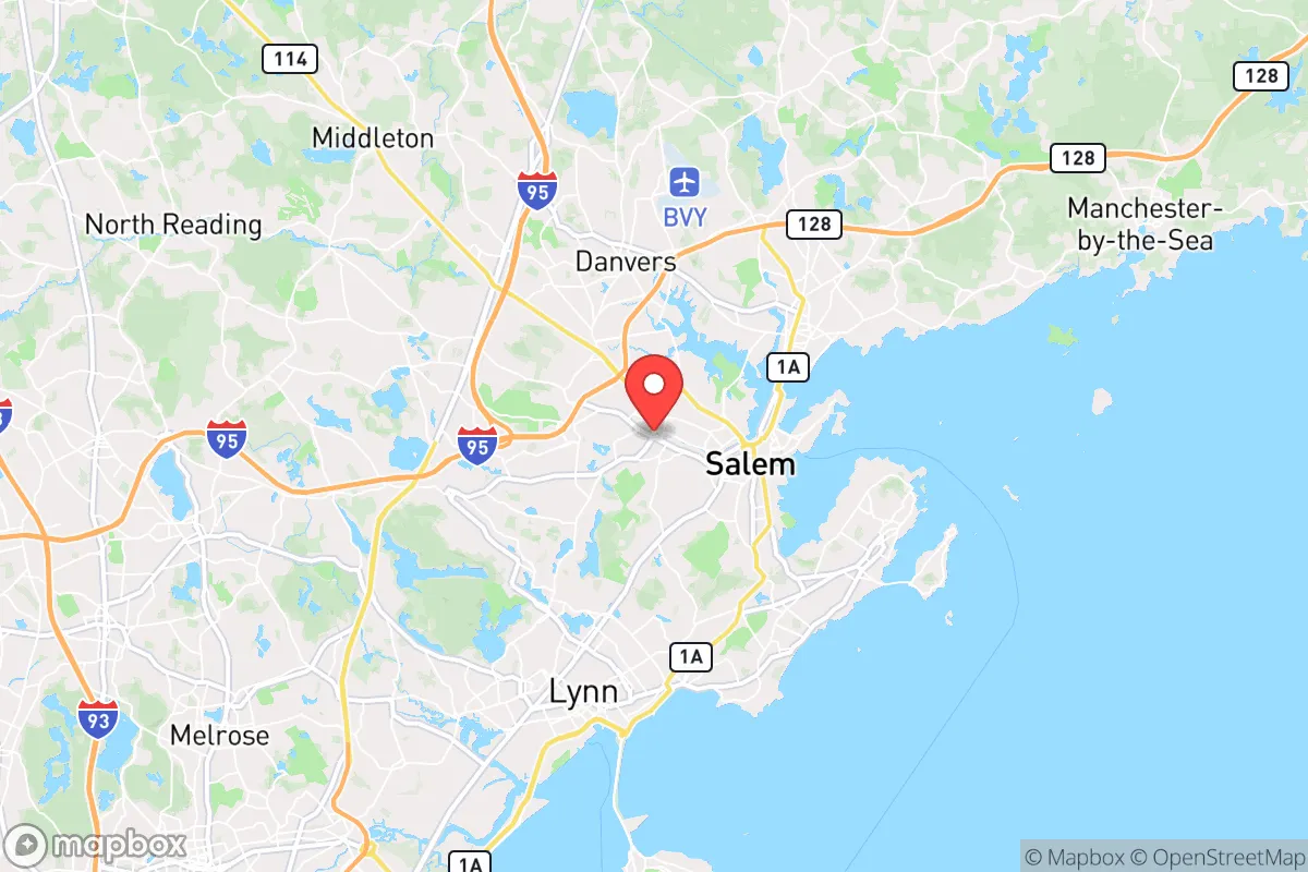
Strategic Assessment of Peabody, MA
Multiple tactical vulnerabilities. Population density, target proximity, or disaster risk are likely compounding. A retreat property and exit planning is required.
What does the Strategic Assessment tell us?
Our Strategic Assessment grades tactical survivability of an area. Major population centers, military targets, fallout zones, natural disasters, and border exposure all drive risk — lower exposure means a more defensible position in a crisis.
This is heavily inspired by Joel Skousen's Strategic Relocation book. Highly recommended you checkout the book ($)What does this tell us?
Our Strategic Assessment grades tactical survivability of an area. Major population centers, military targets, fallout zones, natural disasters, and border exposure all drive risk — lower exposure means a more defensible position in a crisis.
This is heavily inspired by Joel Skousen's Strategic Relocation book. Highly recommended you checkout the book ($)Strategic Pillars

Key Distances
Regional Safe Places
Below is our recommended "safe zones" in Massachusetts and the surrounding area based on our strategic heuristics. For most people, it's unrealistic to live in a “safe zone” full-time due to work, family or other personal reasons. They tend to be more rural. However, many of these areas are perfect for second homes and retreat properties that double as a vacation home or even a short-term rental.


Important Note: For informational purposes only. This does not mean nothing bad ever happens in the green zones. Please use common sense. This is based on public data and modeled with AI. We tried to take a conservative approach but mistakes happen. We update this regularly as new information becomes available.
Solar Generator Recommendations
Backup power matters more here than in safer locations. We've picked three solar generators across budgets and capacity tiers — start with the budget unit if you only need a few essentials, or step up if you want to run a fridge and HVAC for days at a time.

Jackery Portable Power Station Explorer 300
Budget OptionPower on the Go: Weighing only 11 lbs, it's convenient to set up and store with book-sized foldable solar panels

BLUETTI Portable Power Station AC180
Designed for both indoor and outdoor scenarios, AC180 is highly capable as it has a robost capacity and continuous output power.

EF ECOFLOW DELTA Pro Ultra Power Station
Upgraded PickEcoFlow DELTA Pro Ultra is a whole-home energy system designed to grow with your family. Integrated with the Smart Home Panel 2, it scales to meet your evolving energy needs — keeping your home powered, intelligent, and secure through every stage of life.
We earn a commission, at no additional cost to you.
Strategic Assessment Analysis
Peabody, Massachusetts, presents a mixed bag for the strategic relocator. Its location, roughly 15 miles north of Boston, offers proximity to economic opportunity but places it squarely within the blast radius of a major metropolitan target. The city’s resilience is anchored by its historic industrial base, a robust local tax base, and a geography that provides some natural buffers, but the density of the North Shore corridor and the proximity to critical infrastructure create significant vulnerabilities that must be weighed carefully.
Geographic position and natural advantages for long-term survival
Peabody sits on the southern edge of Essex County, bordered by the wetlands and tidal rivers of the Danvers River and the North River. This position offers a few genuine natural advantages. The city is not directly on the coast, which reduces—but does not eliminate—exposure to storm surge from a major hurricane. The surrounding landscape is a mix of suburban development, second-growth forest, and protected wetlands, particularly around the 2,700-acre Breakheart Reservation to the west and the 1,000-acre Lynn Woods Reservation to the south. These green spaces provide cover, potential foraging grounds, and a degree of separation from the densest population centers. The city’s elevation is modest, with the highest points around 150 feet, but the undulating terrain offers some concealment and defensible positions compared to the flat coastal plains of Revere or Lynn. The presence of the North Shore’s numerous small farms and agricultural land—especially in nearby Topsfield, Boxford, and Middleton—means that local food production is not entirely theoretical. However, Peabody itself is heavily developed; the agricultural buffer is a 15- to 30-minute drive away, not within walking distance for most residents.
Risks, exposures, and proximity to fallout-relevant landmarks
The single greatest risk for a Peabody relocator is its proximity to Boston. A nuclear detonation at Logan Airport, the Port of Boston, or the financial district would subject Peabody to severe fallout within hours, depending on wind direction. The city lies within the 10- to 20-mile zone from downtown Boston, which is the high-risk band for lethal fallout from a ground burst. Additionally, Peabody is adjacent to the Salem Harbor Station (a decommissioned coal plant but still an industrial site) and the Danvers Rail Trail corridor, which runs near the site of the 2006 Danvers chemical plant explosion. The city is also within 10 miles of the Portsmouth Naval Shipyard in Kittery, Maine, a potential target for a conventional or nuclear strike. On the infrastructure side, the Route 128/I-95 corridor runs through the western edge of Peabody, a major evacuation and supply route that would become a choke point during any crisis. The city’s own water supply comes from the Middleton Pond and the Ipswich River, both surface sources vulnerable to contamination from fallout or industrial accidents. The electrical grid is tied to the New England system, which has shown fragility during winter storms and heat waves; a prolonged outage would be a serious challenge.
Practical resilience for a relocator: food, water, energy, and defensibility
For a single individual or family looking to harden a position, Peabody offers a few practical advantages but requires significant preparation. The city has a strong local food scene—the North Shore is famous for its seafood, and there are several farmers’ markets, including the Peabody Farmers Market at the City Hall parking lot (June–October). But for long-term food security, you’ll need to establish relationships with farms in the surrounding towns or start your own garden. The soil in Peabody is a mix of sandy loam and glacial till; raised beds with imported soil are advisable. Water is the bigger concern. The municipal supply is treated and reliable in normal times, but a grid-down scenario or contamination event would leave residents dependent on stored water or nearby surface sources like the North River or Spring Pond. A well is possible on larger lots in the western part of the city, but most residential areas are on city water. Energy resilience is moderate. Peabody has no natural gas moratorium, and many homes use oil or propane for heating. Solar panels are feasible but face shading from the tree canopy in many neighborhoods. A generator and a supply of fuel are essential. Defensibility is the weakest point. Peabody is a dense, suburban city with a population of roughly 55,000. The street grid is a mix of winding roads and cul-de-sacs, but there are few natural chokepoints. The city’s police department is well-funded and professional, but during a widespread breakdown, the sheer number of people in the area would make perimeter security difficult. The best defensive strategy is to choose a home on a dead-end road near the Breakheart Reservation or the Lynn Woods, where you have a natural barrier on one side and limited access points.
The overall strategic picture for Peabody is one of calculated risk. It is not a survivalist’s paradise—the population density, proximity to Boston, and reliance on vulnerable infrastructure are real liabilities. But for someone who needs to remain within commuting distance of Boston for work or family, and who is willing to invest in serious preparations—a well-stocked pantry, a water filtration system, a generator, and a solid security plan—Peabody offers a better baseline than many inner-ring suburbs. The city’s tax base is stable, the schools are decent, and the local government is competent. The key is to treat Peabody as a base of operations, not a final redoubt. Have a bug-out plan for the rural areas of New Hampshire or Maine, and keep your vehicle fueled and your go-bag packed. In a world where the threats are real and the margins are thin, Peabody is a place you can hold for a while—but you need to know when to leave.
* Values derived from national, state, county, city and local statistics and may differ in a specific area. Last updated: 2026-04-19T10:18:06.000Z
Narrative content on this page is AI-generated and may contain mistakes. Verify any details that matter before acting on them.
ReloMaps may earn a commission from affiliate links at no extra cost to you.