Photo: Wikipedia
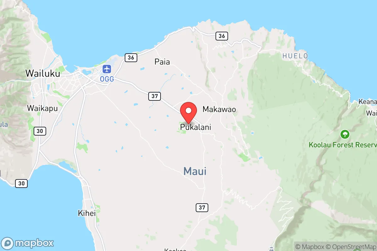
Strategic Assessment of Pukalani, HI
Strong survivability profile. Good buffer from population centers, with manageable environmental and tactical risks.
What does the Strategic Assessment tell us?
Our Strategic Assessment grades tactical survivability of an area. Major population centers, military targets, fallout zones, natural disasters, and border exposure all drive risk — lower exposure means a more defensible position in a crisis.
This is heavily inspired by Joel Skousen's Strategic Relocation book. Highly recommended you checkout the book ($)What does this tell us?
Our Strategic Assessment grades tactical survivability of an area. Major population centers, military targets, fallout zones, natural disasters, and border exposure all drive risk — lower exposure means a more defensible position in a crisis.
This is heavily inspired by Joel Skousen's Strategic Relocation book. Highly recommended you checkout the book ($)Strategic Pillars

Key Distances
Regional Safe Places
Below is our recommended "safe zones" in Hawaii and the surrounding area based on our strategic heuristics. For most people, it's unrealistic to live in a “safe zone” full-time due to work, family or other personal reasons. They tend to be more rural. However, many of these areas are perfect for second homes and retreat properties that double as a vacation home or even a short-term rental.


Important Note: For informational purposes only. This does not mean nothing bad ever happens in the green zones. Please use common sense. This is based on public data and modeled with AI. We tried to take a conservative approach but mistakes happen. We update this regularly as new information becomes available.
Solar Generator Recommendations
Backup power matters more here than in safer locations. We've picked three solar generators across budgets and capacity tiers — start with the budget unit if you only need a few essentials, or step up if you want to run a fridge and HVAC for days at a time.

Jackery Portable Power Station Explorer 300
Budget OptionPower on the Go: Weighing only 11 lbs, it's convenient to set up and store with book-sized foldable solar panels

BLUETTI Portable Power Station AC180
Designed for both indoor and outdoor scenarios, AC180 is highly capable as it has a robost capacity and continuous output power.

EF ECOFLOW DELTA Pro Ultra Power Station
Upgraded PickEcoFlow DELTA Pro Ultra is a whole-home energy system designed to grow with your family. Integrated with the Smart Home Panel 2, it scales to meet your evolving energy needs — keeping your home powered, intelligent, and secure through every stage of life.
We earn a commission, at no additional cost to you.
Strategic Assessment Analysis
Pukalani, situated on the gentle upcountry slopes of Maui, offers a strategic blend of isolation and accessibility that appeals to those prioritizing resilience in an increasingly uncertain world. Its elevation—roughly 1,400 feet above sea level—provides a natural buffer against coastal threats like tsunamis and storm surges, while its location on the island’s interior reduces exposure to the immediate fallout of a major port or airport incident. For a relocator with a prepper mindset, Pukalani represents a defensible, self-contained enclave that leverages Hawaii’s geographic remoteness as a first line of defense against national-scale disruptions.
Geographic position and natural advantages for long-term security
Pukalani’s position on the western slope of Haleakalā places it in a sweet spot for both climate and security. The area enjoys consistent trade winds that moderate temperatures year-round, rarely exceeding 85°F or dropping below 55°F, which reduces the strain on energy and water systems during a grid-down scenario. The surrounding agricultural land—much of it zoned for conservation or farming—limits dense development, meaning fewer neighbors to compete with for resources in a crisis. The town sits roughly 15 miles from Kahului, the island’s commercial hub, close enough to access supplies in normal times but far enough to avoid the chaos of a major evacuation or civil unrest event. The natural terrain, with its rolling hills and limited road access, creates chokepoints that could be monitored or defended if needed, a factor often overlooked by those focused solely on coastal living.
Risks, exposures, and proximity to potential fallout zones
No location is without vulnerabilities, and Pukalani’s primary risks stem from its island context and proximity to key infrastructure. Kahului Harbor, about 20 miles away, is the lifeblood of Maui’s supply chain—and a prime target for disruption during a national crisis, whether from cyberattacks, labor strikes, or military escalation. The Kahului Airport, also nearby, could become a focal point for mass evacuation attempts or a vector for disease spread in a pandemic scenario. While Pukalani itself is not a direct target, the collapse of either facility would sever the island’s connection to the mainland, forcing residents to rely entirely on local resources. Volcanic hazards are minimal at this elevation—lava flows from Haleakalā are unlikely to reach the area—but the island’s isolation means that a major earthquake or hurricane could disrupt power and water for weeks. The 2023 Lahaina fires, though on the opposite side of the island, serve as a stark reminder that Maui’s emergency response systems can be overwhelmed quickly, especially when roads are blocked or communications fail.
Practical resilience for a relocator: food, water, energy, and defensibility
For a relocator serious about self-sufficiency, Pukalani offers a foundation that many mainland suburbs lack. The upcountry climate supports year-round gardening—avocados, citrus, bananas, and leafy greens thrive with minimal input—and the area’s agricultural zoning means raising chickens or goats is feasible on most residential lots. Water is the critical variable: Pukalani relies on a mix of municipal supply and private catchment systems. Homes with catchment tanks, common in the area, provide a buffer against municipal outages, but a long drought could strain even these. Rainwater harvesting is a must for any prepper here, and the average annual rainfall of 40–60 inches makes it viable. Solar power is a no-brainer given the near-constant sunshine, and many homes already have panels installed, though battery storage is essential for nighttime and cloudy periods. Defensibility is a mixed bag: the town’s layout—scattered subdivisions along narrow, winding roads—makes it hard for outsiders to navigate, but also limits escape routes. The main arteries, like Kula Highway and Haleakalā Highway, can be blocked by a single accident or landslide, so having multiple exit plans and a well-stocked vehicle is non-negotiable. The local community is tight-knit, with a strong sense of neighborly reciprocity, but newcomers should invest in building relationships early—trust is a currency that can’t be stockpiled.
From a strategic standpoint, Pukalani is a solid choice for those who value geographic isolation and a temperate climate but are willing to accept the trade-offs of island life. Its distance from major mainland targets—military bases, financial centers, population-dense corridors—makes it a low-priority zone in a national crisis, but its dependence on imported goods and single-point infrastructure (the harbor, the airport) introduces fragility that must be planned for. The area’s conservative-leaning culture, with a strong emphasis on self-reliance and family, aligns well with a prepper mindset, but the high cost of living and limited job market mean that financial resilience is just as important as physical preparedness. For a single individual or a family willing to invest in water storage, solar backup, and community ties, Pukalani offers a defensible, low-drama base of operations in a world that seems increasingly prone to shocks. Just don’t expect to go it alone—Hawaii’s small-island dynamics mean that cooperation, not isolation, is the real key to long-term survival here.
* Values derived from national, state, county, city and local statistics and may differ in a specific area. Last updated: 2026-04-30T14:27:52.000Z
Narrative content on this page is AI-generated and may contain mistakes. Verify any details that matter before acting on them.
ReloMaps may earn a commission from affiliate links at no extra cost to you.