Photo: Wikipedia
Strategic Assessment of Tea, SD
Workable tactical position. Some exposure to population density or targets, but generally defensible in a crisis.
What does the Strategic Assessment tell us?
Our Strategic Assessment grades tactical survivability of an area. Major population centers, military targets, fallout zones, natural disasters, and border exposure all drive risk — lower exposure means a more defensible position in a crisis.
This is heavily inspired by Joel Skousen's Strategic Relocation book. Highly recommended you checkout the book ($)What does this tell us?
Our Strategic Assessment grades tactical survivability of an area. Major population centers, military targets, fallout zones, natural disasters, and border exposure all drive risk — lower exposure means a more defensible position in a crisis.
This is heavily inspired by Joel Skousen's Strategic Relocation book. Highly recommended you checkout the book ($)Strategic Pillars

Key Distances
Regional Safe Places
Below is our recommended "safe zones" in South Dakota and the surrounding area based on our strategic heuristics. For most people, it's unrealistic to live in a “safe zone” full-time due to work, family or other personal reasons. They tend to be more rural. However, many of these areas are perfect for second homes and retreat properties that double as a vacation home or even a short-term rental.


Important Note: For informational purposes only. This does not mean nothing bad ever happens in the green zones. Please use common sense. This is based on public data and modeled with AI. We tried to take a conservative approach but mistakes happen. We update this regularly as new information becomes available.
Solar Generator Recommendations
Backup power matters more here than in safer locations. We've picked three solar generators across budgets and capacity tiers — start with the budget unit if you only need a few essentials, or step up if you want to run a fridge and HVAC for days at a time.

Jackery Portable Power Station Explorer 300
Budget OptionPower on the Go: Weighing only 11 lbs, it's convenient to set up and store with book-sized foldable solar panels

BLUETTI Portable Power Station AC180
Designed for both indoor and outdoor scenarios, AC180 is highly capable as it has a robost capacity and continuous output power.

EF ECOFLOW DELTA Pro Ultra Power Station
Upgraded PickEcoFlow DELTA Pro Ultra is a whole-home energy system designed to grow with your family. Integrated with the Smart Home Panel 2, it scales to meet your evolving energy needs — keeping your home powered, intelligent, and secure through every stage of life.
We earn a commission, at no additional cost to you.
Strategic Assessment Analysis
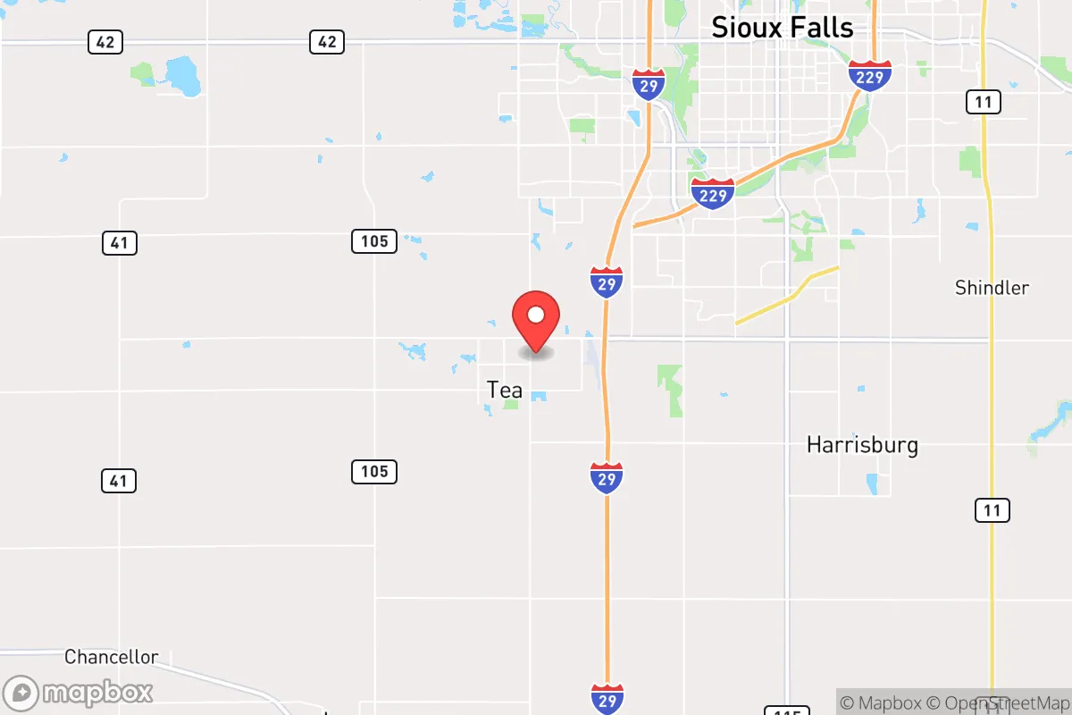
Tea, South Dakota, offers a compelling strategic position for those prioritizing resilience and self-sufficiency in an increasingly uncertain national landscape. Located just 15 minutes southwest of Sioux Falls, this small town of roughly 5,000 residents provides a rare combination: proximity to a major regional hub for supply runs and medical access, yet enough distance to avoid the immediate fallout of urban unrest, mass casualty events, or infrastructure collapse. The area's low population density, strong agricultural base, and conservative community ethos make it a viable base for a prepared relocator, but its proximity to a growing metro area and a major interstate corridor demands careful risk assessment.
Geographic position and natural advantages for long-term security
Tea sits in the heart of the Upper Midwest, a region historically insulated from the worst of coastal disasters, both natural and man-made. The town is situated on the relatively flat, fertile plains of Lincoln County, with the Big Sioux River running nearby. This geography offers several strategic benefits: abundant freshwater access via the river and local aquifers, fertile soil for small-scale food production, and a climate that supports four distinct seasons without the extreme wildfire or hurricane risks found in other parts of the country. The area's elevation and inland position mean it is not a primary target for sea-level rise or storm surge, and the region's low seismic activity eliminates earthquake concerns. For a prepper, the land itself is a resource—affordable acreage is still available within a 15-minute drive of town, allowing for private gardens, rainwater catchment, and off-grid energy installations without drawing attention. The surrounding countryside is dotted with small family farms and rural homesteads, creating a network of like-minded individuals who value self-reliance and community mutual aid, a key factor in weathering prolonged disruptions.
Risks, exposures, and proximity to fallout-relevant landmarks
The most significant vulnerability for Tea is its proximity to Sioux Falls, a city of over 200,000 people that serves as a regional economic and transportation hub. In a scenario involving civil unrest, mass casualty events, or a major disaster, Sioux Falls could become a source of cascading problems: overwhelmed hospitals, fuel shortages, supply chain breakdowns, and population displacement. Interstate 29, which runs just east of Tea, is a primary north-south corridor connecting Canada to Kansas City; in a crisis, this road could become a choke point for refugees or a target for disruption. Additionally, the nearby Sioux Falls Regional Airport and the Joe Foss Field Air National Guard base are potential military or logistical targets in a conflict scenario. While Tea itself is not a high-value target, its proximity to these assets means that secondary effects—such as roadblocks, military checkpoints, or electromagnetic pulse (EMP) effects on the power grid—could impact the area. The town's reliance on the regional power grid and centralized water treatment facilities is another exposure; a prolonged grid-down event would require residents to have independent power generation and water storage. The flat terrain, while agriculturally productive, offers limited natural defensibility; a prepared relocator should consider properties with tree lines, drainage ditches, or other natural barriers to create a layered security perimeter.
Practical resilience for a relocator: food, water, energy, and defensibility
For a single individual or family looking to establish a resilient homestead, Tea's practical advantages are substantial. Food security is a strong point: the surrounding region is one of the most productive agricultural zones in the country, with corn, soybeans, and livestock operations dominating the landscape. Local farmers' markets, co-ops, and direct-from-farm purchasing are common, allowing a relocator to build relationships and stockpile staples without relying on fragile supply chains. The growing season runs from April to October, long enough for a well-planned garden to produce a significant portion of a family's calories. Water security is manageable: the Big Sioux River and local wells provide reliable sources, but a prepper should invest in a deep-well hand pump or a solar-powered pump system, as municipal water could fail during a grid outage. Rainwater catchment is feasible, with average annual precipitation around 26 inches, though storage capacity must be scaled accordingly. Energy resilience is achievable: the region has good solar exposure, and many rural properties already use propane or wood for heating. A small solar array with battery backup, combined with a wood stove, can provide baseline power and heat for a family through a winter outage. Defensibility is a mixed bag: the open plains offer long sightlines but limited cover. A property with a fenced perimeter, a secure outbuilding for supplies, and a clear line of sight to the main road is ideal. The local culture is heavily armed and pro-Second Amendment, which means that in a crisis, the community is likely to self-police and resist outside threats—a double-edged sword that requires a relocator to be both prepared and integrated into the local social fabric. Building relationships with neighbors before a crisis is not optional; it is a survival imperative.
The overall strategic picture for Tea, SD, is one of calculated risk. It is not a remote bunker location, nor is it a high-risk urban center. It sits in a middle ground that rewards preparation and community integration. For a conservative-leaning relocator who values self-reliance, low taxes, and a like-minded population, Tea offers a viable base of operations. The key is to treat the proximity to Sioux Falls as a vulnerability to be managed, not ignored—maintain a low profile, stockpile supplies for 90 days minimum, and invest in off-grid capabilities. The area's agricultural abundance and strong community ethos provide a foundation for long-term resilience, but only for those who take the initiative to prepare before the next crisis arrives. In a world where the stability of the nation's urban centers is increasingly uncertain, Tea represents a pragmatic choice: close enough to access resources, far enough to survive the fallout.
* Values derived from national, state, county, city and local statistics and may differ in a specific area. Last updated: 2026-04-19T08:07:44.000Z
Narrative content on this page is AI-generated and may contain mistakes. Verify any details that matter before acting on them.
ReloMaps may earn a commission from affiliate links at no extra cost to you.