Photo: Wikipedia
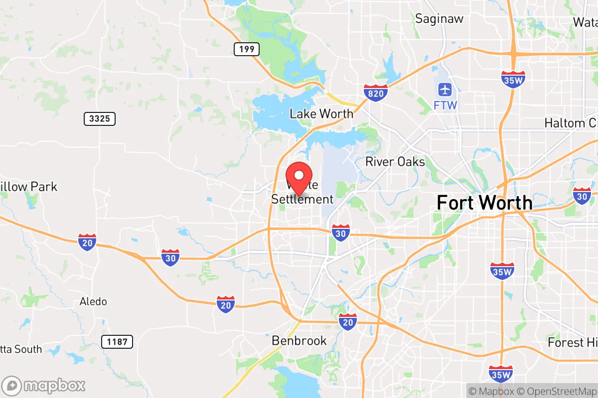
Strategic Assessment of White Settlement, TX
Multiple tactical vulnerabilities. Population density, target proximity, or disaster risk are likely compounding. A retreat property and exit planning is required.
What does the Strategic Assessment tell us?
Our Strategic Assessment grades tactical survivability of an area. Major population centers, military targets, fallout zones, natural disasters, and border exposure all drive risk — lower exposure means a more defensible position in a crisis.
This is heavily inspired by Joel Skousen's Strategic Relocation book. Highly recommended you checkout the book ($)What does this tell us?
Our Strategic Assessment grades tactical survivability of an area. Major population centers, military targets, fallout zones, natural disasters, and border exposure all drive risk — lower exposure means a more defensible position in a crisis.
This is heavily inspired by Joel Skousen's Strategic Relocation book. Highly recommended you checkout the book ($)Strategic Pillars

Key Distances
Regional Safe Places
Below is our recommended "safe zones" in Texas and the surrounding area based on our strategic heuristics. For most people, it's unrealistic to live in a “safe zone” full-time due to work, family or other personal reasons. They tend to be more rural. However, many of these areas are perfect for second homes and retreat properties that double as a vacation home or even a short-term rental.


Important Note: For informational purposes only. This does not mean nothing bad ever happens in the green zones. Please use common sense. This is based on public data and modeled with AI. We tried to take a conservative approach but mistakes happen. We update this regularly as new information becomes available.
Solar Generator Recommendations
Backup power matters more here than in safer locations. We've picked three solar generators across budgets and capacity tiers — start with the budget unit if you only need a few essentials, or step up if you want to run a fridge and HVAC for days at a time.

Jackery Portable Power Station Explorer 300
Budget OptionPower on the Go: Weighing only 11 lbs, it's convenient to set up and store with book-sized foldable solar panels

BLUETTI Portable Power Station AC180
Designed for both indoor and outdoor scenarios, AC180 is highly capable as it has a robost capacity and continuous output power.

EF ECOFLOW DELTA Pro Ultra Power Station
Upgraded PickEcoFlow DELTA Pro Ultra is a whole-home energy system designed to grow with your family. Integrated with the Smart Home Panel 2, it scales to meet your evolving energy needs — keeping your home powered, intelligent, and secure through every stage of life.
We earn a commission, at no additional cost to you.
Strategic Assessment Analysis
White Settlement, Texas, offers a surprisingly resilient strategic position for those prioritizing preparedness and self-sufficiency, provided you understand its specific trade-offs. Located just west of Fort Worth, this small city of roughly 18,000 residents sits at a critical inflection point: close enough to leverage the resources of the Dallas-Fort Worth metroplex, yet far enough to avoid the worst of urban collapse scenarios. Its key advantage is its position on the western edge of the Metroplex, placing it on the less-dense side of the urban sprawl, with open ranchland and the Brazos River basin within a 30-minute drive. For a relocator with a prepper mindset, White Settlement is a viable "bug-in" location with a credible "bug-out" route, but only if you account for the specific risks baked into its geography.
Geographic position and natural advantages for long-term survival
White Settlement's location on the western fringe of Tarrant County gives it a distinct edge over suburbs closer to Dallas. The city sits on the edge of the Cross Timbers ecoregion, a transitional zone between the blackland prairies to the east and the rolling plains to the west. This means better natural water drainage, less floodplain risk than areas near the Trinity River, and soil that supports both native forage and small-scale gardening. The area's elevation—roughly 650 to 700 feet above sea level—provides modest terrain advantages for line-of-sight and drainage, though nothing dramatic. Critically, the prevailing winds in North Texas blow from the south and southwest, meaning that fallout from a hypothetical event at the nuclear plants east of Dallas (Comanche Peak, 70 miles southwest, is actually upwind) would generally push away from White Settlement. The city's position also places it within a 20-minute drive of the expansive Lake Worth and Eagle Mountain Lake, both of which offer secondary water sources and fishing potential in a grid-down scenario. The nearby Fort Worth Nature Center & Refuge, a 3,600-acre protected area, provides a buffer of undeveloped land to the north, reducing the density of potential refugee flow from the city core.
Risks, exposures, and proximity to fallout-relevant landmarks
No analysis is honest without confronting the downsides. White Settlement's primary vulnerability is its proximity to Naval Air Station Joint Reserve Base Fort Worth, located less than 5 miles east of the city center. This is a major military airfield housing F-35s, F-16s, and reserve transport aircraft. In a conflict scenario, this base becomes a high-value target for both kinetic and cyber attacks. The base's presence also means regular military air traffic, which some residents find reassuring but others view as a potential vector for unwanted attention. Additionally, the city sits within a 15-mile radius of multiple rail lines and interstate highways (I-30, I-820, and I-35W) that serve as primary evacuation and supply corridors. In a mass-casualty event or civil unrest scenario, these routes will clog rapidly, and White Settlement could see significant "filter-down" traffic from Fort Worth evacuees moving west. The city's own road network is limited: the main arteries are White Settlement Road and Cherry Lane, both two-lane in many sections, creating chokepoints. On the positive side, the city's small-town layout—mostly residential with a few commercial strips—means fewer high-density targets than downtown Fort Worth. The Village Creek wastewater treatment plant and the Lake Worth water treatment plant are both within 10 miles, making them potential points of failure or contamination in a prolonged event. For the prepper, the key takeaway is that White Settlement is not a remote redoubt; it's a suburban buffer zone that requires active monitoring of the military base and highway conditions.
Practical resilience for a relocator: food, water, energy, and defensibility
For a relocator serious about self-sufficiency, White Settlement offers a mixed bag. Water is the most critical concern. The city draws its municipal supply from Lake Worth and Eagle Mountain Lake, both surface reservoirs subject to drought and contamination. A well is not a given here—most residential lots are on city water, and drilling a private well in Tarrant County requires permits and can run $10,000–$20,000 depending on depth (typically 200–400 feet to reach the Trinity Aquifer). Rainwater catchment is legal and practical, given the area's average 34 inches of annual rainfall, but HOA restrictions in some subdivisions may limit barrel placement. Food production is feasible: the growing season runs from March to November, and the soil, while clay-heavy, can be amended for vegetable gardens. Local ordinances allow backyard chickens (hens only, no roosters) and even small livestock on lots of one acre or more, but many subdivisions have deed restrictions. The city's zoning is largely residential, with limited agricultural land within city limits—you'll need to look at the unincorporated areas west of the city, toward Azle or Springtown, for true homesteading potential. Energy resilience is improving: solar adoption is growing, and net metering is available through Oncor, the local utility. However, the grid in this part of Texas is part of the ERCOT system, which has proven vulnerable to winter storms (2021) and summer heat waves. A backup generator or solar-plus-battery system is strongly advised. Defensibility is a mixed picture. The city's layout is a typical suburban grid, with cul-de-sacs and single-entry neighborhoods that can be secured with relative ease. The police department is small (roughly 30 officers) and response times in the outer neighborhoods can stretch to 10–15 minutes. The city has a strong sense of community, with active neighborhood watch programs and a conservative-leaning local government that generally supports Second Amendment rights. Tarrant County is a "shall-issue" county for concealed carry, and open carry is legal for those 21 and older. For a relocator, the practical play is to secure a home on the western edge of the city, near the boundary with unincorporated Parker County, where lot sizes increase and density drops.
The overall strategic picture for White Settlement is one of calculated risk. It is not a remote survivalist compound, nor is it a high-risk urban core. It occupies a middle ground that rewards preparation and situational awareness. The city's proximity to a major military base and interstate corridors is a double-edged sword: it provides economic stability and access to resources, but it also creates a target profile and evacuation chokepoints. For the conservative-leaning relocator who values community, local governance, and the ability to defend their home, White Settlement offers a viable base of operations—provided you invest in water independence, energy backup, and a solid plan for monitoring the base and highway conditions. The best advice is to treat White Settlement as a "forward operating base" rather than a final redoubt: use it for daily life and community, but have a pre-planned bug-out route west into the Hill Country or the Llano Estacado if the situation deteriorates beyond local control. The area's resilience is real, but it demands active participation, not passive assumption.
* Values derived from national, state, county, city and local statistics and may differ in a specific area. Last updated: 2026-04-27T02:23:31.000Z
Narrative content on this page is AI-generated and may contain mistakes. Verify any details that matter before acting on them.
ReloMaps may earn a commission from affiliate links at no extra cost to you.