
Photo: Wikipedia
Strategic Assessment of Wilmington, NC
Multiple tactical vulnerabilities. Population density, target proximity, or disaster risk are likely compounding. A retreat property and exit planning is required.
What does the Strategic Assessment tell us?
Our Strategic Assessment grades tactical survivability of an area. Major population centers, military targets, fallout zones, natural disasters, and border exposure all drive risk — lower exposure means a more defensible position in a crisis.
This is heavily inspired by Joel Skousen's Strategic Relocation book. Highly recommended you checkout the book ($)What does this tell us?
Our Strategic Assessment grades tactical survivability of an area. Major population centers, military targets, fallout zones, natural disasters, and border exposure all drive risk — lower exposure means a more defensible position in a crisis.
This is heavily inspired by Joel Skousen's Strategic Relocation book. Highly recommended you checkout the book ($)Strategic Pillars

Key Distances
Regional Safe Places
Below is our recommended "safe zones" in North Carolina and the surrounding area based on our strategic heuristics. For most people, it's unrealistic to live in a “safe zone” full-time due to work, family or other personal reasons. They tend to be more rural. However, many of these areas are perfect for second homes and retreat properties that double as a vacation home or even a short-term rental.


Important Note: For informational purposes only. This does not mean nothing bad ever happens in the green zones. Please use common sense. This is based on public data and modeled with AI. We tried to take a conservative approach but mistakes happen. We update this regularly as new information becomes available.
Solar Generator Recommendations
Backup power matters more here than in safer locations. We've picked three solar generators across budgets and capacity tiers — start with the budget unit if you only need a few essentials, or step up if you want to run a fridge and HVAC for days at a time.

Jackery Portable Power Station Explorer 300
Budget OptionPower on the Go: Weighing only 11 lbs, it's convenient to set up and store with book-sized foldable solar panels

BLUETTI Portable Power Station AC180
Designed for both indoor and outdoor scenarios, AC180 is highly capable as it has a robost capacity and continuous output power.

EF ECOFLOW DELTA Pro Ultra Power Station
Upgraded PickEcoFlow DELTA Pro Ultra is a whole-home energy system designed to grow with your family. Integrated with the Smart Home Panel 2, it scales to meet your evolving energy needs — keeping your home powered, intelligent, and secure through every stage of life.
We earn a commission, at no additional cost to you.
Strategic Assessment Analysis
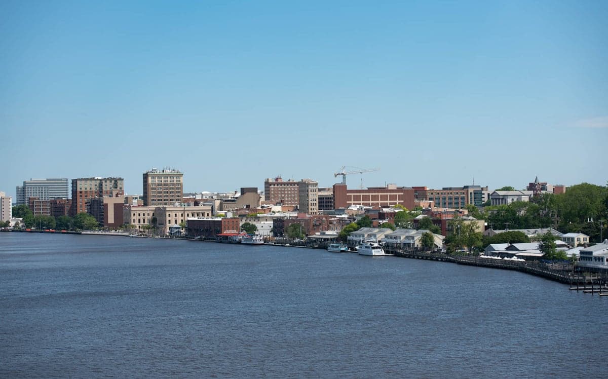
Wilmington, North Carolina, sits in a precarious strategic position that demands a clear-eyed assessment for anyone serious about long-term preparedness. Its coastal location offers genuine advantages in terms of temperate climate and access to maritime resources, but those same features place it squarely in the path of hurricane threats and within a dangerous proximity to major military and industrial targets. For the conservative prepper weighing relocation, Wilmington is a mixed bag—viable as a temporary staging area or a secondary retreat, but not the fortress-like sanctuary some might hope for.
Geographic position and natural advantages for long-term survival
Wilmington’s location on the Cape Fear River, roughly 15 miles inland from the Atlantic Ocean, provides a rare combination of freshwater access and coastal proximity without the immediate exposure of a beachfront property. The river itself is a navigable waterway that could serve as a transportation corridor or a source of fish and game in a grid-down scenario. The surrounding region—Brunswick, New Hanover, and Pender counties—offers a mix of pine forests, wetlands, and agricultural land that supports hunting, foraging, and small-scale farming. The climate is mild, with an average annual temperature around 63°F, meaning heating demands are low and growing seasons stretch from March to November. This reduces dependency on external energy for both warmth and food production, a critical factor when supply chains falter. The area also sits on the Atlantic Coastal Plain, with relatively flat terrain that simplifies travel on foot or by bicycle if fuel becomes scarce. For a relocator focused on self-sufficiency, the natural environment here is workable—not ideal, but far better than the arid West or the frozen Upper Midwest.
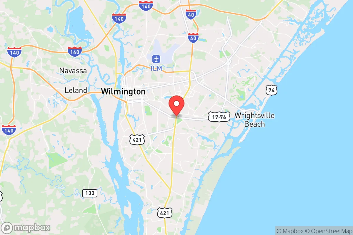
Risks, exposures, and proximity to fallout-relevant landmarks
The most glaring vulnerability is Wilmington’s proximity to Camp Lejeune Marine Corps Base, about 50 miles north, and Fort Bragg (now Fort Liberty), roughly 90 miles northwest. These are prime targets in any major conflict involving the United States, and a nuclear or conventional strike on either would send fallout, refugees, or both streaming toward the coast. Interstate 40, which runs directly from Fort Liberty through Wilmington, would become a chokepoint of desperate movement. Additionally, the Brunswick Nuclear Plant, located just 20 miles south of Wilmington in Southport, is a dual-reactor facility that could become a liability in a crisis—either as a target or as a source of radiological release if damaged by a hurricane or sabotage. The plant’s proximity to the coast and the Cape Fear River means any contamination would spread quickly through the region’s water systems. Hurricane risk is severe: Wilmington has been hit by major storms like Florence (2018) and Matthew (2016), both of which caused catastrophic flooding and weeks-long power outages. The city’s low elevation—much of it under 20 feet above sea level—makes storm surge and inland flooding a recurring threat. For the prepper, these are not abstract concerns; they are predictable, recurring events that will test any stockpile or bug-out plan.
Practical resilience for a relocator: food, water, energy, and defensibility
Water access is a strong point. The Cape Fear River is a reliable surface water source, but it requires filtration and treatment due to agricultural runoff, industrial discharge, and saltwater intrusion during droughts. The Castle Hayne aquifer, which supplies much of the region’s groundwater, is a better bet for well drilling, though permits and depth (often 200-400 feet) mean upfront cost and effort. Rainwater collection is viable given the area’s 57 inches of annual precipitation, but storage must account for hurricane contamination. Food production is feasible but not effortless: the sandy, acidic soil typical of the coastal plain requires amendment for serious gardening, and deer, turkey, and fish are abundant but not limitless. Local farmers’ markets and a handful of small-scale farms (like those in Pender County) offer some redundancy for barter networks. Energy resilience is middling. Duke Energy’s grid is prone to storm-related outages, and solar adoption is growing but not dominant. A propane generator or off-grid solar setup with battery storage is a wise investment here. Defensibility is the weak link. Wilmington’s population of roughly 120,000 (metro area over 300,000) means density is high enough to attract looters and desperate crowds during a collapse. The city’s layout—a mix of historic downtown, suburban sprawl, and riverfront industry—offers few natural chokepoints. The best defensive posture is to locate on the outskirts, ideally in rural Brunswick or Pender counties, where acreage and distance from major roads provide buffer. Even then, the two major bridges over the Cape Fear River (the Cape Fear Memorial Bridge and the Isabel Holmes Bridge) are critical infrastructure that could be blocked or destroyed, effectively cutting off the city’s western escape routes. A relocator should have a secondary bug-out location inland, toward Fayetteville or beyond, and a plan to move within 24 hours of a major event.
The overall strategic picture for Wilmington is one of calculated trade-offs. It offers a livable climate, abundant water, and a coastal resource base that can sustain a prepared individual or family through moderate disruptions. But its proximity to high-value military targets, a nuclear power plant, and a hurricane-prone coast means it is not a safe haven for long-term collapse scenarios. For the conservative prepper who values community and economic opportunity but is willing to maintain a low profile and a robust bug-out plan, Wilmington can work as a primary residence. For those seeking true isolation and defensibility—think the Idaho panhandle or the Ozarks—this is not the place. Treat it as a strategic outpost, not a fortress, and you’ll be ahead of 90% of the people who move here without a second thought.
* Values derived from national, state, county, city and local statistics and may differ in a specific area. Last updated: 2026-05-03T04:51:26.000Z
Narrative content on this page is AI-generated and may contain mistakes. Verify any details that matter before acting on them.
ReloMaps may earn a commission from affiliate links at no extra cost to you.