
Photo: Wikipedia
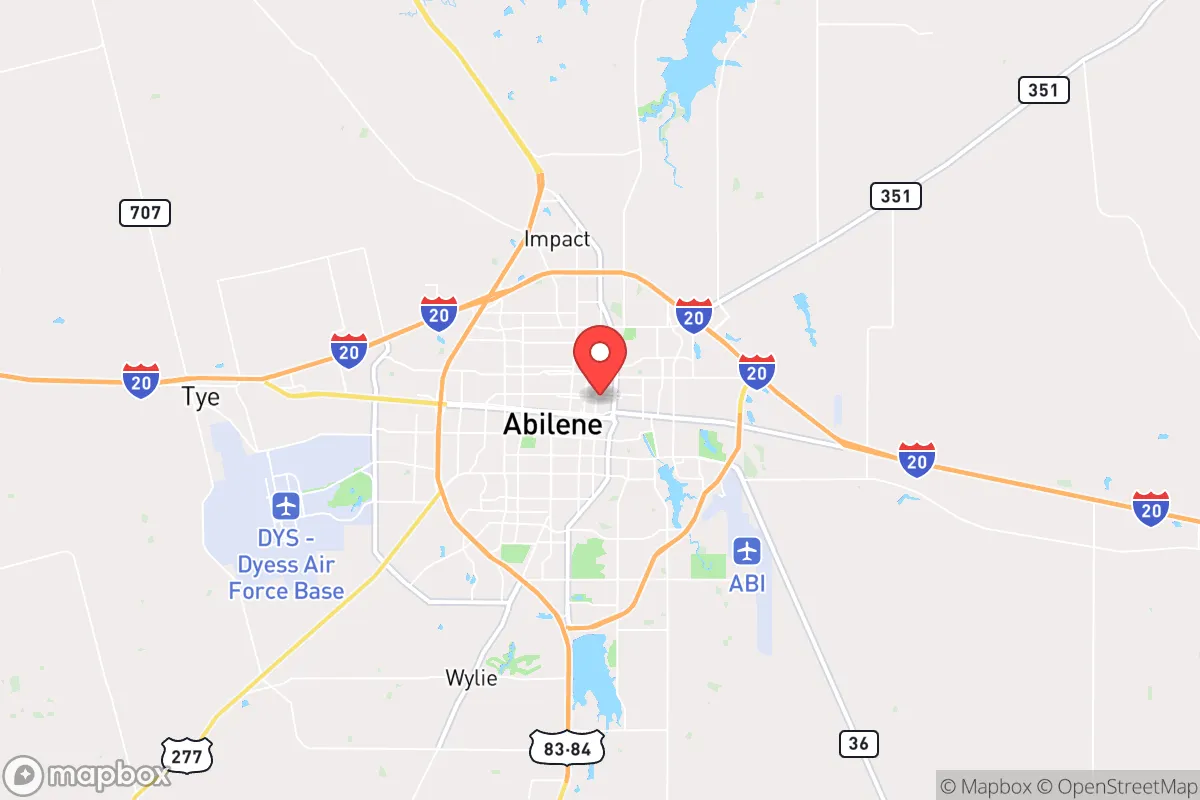
Strategic Assessment of Abilene, TX
Workable tactical position. Some exposure to population density or targets, but generally defensible in a crisis.
What does the Strategic Assessment tell us?
Our Strategic Assessment grades tactical survivability of an area. Major population centers, military targets, fallout zones, natural disasters, and border exposure all drive risk — lower exposure means a more defensible position in a crisis.
This is heavily inspired by Joel Skousen's Strategic Relocation book. Highly recommended you checkout the book ($)What does this tell us?
Our Strategic Assessment grades tactical survivability of an area. Major population centers, military targets, fallout zones, natural disasters, and border exposure all drive risk — lower exposure means a more defensible position in a crisis.
This is heavily inspired by Joel Skousen's Strategic Relocation book. Highly recommended you checkout the book ($)Strategic Pillars

Key Distances
Regional Safe Places
Below is our recommended "safe zones" in Texas and the surrounding area based on our strategic heuristics. For most people, it's unrealistic to live in a “safe zone” full-time due to work, family or other personal reasons. They tend to be more rural. However, many of these areas are perfect for second homes and retreat properties that double as a vacation home or even a short-term rental.


Important Note: For informational purposes only. This does not mean nothing bad ever happens in the green zones. Please use common sense. This is based on public data and modeled with AI. We tried to take a conservative approach but mistakes happen. We update this regularly as new information becomes available.
Solar Generator Recommendations
Backup power matters more here than in safer locations. We've picked three solar generators across budgets and capacity tiers — start with the budget unit if you only need a few essentials, or step up if you want to run a fridge and HVAC for days at a time.

Jackery Portable Power Station Explorer 300
Budget OptionPower on the Go: Weighing only 11 lbs, it's convenient to set up and store with book-sized foldable solar panels

BLUETTI Portable Power Station AC180
Designed for both indoor and outdoor scenarios, AC180 is highly capable as it has a robost capacity and continuous output power.

EF ECOFLOW DELTA Pro Ultra Power Station
Upgraded PickEcoFlow DELTA Pro Ultra is a whole-home energy system designed to grow with your family. Integrated with the Smart Home Panel 2, it scales to meet your evolving energy needs — keeping your home powered, intelligent, and secure through every stage of life.
We earn a commission, at no additional cost to you.
Strategic Assessment Analysis
Abilene, Texas, sits in a strategic sweet spot that makes it a serious contender for anyone thinking long-term about resilience and self-reliance. Roughly 150 miles west of the Dallas-Fort Worth metroplex and 200 miles northwest of Austin, it’s far enough from the major population centers to avoid the worst of any urban collapse, yet close enough to access their resources if things stabilize. The city’s population hovers around 125,000, with Taylor County adding another 15,000 or so—small enough to avoid the chaos of a megacity, but large enough to maintain a functional economy and infrastructure. For a conservative-leaning relocator worried about civic unrest, mass casualty events, or natural disasters, Abilene offers a blend of geographic isolation, resource availability, and community cohesion that’s hard to beat in the modern era.
Geographic position and natural advantages for long-term security
Abilene’s location in the rolling plains of West Texas gives it a few hard-to-ignore natural advantages. The terrain is mostly flat to gently hilly, with sparse tree cover—not ideal for concealment, but excellent for visibility and defense if you’re securing a homestead. The area sits on the Edwards Plateau, which means the soil is decent for small-scale agriculture, and the climate is semi-arid, with hot summers and mild winters. Annual rainfall averages about 24 inches, enough to support dryland farming of grains, hay, and some vegetables, but not so much that you’re dealing with constant flooding or mold issues. The lack of major waterways means no risk of catastrophic river flooding, though flash floods in low-lying areas are a minor concern during heavy storms. The nearest nuclear power plant is the Comanche Peak facility near Glen Rose, about 120 miles east—well outside the typical 50-mile emergency planning zone, so fallout from a plant incident is unlikely to be a direct threat. The same distance applies to the Pantex nuclear weapons assembly plant near Amarillo, roughly 150 miles northwest. For a prepper, this is a solid buffer: you’re not in the blast radius of any strategic target, but you’re close enough to monitor events and adjust.
Risks, exposures, and proximity to fallout-relevant landmarks
No location is perfect, and Abilene has its share of risks that a strategic relocator needs to weigh. The biggest concern is the city’s proximity to Dyess Air Force Base, which sits just west of town. Dyess is home to the 7th Bomb Wing, operating B-1B Lancer bombers, and the 317th Airlift Wing with C-130J transports. In a major conflict or escalation, that base becomes a high-value target. A conventional strike or even a small tactical nuke aimed at Dyess would put Abilene in the danger zone—though the base is about 10 miles from downtown, so the immediate blast effects would be limited to the western outskirts. Fallout patterns depend on wind, but prevailing winds in West Texas blow from the south and southwest, meaning radioactive debris would likely drift northeast, away from the city center. Still, anyone living within 20 miles of the base should have a fallout shelter plan. Beyond military risks, Abilene sits in Tornado Alley, with an average of 5-10 tornado warnings per year. The flat terrain means storms can develop quickly, and the city has seen EF-2 and EF-3 tornadoes in the past, like the 2021 event that damaged parts of the southern edge. Wildfire risk is moderate, especially in dry years, but the sparse vegetation limits fuel loads compared to forested areas. The biggest natural hazard is drought—Abilene has experienced severe multi-year droughts, most recently in 2011-2014, which stressed water supplies and forced conservation measures. For a prepper, that means water storage and well access are non-negotiable.
Practical resilience for a relocator: food, water, energy, and defensibility
When you break down the practicalities of living in Abilene from a survivalist perspective, the picture is mixed but workable. Water is the single biggest concern. The city draws from Lake Fort Phantom Hill and O.H. Ivie Reservoir, both of which have seen levels drop during droughts. The municipal supply is generally reliable, but if you’re off-grid or want redundancy, the Ogallala Aquifer is accessible in the region, though it’s deeper here than in the Panhandle—wells typically run 200-400 feet. Rainwater catchment is viable given the 24-inch annual rainfall, but you’ll need significant storage to get through dry spells. Food production is feasible if you’re willing to work the land. The growing season runs about 220 days, from March to November, and you can raise cattle, goats, chickens, and crops like corn, wheat, and sorghum. The local farmers’ markets and co-ops are small but active, and the surrounding rural counties have a strong agricultural base. Energy is a bright spot. Texas’s ERCOT grid is notoriously fragile during winter storms—the 2021 freeze knocked out power for days across the state—but Abilene has a higher-than-average rate of solar adoption, and many rural properties already run on propane or diesel generators. The wind resource is excellent, with average speeds of 12-15 mph, making small-scale wind turbines a realistic option. Defensibility is where Abilene shines. The city’s layout is compact, with a central downtown and residential neighborhoods radiating outward. The surrounding countryside is open ranchland, which means you can see threats coming from miles away. The local gun culture is strong—Taylor County has one of the highest per-capita firearm ownership rates in Texas—and the sheriff’s office is pro-Second Amendment. For a relocator, this means you’re not going to be the only armed household in a crisis. The community is tight-knit, with a strong church presence and a “neighbor helps neighbor” ethos that’s increasingly rare in urban areas. That social fabric is a resilience asset in itself.
Overall, Abilene presents a solid strategic option for someone looking to ride out the coming storms—whether they’re economic, political, or environmental. The downsides are real: water scarcity, tornado risk, and the military target next door. But the upsides—distance from major cities, arable land, energy independence potential, and a community that doesn’t panic easily—make it a place worth serious consideration. If you’re the type who wants to be prepared without living in a bunker, Abilene offers a middle path: enough isolation to avoid the worst of a collapse, but enough infrastructure to maintain a decent quality of life while you build your own resilience. Just make sure you’ve got a well, a generator, and a plan for the day Dyess lights up the sky. That’s not pessimism—that’s Texas pragmatism.
* Values derived from national, state, county, city and local statistics and may differ in a specific area. Last updated: 2026-04-15T13:58:58.000Z
Narrative content on this page is AI-generated and may contain mistakes. Verify any details that matter before acting on them.
ReloMaps may earn a commission from affiliate links at no extra cost to you.