Photo: Evan McNamara via Unsplash
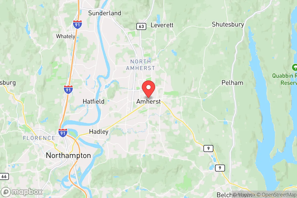
Strategic Assessment of Amherst Town, MA
Multiple tactical vulnerabilities. Population density, target proximity, or disaster risk are likely compounding. A retreat property and exit planning is required.
What does the Strategic Assessment tell us?
Our Strategic Assessment grades tactical survivability of an area. Major population centers, military targets, fallout zones, natural disasters, and border exposure all drive risk — lower exposure means a more defensible position in a crisis.
This is heavily inspired by Joel Skousen's Strategic Relocation book. Highly recommended you checkout the book ($)What does this tell us?
Our Strategic Assessment grades tactical survivability of an area. Major population centers, military targets, fallout zones, natural disasters, and border exposure all drive risk — lower exposure means a more defensible position in a crisis.
This is heavily inspired by Joel Skousen's Strategic Relocation book. Highly recommended you checkout the book ($)Strategic Pillars

Key Distances
Regional Safe Places
Below is our recommended "safe zones" in Massachusetts and the surrounding area based on our strategic heuristics. For most people, it's unrealistic to live in a “safe zone” full-time due to work, family or other personal reasons. They tend to be more rural. However, many of these areas are perfect for second homes and retreat properties that double as a vacation home or even a short-term rental.


Important Note: For informational purposes only. This does not mean nothing bad ever happens in the green zones. Please use common sense. This is based on public data and modeled with AI. We tried to take a conservative approach but mistakes happen. We update this regularly as new information becomes available.
Solar Generator Recommendations
Backup power matters more here than in safer locations. We've picked three solar generators across budgets and capacity tiers — start with the budget unit if you only need a few essentials, or step up if you want to run a fridge and HVAC for days at a time.

Jackery Portable Power Station Explorer 300
Budget OptionPower on the Go: Weighing only 11 lbs, it's convenient to set up and store with book-sized foldable solar panels

BLUETTI Portable Power Station AC180
Designed for both indoor and outdoor scenarios, AC180 is highly capable as it has a robost capacity and continuous output power.

EF ECOFLOW DELTA Pro Ultra Power Station
Upgraded PickEcoFlow DELTA Pro Ultra is a whole-home energy system designed to grow with your family. Integrated with the Smart Home Panel 2, it scales to meet your evolving energy needs — keeping your home powered, intelligent, and secure through every stage of life.
We earn a commission, at no additional cost to you.
Strategic Assessment Analysis
Amherst Town, Massachusetts, presents a complex strategic picture for the conservative-leaning relocator focused on resilience and preparedness. While its location in the Pioneer Valley offers some natural advantages—ample water, fertile soil, and a moderate climate—it sits squarely within a region dominated by progressive politics, dense academic institutions, and proximity to major population centers that could become focal points during civil unrest or a major disaster. The town’s resilience is a double-edged sword: its physical geography provides some buffer, but its social and political geography introduces significant vulnerabilities for those seeking long-term security and self-sufficiency.
Geographic position and natural advantages for long-term survival
Amherst’s position in the Connecticut River Valley is its strongest natural asset. The valley is one of the most agriculturally productive regions in New England, with deep, well-drained soils and a reliable growing season of roughly 150 days. For a prepper focused on food security, this means the potential for serious subsistence farming, orchards, and livestock—far more viable than rocky, forested terrain just 20 miles east. The town itself sits at the confluence of several minor streams that feed the Fort River and Mill River, both tributaries of the Connecticut River. Surface water is abundant, and groundwater tables are generally high, making well drilling a realistic option for off-grid water supply. The surrounding hills—the Holyoke Range to the south and the Pelham Hills to the east—offer natural defensible positions and limited road access, which could slow movement of large groups during a crisis. However, the valley floor is open and exposed, meaning a retreat to higher ground would be necessary for any serious security posture. The region’s moderate climate avoids the extreme cold of northern New England, reducing heating fuel demands, but also means milder winters that don’t reliably kill off pests or disease vectors. Overall, the natural resource base is solid, but the terrain is not ideal for a hard defensive stand without significant preparation.
Risks, exposures, and proximity to fallout-relevant landmarks
This is where Amherst’s strategic picture darkens considerably. The town is less than 25 miles from the Springfield-Hartford metropolitan corridor, a dense urban area with over 1.5 million people. During a major economic collapse, grid failure, or civil unrest, that population would likely flow west into the less-dense Pioneer Valley, seeking food and water. Amherst itself is home to the University of Massachusetts Amherst (UMass), the largest public university in New England, with over 30,000 students and staff. In a crisis, a campus of that size becomes a liability—a concentrated population with limited local food storage, high dependence on external supply chains, and a demographic profile that tends toward progressive activism. The presence of multiple colleges (Amherst College, Hampshire College) amplifies this risk. Furthermore, the town is within 50 miles of the Vermont Yankee nuclear site (decommissioned but still storing spent fuel) and roughly 60 miles from the Seabrook Station nuclear plant in New Hampshire. While not immediate fallout zones, prevailing winds from the west and southwest could carry contamination into the valley in a worst-case scenario. The region also sits near the Quabbin Reservoir, a critical water source for Boston, which could become a target for sabotage or a flashpoint for resource conflict during a prolonged emergency. For the conservative prepper, Amherst’s proximity to these population and infrastructure risks outweighs its natural advantages unless a very specific, well-fortified retreat is established in the surrounding hills.
Practical resilience for a relocator: food, water, energy, and defensibility
For a single individual or family willing to invest heavily in preparation, Amherst offers a mixed bag. Food production is viable—the growing season is long enough for corn, beans, squash, potatoes, and hardy greens, and local farmers’ markets and CSAs are abundant in normal times. But the town’s zoning and land-use regulations are restrictive; building a large greenhouse, keeping livestock like pigs or goats, or drilling a private well on a small lot may require permits and face neighbor opposition. Water is plentiful but not guaranteed off-grid. The municipal water system draws from the Quabbin and local wells, but a prolonged power outage would shut down pumps. A private well with a hand pump or solar-powered backup is essential, and that requires acreage outside the dense village center. Energy resilience is poor by default. The region is heavily dependent on the New England grid, which is vulnerable to winter storms, cyberattacks, and fuel supply disruptions. Solar potential is moderate—about 4.5 peak sun hours per day on average—but tree cover in the hills limits rooftop options. Wood heating is viable, with ample hardwood forests within a 10-mile radius, but cutting and seasoning enough wood for a winter requires time, equipment, and physical labor. Defensibility is the weakest link. The valley floor is open, with multiple state highways (Routes 9, 116, 63) funneling traffic through town. A determined group could easily bypass any roadblocks via the many secondary roads and trails. The hills offer better positions, but they are not remote—Amherst is a college town with a dense road network. For a relocator seeking a true bug-out location or a homestead that can be held against a crowd, Amherst is not ideal. It works better as a semi-rural base for someone who plans to integrate into the local community and rely on mutual aid networks, rather than go full isolationist.
The overall strategic picture for Amherst is one of moderate natural resources undermined by high population density, political friction, and infrastructure fragility. For the conservative prepper, the town’s agricultural potential and water access are real assets, but they come with the constant risk of being overwhelmed by urban refugees or caught in the crossfire of civil unrest emanating from the Springfield-Hartford corridor or the UMass campus. A relocator could make it work with a well-chosen property on the eastern slopes of the Holyoke Range, a deep well, solar backup, and a low profile. But for anyone prioritizing true strategic depth—distance from population centers, defensible terrain, and low regulatory burden—Amherst is a compromise location at best. It is not a survivalist’s paradise, but it could serve as a staging ground for those willing to put in the work and accept the risks of living in a blue-state college town during uncertain times.
* Values derived from national, state, county, city and local statistics and may differ in a specific area. Last updated: 2026-04-19T07:41:37.000Z
Narrative content on this page is AI-generated and may contain mistakes. Verify any details that matter before acting on them.
ReloMaps may earn a commission from affiliate links at no extra cost to you.