Photo: Wikipedia
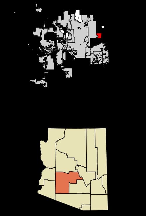
Strategic Assessment of Fountain Hills, AZ
Multiple tactical vulnerabilities. Population density, target proximity, or disaster risk are likely compounding. A retreat property and exit planning is required.
What does the Strategic Assessment tell us?
Our Strategic Assessment grades tactical survivability of an area. Major population centers, military targets, fallout zones, natural disasters, and border exposure all drive risk — lower exposure means a more defensible position in a crisis.
This is heavily inspired by Joel Skousen's Strategic Relocation book. Highly recommended you checkout the book ($)What does this tell us?
Our Strategic Assessment grades tactical survivability of an area. Major population centers, military targets, fallout zones, natural disasters, and border exposure all drive risk — lower exposure means a more defensible position in a crisis.
This is heavily inspired by Joel Skousen's Strategic Relocation book. Highly recommended you checkout the book ($)Strategic Pillars

Key Distances
Regional Safe Places
Below is our recommended "safe zones" in Arizona and the surrounding area based on our strategic heuristics. For most people, it's unrealistic to live in a “safe zone” full-time due to work, family or other personal reasons. They tend to be more rural. However, many of these areas are perfect for second homes and retreat properties that double as a vacation home or even a short-term rental.
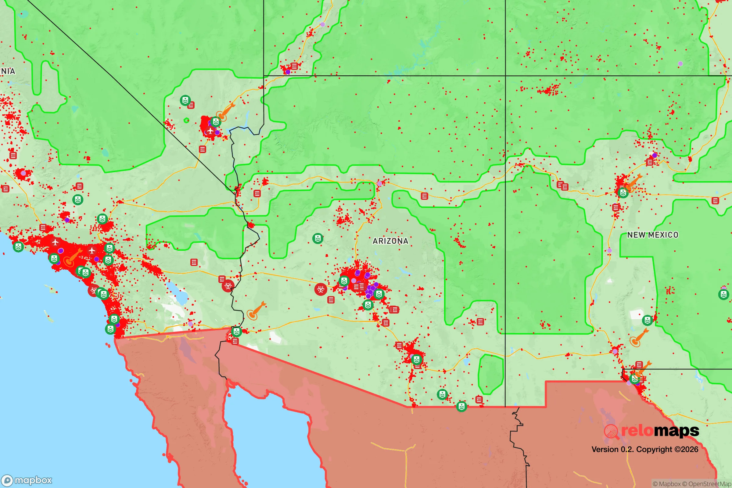
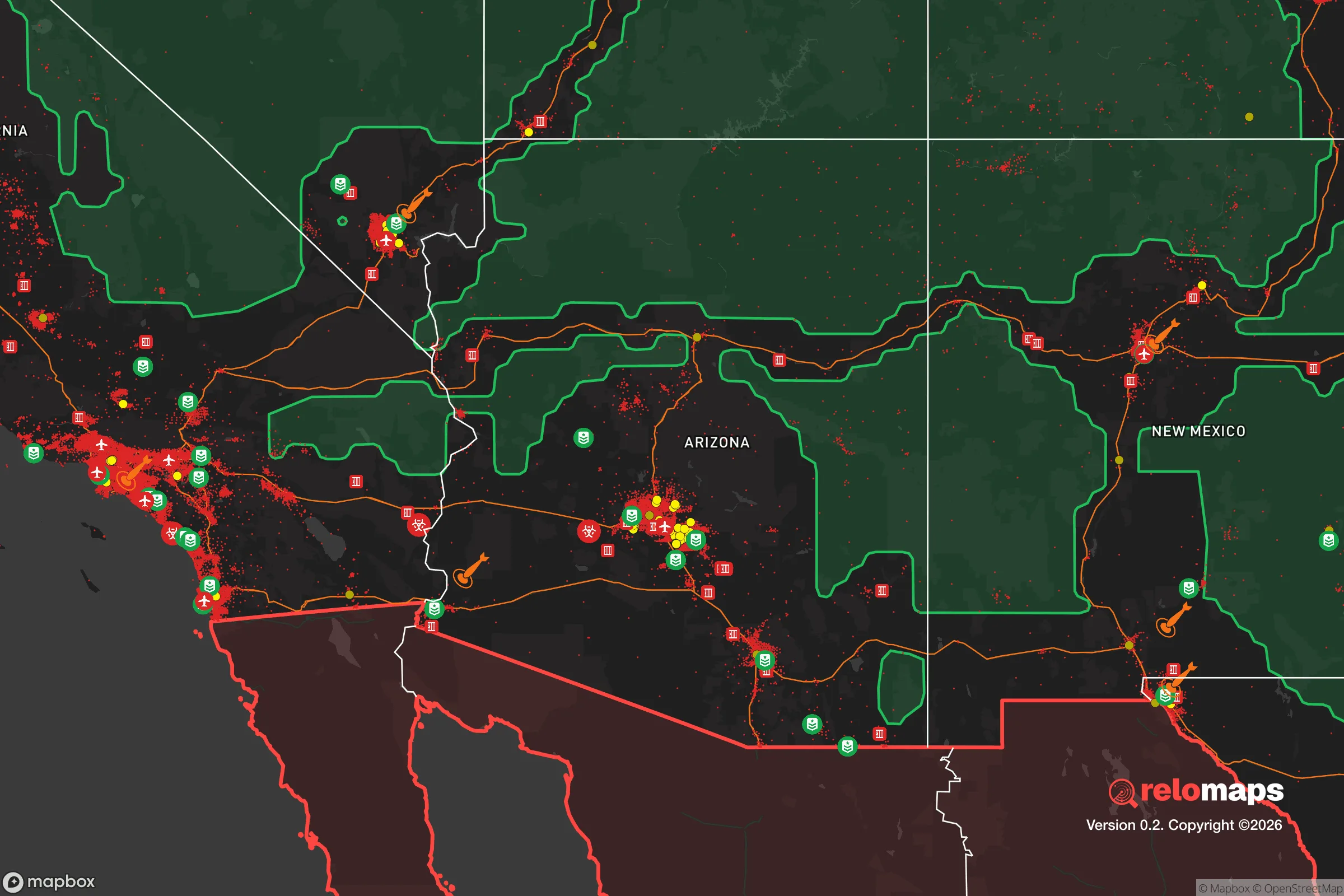
Important Note: For informational purposes only. This does not mean nothing bad ever happens in the green zones. Please use common sense. This is based on public data and modeled with AI. We tried to take a conservative approach but mistakes happen. We update this regularly as new information becomes available.
Solar Generator Recommendations
Backup power matters more here than in safer locations. We've picked three solar generators across budgets and capacity tiers — start with the budget unit if you only need a few essentials, or step up if you want to run a fridge and HVAC for days at a time.

Jackery Portable Power Station Explorer 300
Budget OptionPower on the Go: Weighing only 11 lbs, it's convenient to set up and store with book-sized foldable solar panels

BLUETTI Portable Power Station AC180
Designed for both indoor and outdoor scenarios, AC180 is highly capable as it has a robost capacity and continuous output power.

EF ECOFLOW DELTA Pro Ultra Power Station
Upgraded PickEcoFlow DELTA Pro Ultra is a whole-home energy system designed to grow with your family. Integrated with the Smart Home Panel 2, it scales to meet your evolving energy needs — keeping your home powered, intelligent, and secure through every stage of life.
We earn a commission, at no additional cost to you.
Strategic Assessment Analysis
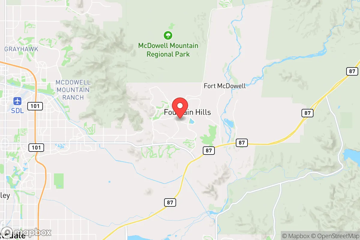
Fountain Hills, Arizona, sits roughly 30 miles northeast of downtown Phoenix, and its strategic value for a prepper or survivalist-minded relocator comes down to a single, sharp trade-off: you get genuine geographic defensibility and a semi-arid fortress environment, but you remain within the blast-shadow of a major metropolitan target. The town itself—built around a 560-foot fountain that was once the world’s tallest—is a master-planned community of about 26,000 people, perched on the western edge of the McDowell Mountain range. Its elevation (roughly 1,500 feet) and position on the Verde River watershed give it a resilience profile that’s rare in the Valley of the Sun, but the proximity to Phoenix’s population density, military installations, and critical infrastructure means you cannot treat it as a bug-out paradise. This analysis treats Fountain Hills as a potential base for a prepared individual or family who wants to be close enough to urban resources to sustain a normal life, but far enough out to have a fighting chance when things go sideways.
Geographic position and natural advantages for long-term survival
Fountain Hills occupies a natural bowl formed by the McDowell Mountains to the south and east, the Verde River corridor to the north, and the Salt River Pima-Maricopa Indian Community to the west. This topography provides a built-in defensive perimeter: the McDowell Sonoran Preserve, a 30,000-acre protected area, creates a rugged, trackless buffer on the eastern flank that would be extremely difficult for any large-scale movement of people or vehicles to cross. The Verde River, while not a raging torrent, is a perennial water source—one of the few in central Arizona that flows year-round—and its riparian corridor offers both a water supply and a natural barrier to the north. The town’s elevation also gives it a slight temperature advantage over Phoenix proper; summer highs are typically 5–7°F cooler, which reduces heat-stress risk during a prolonged grid-down event. For a relocator thinking in terms of decades, not just the next election cycle, the presence of the McDowell Mountains means you have a high-ground observation point, a potential retreat zone, and a source of firewood and game (mule deer, javelina, quail) that most suburban communities lack entirely.
Risks, exposures, and proximity to fallout-relevant landmarks
The single biggest vulnerability for Fountain Hills is its proximity to Luke Air Force Base (about 40 miles west) and Phoenix Sky Harbor International Airport (about 30 miles southwest). In a major conflict scenario—whether a conventional war or a terrorist strike—these are high-value targets. Luke is the largest fighter wing base in the world, home to F-35s and F-16s, and Sky Harbor is a major civilian air hub. A kinetic or nuclear strike on either would put Fountain Hills within the fallout plume zone depending on wind direction, and the prevailing winds in the Phoenix area are from the west and southwest, meaning a strike on Luke or downtown Phoenix would push contamination directly toward the northeast—right into Fountain Hills. The town is also within 15 miles of the Salt River Project’s major water infrastructure (the Granite Reef Diversion Dam and the CAP canal system), which could be a secondary target for anyone trying to cripple the region’s water supply. On the civil unrest front, Fountain Hills is a relatively wealthy, predominantly white, conservative-leaning community (Maricopa County voted +2 R in 2024, but the town itself is more solidly red), which could make it a target for roving groups during a breakdown of order. The single road in and out—Shea Boulevard (AZ 87)—is a choke point that would become impassable in a mass evacuation scenario. There is no secondary paved route that doesn’t require going through Scottsdale or the reservation, both of which would be equally clogged.
Practical resilience for a relocator: food, water, energy, and defensibility
Water is the first and hardest constraint. Fountain Hills gets its municipal water from the Central Arizona Project (CAP) canal and groundwater wells. In a prolonged grid-down event, the CAP pumps would stop, and the wells would require backup power. A prepper moving here needs to assume they are on their own for water after 72 hours. The Verde River is accessible via the Tonto National Forest to the north, but it’s a 5–10 mile hike from most residential areas, and you’d be competing with every other prepared person in the region. Rainwater harvesting is legal in Arizona, but the average annual rainfall is only 9 inches—you’d need a massive cistern system to make it work. Food resilience is better: the town has a farmers’ market and several small-scale growers, but the real advantage is the ability to store supplies. Homes here typically have garages and some have basements (rare in Arizona), and the dry climate means long-term food storage is feasible without the mold and humidity issues of the Southeast. Energy is a mixed bag: solar potential is excellent (300+ sunny days per year), but the town’s HOA covenants can be restrictive on panel placement and battery systems. Check the CC&Rs before buying. Defensibility is the strongest card. The town’s layout—winding roads, cul-de-sacs, and a single primary artery—makes it naturally defensible against vehicular threats. The McDowell Mountains provide a backstop, and the open desert to the north and west gives clear lines of sight. A prepared household with a good perimeter, stored water, and a community network could hold out for weeks. The downside is that the same geography that makes it defensible also makes it a trap if you need to leave in a hurry.
The overall strategic picture for Fountain Hills is that of a high-potential but high-risk location for a survivalist-minded relocator. It offers genuine natural defenses, a cooler climate, and proximity to a major water source, all within a community that is politically and culturally aligned with conservative values. But the proximity to Phoenix and its military and infrastructure targets means you are betting that the worst-case scenario doesn’t involve a strike on Luke or a nuclear detonation in the Valley. If you are looking for a place to ride out a slow-motion collapse—economic instability, civil unrest, supply chain disruptions—Fountain Hills is a strong candidate. If you are preparing for a full-scale war or a WMD event, you need to be another 50–100 miles farther out, into the high country around Payson or Show Low. For the single individual or family who wants to be prepared but still hold a job in Phoenix, this is one of the better options in the state. Just don’t kid yourself about the evacuation route, and make sure your water plan is rock solid before you sign the deed.
* Values derived from national, state, county, city and local statistics and may differ in a specific area. Last updated: 2026-04-19T08:12:20.000Z
Narrative content on this page is AI-generated and may contain mistakes. Verify any details that matter before acting on them.
ReloMaps may earn a commission from affiliate links at no extra cost to you.