Photo: Wikipedia
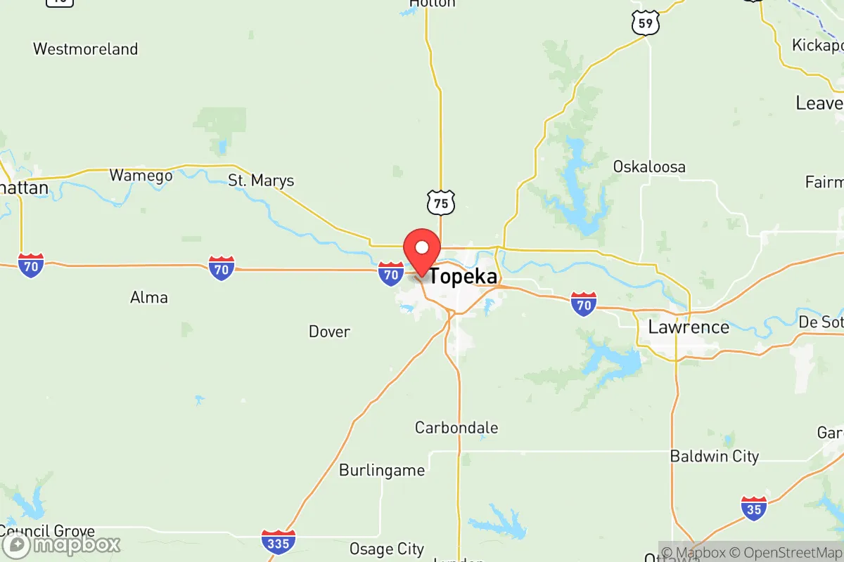
Strategic Assessment of Shawnee County
Workable tactical position. Some exposure to population density or targets, but generally defensible in a crisis.
What does the Strategic Assessment tell us?
Our Strategic Assessment grades tactical survivability of an area. Major population centers, military targets, fallout zones, natural disasters, and border exposure all drive risk — lower exposure means a more defensible position in a crisis.
This is heavily inspired by Joel Skousen's Strategic Relocation book. Highly recommended you checkout the book ($)What does this tell us?
Our Strategic Assessment grades tactical survivability of an area. Major population centers, military targets, fallout zones, natural disasters, and border exposure all drive risk — lower exposure means a more defensible position in a crisis.
This is heavily inspired by Joel Skousen's Strategic Relocation book. Highly recommended you checkout the book ($)Strategic Pillars

Key Distances
Strategic Assessment Analysis
Shawnee County, anchored by Topeka, offers a surprisingly resilient position for those prioritizing strategic relocation away from major population centers, though it is not without its own vulnerabilities. Its location along the I-70 corridor places it roughly 60 miles from the Kansas City metroplex—close enough for supply runs or medical access, but far enough to avoid the immediate blast radius or civil chaos of a major urban collapse. The county’s population of around 165,000 provides a buffer of anonymity and local resources without the suffocating density of a city like Overland Park or Wichita. For a conservative-leaning individual or family looking to weather civic unrest or national-scale disruptions, Shawnee County presents a mixed bag: solid agricultural and water assets, but real exposure to government and industrial targets.
Geographic position and natural advantages for long-term security
Shawnee County sits in the rolling Flint Hills region, which offers a distinct natural advantage: the terrain is hilly and rocky, making large-scale mechanized agriculture difficult but providing excellent defensible positions and natural cover. The Kansas River cuts through the county’s northern half, providing a reliable surface water source that is less prone to contamination than shallow aquifers in flatter parts of the state. The county’s position in the eastern third of Kansas means it receives roughly 35 inches of rainfall annually—enough for dryland farming without the irrigation dependency of western Kansas. For a relocator, this means you can realistically establish a small homestead with a well, solar panels, and a garden without fighting desert conditions. The city of Topeka itself is surrounded by rural towns like Silver Lake, Rossville, and Dover, where land prices remain reasonable (often under $5,000 per acre) and zoning is minimal. The county’s proximity to the Kansas River also offers a potential barge or boat evacuation route east toward the Missouri River if roads become impassable.
Risks, exposures, and proximity to fallout-relevant landmarks
Here’s where the analysis gets sobering. Shawnee County is not a blank slate—it hosts several high-value targets that would make it a secondary or tertiary priority in a major conflict or terrorist event. Forbes Field Air National Guard Base, located just south of Topeka, is a clear military target, housing the 190th Air Refueling Wing and KC-135 tankers. A conventional or nuclear strike on Forbes would produce significant fallout across the eastern half of the county, particularly downwind toward Auburn and Wakarusa. Additionally, the county contains the Topeka VA Medical Center and the Kansas State Capitol complex, both of which could become focal points for civil unrest or government-directed chaos. The BNSF Railway’s main line runs through Topeka, carrying hazardous materials including crude oil and anhydrous ammonia—a derailment or sabotage event could render large swaths of the city uninhabitable for days. For the prepper, the key takeaway is this: avoid living within 10 miles of Forbes Field, the rail yards, or the I-70/I-470 interchange. The rural townships north of the Kansas River—like Elmont and Indian Hills—offer better standoff distance from these risks while still being within a 20-minute drive of Topeka’s hospitals and hardware stores.
Practical resilience for a relocator: food, water, energy, and defensibility
On the practical side, Shawnee County scores well for self-sufficiency if you choose your location carefully. The county’s agricultural base is strong: Shawnee County ranks in the top 20% of Kansas counties for corn and soybean production, and there are dozens of small-scale livestock operations selling direct to consumers. The Topeka Farmers Market operates year-round, and local butchers like The Local Butcher in downtown Topeka can source whole animals. Water is the bigger concern—while the Kansas River is a reliable source, it also carries agricultural runoff and upstream industrial contaminants from Junction City and Manhattan. A deep well (200-400 feet) in the glacial drift aquifer is the gold standard, and many rural properties already have them. Electricity is grid-dependent, but the county has above-average solar insolation for the Midwest, and net metering policies from Evergy (the local utility) allow for grid-tied solar with battery backup. Defensibility varies by micro-location: the river bluffs north of Topeka offer natural chokepoints and long sightlines, while the flat farmland south of the river is harder to secure. For a family, the ideal setup is a 5-20 acre parcel in the northern half of the county, with a well, solar panels, a root cellar, and a clear line of sight to the only access road. The county’s gun laws are favorable—Kansas is a constitutional carry state, and Shawnee County has no additional firearm restrictions beyond state law.
The overall strategic picture for Shawnee County is one of cautious viability. It is not a remote survivalist paradise—you are still within 90 minutes of a major metropolitan area and within 30 minutes of a military airbase. But for the relocator who wants a balance of access to resources, a like-minded community, and the ability to ride out a crisis without being in the epicenter, it offers a realistic option. The key is to avoid the obvious danger zones—Forbes Field, the rail corridor, and the downtown government district—and instead focus on the rural northern and western townships where land is cheap, water is accessible, and neighbors are likely to share your worldview. If you can accept that you are not escaping civilization but rather positioning yourself at its resilient edge, Shawnee County deserves a serious look.
* Values derived from national, state, county, city and local statistics and may differ in a specific area. Last updated: 2026-06-01T12:00:29.000Z
Narrative content on this page is AI-generated and may contain mistakes. Verify any details that matter before acting on them.
ReloMaps may earn a commission from affiliate links at no extra cost to you.