
Photo: Wikipedia
Strategic Assessment of Kenilworth, IL
Multiple tactical vulnerabilities. Population density, target proximity, or disaster risk are likely compounding. A retreat property and exit planning is required.
What does the Strategic Assessment tell us?
Our Strategic Assessment grades tactical survivability of an area. Major population centers, military targets, fallout zones, natural disasters, and border exposure all drive risk — lower exposure means a more defensible position in a crisis.
This is heavily inspired by Joel Skousen's Strategic Relocation book. Highly recommended you checkout the book ($)What does this tell us?
Our Strategic Assessment grades tactical survivability of an area. Major population centers, military targets, fallout zones, natural disasters, and border exposure all drive risk — lower exposure means a more defensible position in a crisis.
This is heavily inspired by Joel Skousen's Strategic Relocation book. Highly recommended you checkout the book ($)Strategic Pillars

Key Distances
Regional Safe Places
Below is our recommended "safe zones" in Illinois and the surrounding area based on our strategic heuristics. For most people, it's unrealistic to live in a “safe zone” full-time due to work, family or other personal reasons. They tend to be more rural. However, many of these areas are perfect for second homes and retreat properties that double as a vacation home or even a short-term rental.
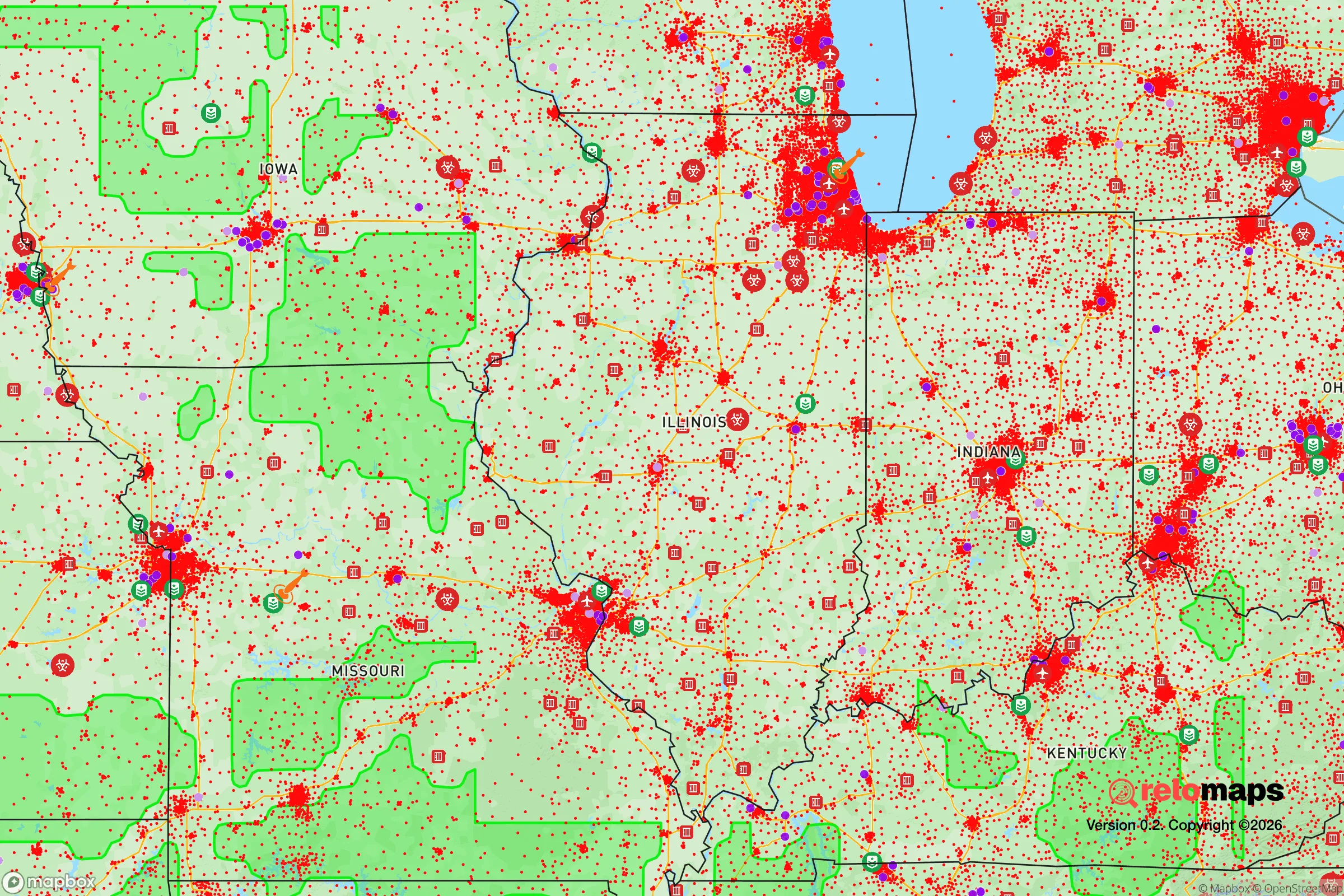
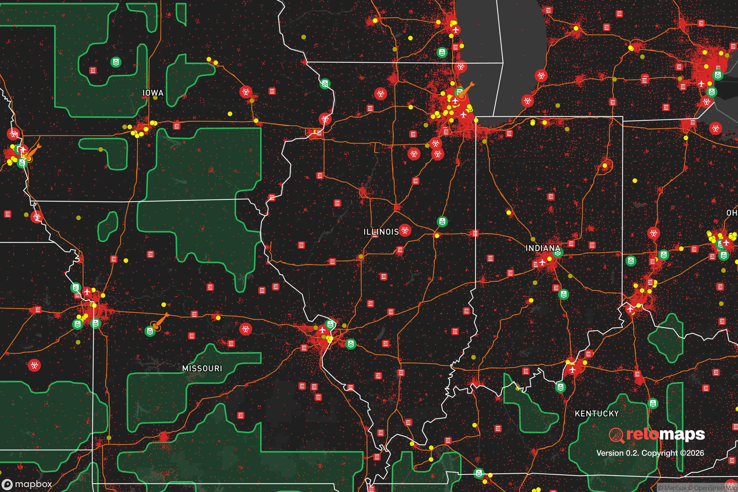
Important Note: For informational purposes only. This does not mean nothing bad ever happens in the green zones. Please use common sense. This is based on public data and modeled with AI. We tried to take a conservative approach but mistakes happen. We update this regularly as new information becomes available.
Solar Generator Recommendations
Backup power matters more here than in safer locations. We've picked three solar generators across budgets and capacity tiers — start with the budget unit if you only need a few essentials, or step up if you want to run a fridge and HVAC for days at a time.

Jackery Portable Power Station Explorer 300
Budget OptionPower on the Go: Weighing only 11 lbs, it's convenient to set up and store with book-sized foldable solar panels

BLUETTI Portable Power Station AC180
Designed for both indoor and outdoor scenarios, AC180 is highly capable as it has a robost capacity and continuous output power.

EF ECOFLOW DELTA Pro Ultra Power Station
Upgraded PickEcoFlow DELTA Pro Ultra is a whole-home energy system designed to grow with your family. Integrated with the Smart Home Panel 2, it scales to meet your evolving energy needs — keeping your home powered, intelligent, and secure through every stage of life.
We earn a commission, at no additional cost to you.
Strategic Assessment Analysis
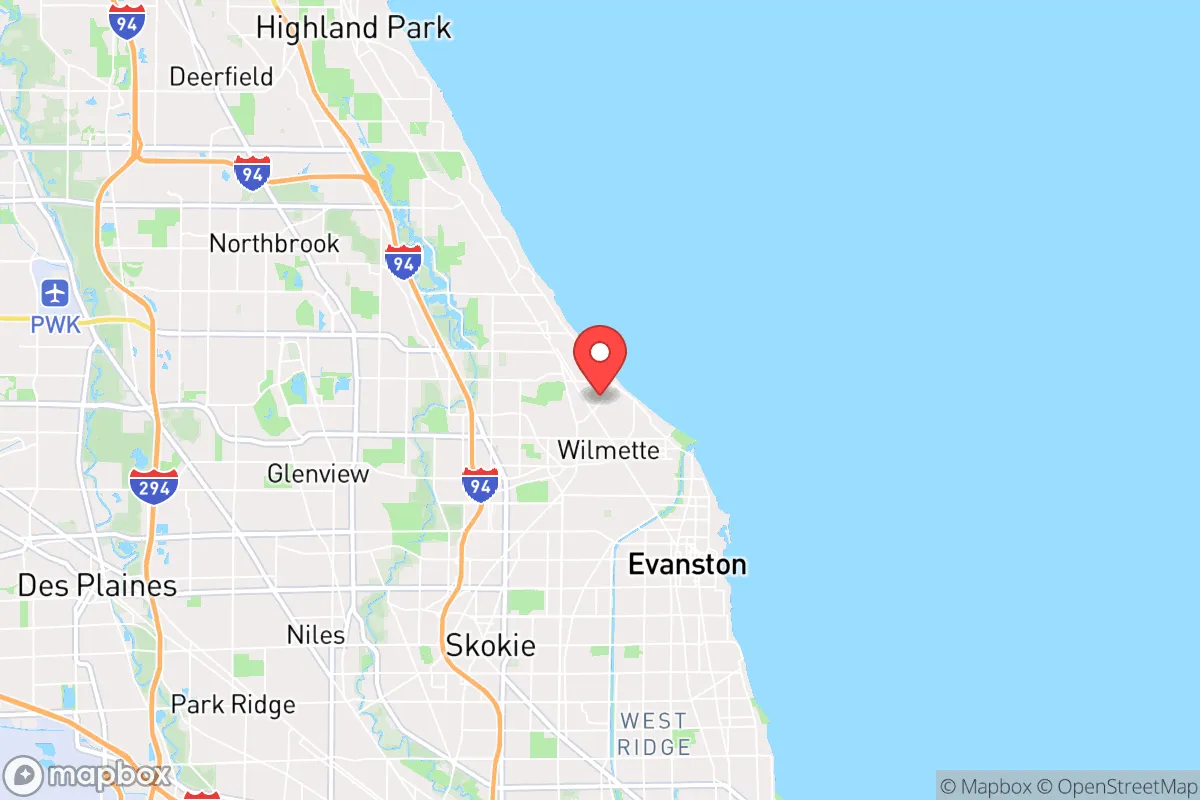
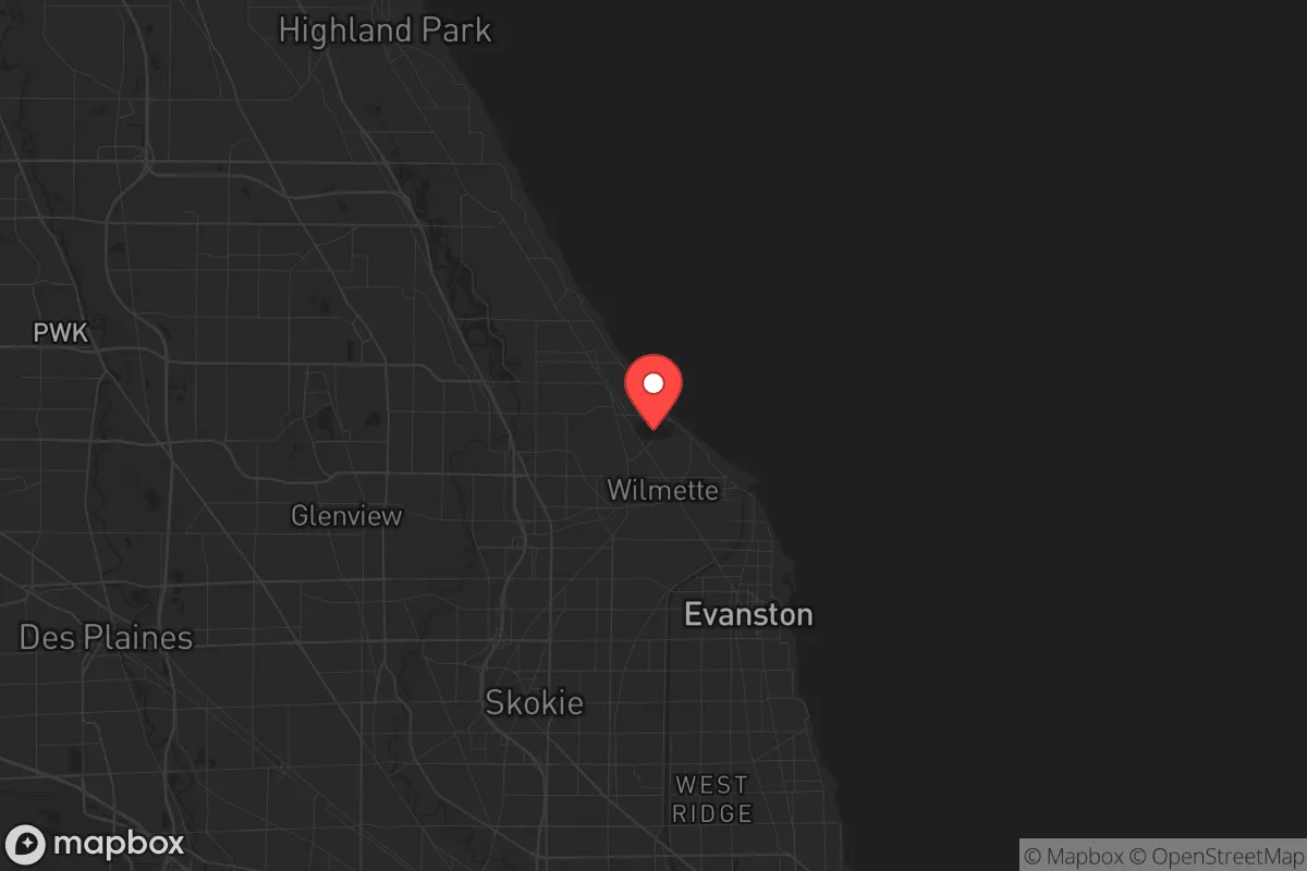
Kenilworth, Illinois, presents a paradox for the strategic relocator: it is a fortress of wealth and order embedded in one of the most politically volatile and logistically vulnerable regions in the Midwest. Its resilience stems not from remote wilderness, but from extreme local wealth, a tiny population (roughly 2,500 residents), and a municipal government that can afford to prioritize security and services over social experimentation. The location advantage is purely defensive in a social sense—this is a place where the rule of law, property rights, and community standards are enforced with a rigor that has largely vanished from surrounding Cook County. For a conservative-leaning individual or family seeking a staging ground rather than a bunker, Kenilworth offers a high-trust, low-crime bubble with immediate access to the economic engine of Chicago, but only if you accept that the bubble’s walls are thin and the surrounding environment is increasingly hostile.
Geographic position and natural advantages for a strategic relocation
Kenilworth sits on a narrow strip of Lake Michigan shoreline, roughly 16 miles north of downtown Chicago, within the North Shore corridor. Its natural advantages are minimal in a survivalist sense—no defensible terrain, no agricultural land, no water source beyond the municipal supply. What it does offer is extreme social insulation. The village is surrounded on three sides by other wealthy North Shore enclaves (Winnetka, Wilmette, Glencoe), creating a contiguous zone of high property values, low crime, and politically conservative-to-moderate governance. The lake provides a psychological and physical eastern boundary, limiting approach vectors. The primary natural asset is the Lake Michigan shoreline, which offers a potential water source (with filtration) and a cooling effect during heat events, but also places the village directly in the path of lake-effect snow and storm surges. The terrain is flat, with no natural cover or elevation advantage. For a prepper, the geographic value is not in the land itself, but in the density of like-minded, resource-rich neighbors who will defend their property and community with legal and financial means. This is a location for those who believe that social cohesion and wealth are the ultimate survival assets, not caves and caches.
Risks, exposures, and proximity to fallout-relevant landmarks
The exposure profile for Kenilworth is dominated by its proximity to Chicago and the critical infrastructure of the region. The most immediate risk is civil unrest spillover. During the 2020 riots, looting and arson occurred in downtown Chicago and spread to affluent suburbs like Oak Park and Evanston. Kenilworth itself was untouched, but the Edens Expressway (I-94) and the Metra Union Pacific North Line run within a mile of the village, providing direct transit routes for disruptive elements from the city. The O'Hare International Airport is 12 miles southwest—a prime target for terrorism, EMP attack, or supply chain disruption. The Argonne National Laboratory is 25 miles southwest, and the Braidwood Generating Station (nuclear) is 50 miles southwest. While not in immediate blast zones, any radiological event would place Kenilworth in the downwind plume path depending on weather patterns. The Skokie Lagoons and Chicago Sanitary and Ship Canal are nearby water infrastructure targets. The village’s dependence on the Chicago water supply is a critical vulnerability—if the Jardine Water Purification Plant is compromised, Kenilworth has no backup. The Glencoe Public Safety Department and Kenilworth Police Department are small (under 20 officers combined), and mutual aid agreements with surrounding suburbs would be strained during a regional crisis. The Edens Plaza shopping center and North Shore Channel are potential chokepoints for evacuation or supply routes.
Practical resilience for a relocator: food, water, energy, and defensibility
For a relocator serious about preparedness, Kenilworth requires a proactive, not passive, resilience strategy. The village has no community gardens, no farmers' markets within walking distance, and no local food production. All food is imported via the Chicago supply chain, which would fail within 72 hours of a major disruption. The nearest grocery stores are in Wilmette and Winnetka, both car-dependent. Water is entirely municipal; a well is not feasible due to the high water table and clay soil. A rainwater catchment system is possible but would require filtration for potable use. Energy is grid-dependent, with no municipal solar or wind installations. Natural gas is the primary heating source, and the pipeline infrastructure is vulnerable to disruption. Defensibility is the weakest point: the village is a flat, open grid of tree-lined streets with no natural barriers. The Kenilworth Club and the Indian Hill Club are large, defensible structures, but they are private and not public shelters. The Kenilworth Assembly Hall could serve as a community rally point. The Lake Michigan beach offers a potential evacuation route by water, but requires a boat. The North Shore Bike Path provides a non-motorized evacuation corridor north to Wisconsin. For a family, the schools are excellent (Joseph Sears School, New Trier High School) and the community is tight-knit, which aids in mutual aid networks. The Kenilworth Historical Society and local churches could serve as communication hubs. The key practical takeaway: stockpile at least 30 days of food and water, install a backup generator (natural gas or propane), and establish a neighborhood watch and communication plan with immediate neighbors. The village’s small size means that social trust is high, but that trust must be converted into a functional preparedness network before a crisis.
The overall strategic picture for Kenilworth is that of a high-value, high-risk staging post. It is not a retreat or a bug-out location; it is a forward operating base for those who need to remain within commuting distance of Chicago for work or family obligations but refuse to live in the city itself. The village’s wealth and social cohesion provide a buffer against the worst of societal decay, but that buffer is thin and dependent on the continued functioning of the regional infrastructure. For a conservative relocator, the calculus is simple: Kenilworth offers the best possible quality of life within a failing system, but it offers no escape from that system. The prudent strategy is to treat Kenilworth as a primary residence with a secondary retreat—a cabin in Wisconsin or Michigan, within a 3-4 hour drive, where supplies and a defensible position are maintained. The village itself is a beautiful, orderly, and safe place to raise a family during normal times, but the prepper must recognize that “normal times” are a luxury that cannot be assumed. If you are willing to invest in local relationships, stockpiles, and a secondary location, Kenilworth can be a viable base. If you are looking for a standalone survival property, look elsewhere. This is a place for those who understand that community is the ultimate survival asset, but also that community must be prepared, not just prosperous.
* Values derived from national, state, county, city and local statistics and may differ in a specific area. Last updated: 2026-04-27T14:44:03.000Z
Narrative content on this page is AI-generated and may contain mistakes. Verify any details that matter before acting on them.
ReloMaps may earn a commission from affiliate links at no extra cost to you.