
Photo: Wikipedia
Strategic Assessment of Makakilo, HI
Meaningful friction. Expect exposure to either population pressure, blast zones, or natural disaster risk. Consider buying a retreat property.
What does the Strategic Assessment tell us?
Our Strategic Assessment grades tactical survivability of an area. Major population centers, military targets, fallout zones, natural disasters, and border exposure all drive risk — lower exposure means a more defensible position in a crisis.
This is heavily inspired by Joel Skousen's Strategic Relocation book. Highly recommended you checkout the book ($)What does this tell us?
Our Strategic Assessment grades tactical survivability of an area. Major population centers, military targets, fallout zones, natural disasters, and border exposure all drive risk — lower exposure means a more defensible position in a crisis.
This is heavily inspired by Joel Skousen's Strategic Relocation book. Highly recommended you checkout the book ($)Strategic Pillars

Key Distances
Regional Safe Places
Below is our recommended "safe zones" in Hawaii and the surrounding area based on our strategic heuristics. For most people, it's unrealistic to live in a “safe zone” full-time due to work, family or other personal reasons. They tend to be more rural. However, many of these areas are perfect for second homes and retreat properties that double as a vacation home or even a short-term rental.


Important Note: For informational purposes only. This does not mean nothing bad ever happens in the green zones. Please use common sense. This is based on public data and modeled with AI. We tried to take a conservative approach but mistakes happen. We update this regularly as new information becomes available.
Solar Generator Recommendations
Backup power matters more here than in safer locations. We've picked three solar generators across budgets and capacity tiers — start with the budget unit if you only need a few essentials, or step up if you want to run a fridge and HVAC for days at a time.

Jackery Portable Power Station Explorer 300
Budget OptionPower on the Go: Weighing only 11 lbs, it's convenient to set up and store with book-sized foldable solar panels

BLUETTI Portable Power Station AC180
Designed for both indoor and outdoor scenarios, AC180 is highly capable as it has a robost capacity and continuous output power.

EF ECOFLOW DELTA Pro Ultra Power Station
Upgraded PickEcoFlow DELTA Pro Ultra is a whole-home energy system designed to grow with your family. Integrated with the Smart Home Panel 2, it scales to meet your evolving energy needs — keeping your home powered, intelligent, and secure through every stage of life.
We earn a commission, at no additional cost to you.
Strategic Assessment Analysis
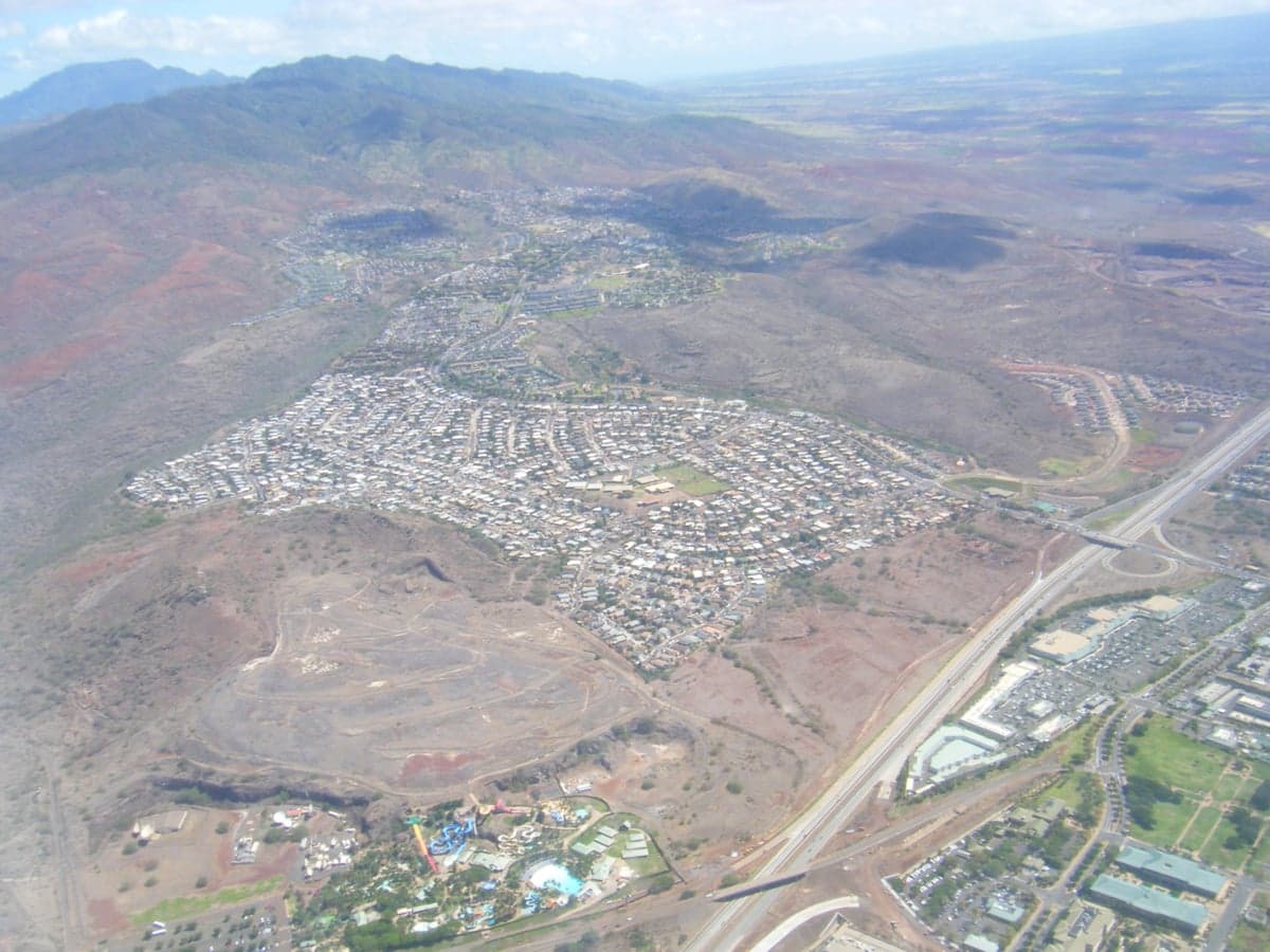
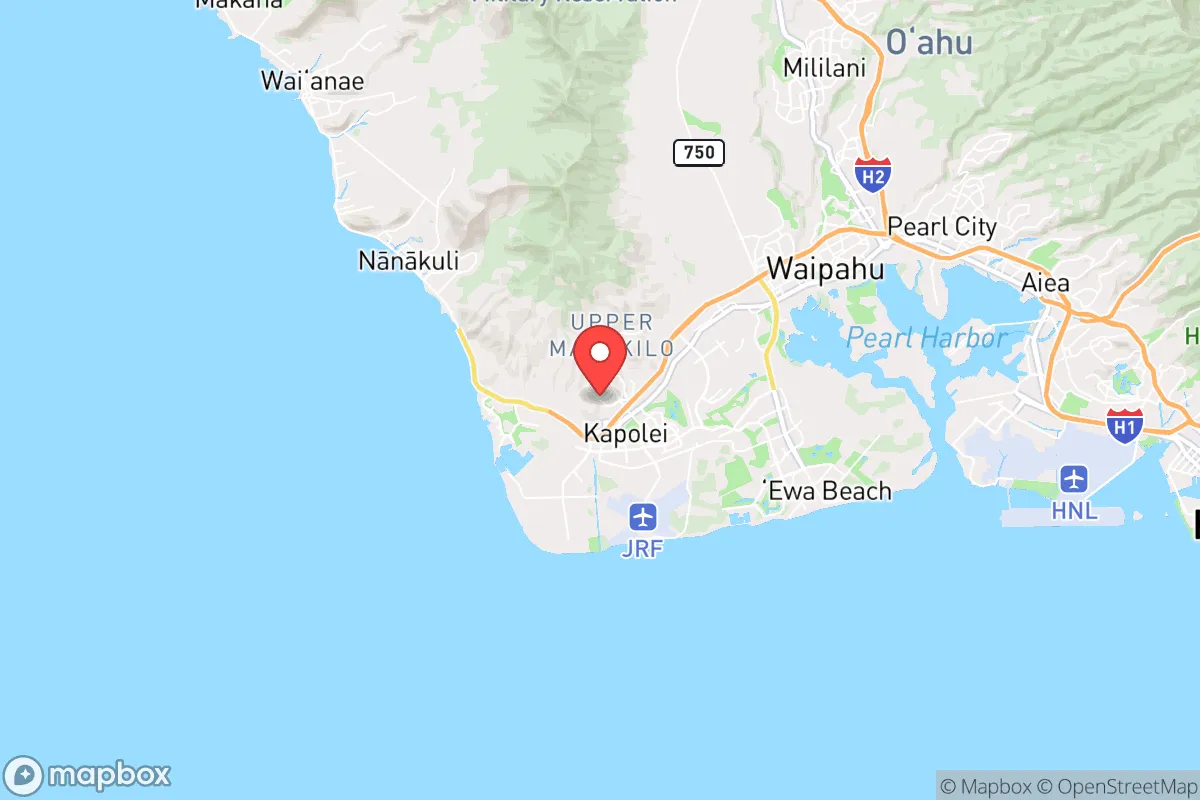
Makakilo, perched on the southwestern slope of Oahu’s Waianae Range, offers a strategic paradox for the prepper-minded relocator: it sits close enough to Honolulu to monitor the pulse of a major urban center, yet its elevation and semi-rural character provide a degree of separation that most island communities lack. For those concerned with civic unrest, mass casualty events, or cascading infrastructure failures, this Kapolei-area neighborhood presents a unique blend of proximity and buffer—but only if you understand the terrain, the choke points, and the hard limits of island life. The key question isn’t whether Makakilo is “safe” in a conventional sense; it’s whether its geographic advantages outweigh the inherent vulnerabilities of being on an island in the Pacific, 2,500 miles from the nearest continent.
Geographic position and natural advantages for long-term security
Makakilo’s primary asset is elevation. At roughly 600 to 800 feet above sea level, the neighborhood sits above the coastal flood zones that threaten much of Oahu’s southern shore, including Ewa Beach and Kapolei. In a tsunami scenario—whether from a distant earthquake or a local landslide—this height provides a natural buffer. The prevailing trade winds also keep temperatures moderate, reducing reliance on air conditioning and lowering the energy footprint for a household. The area’s position on the leeward (dry) side of the island means less rainfall than windward communities, which is a double-edged sword: less mold and rot, but also less natural surface water. For a prepper, the ability to harvest rainwater becomes critical here, as the municipal supply is piped from the Waianae aquifer and vulnerable to both drought and contamination events. Makakilo’s proximity to the H-1 freeway and Farrington Highway gives quick access to Kapolei’s commercial hubs, but those same roads become choke points during an evacuation. The neighborhood’s layout—winding roads, cul-de-sacs, and limited egress points—can be a defensive advantage if you control the access, but a trap if you don’t. The real strategic value lies in its position relative to the Waianae mountain spine: trails and ridgelines to the north offer potential escape routes into less populated areas, though they require serious physical preparation and knowledge of the terrain.
Risks, exposures, and proximity to fallout-relevant landmarks
No analysis of Makakilo is honest without acknowledging the elephant in the room: Oahu is a single-island ecosystem with a single major port (Honolulu Harbor) and a single international airport. Both are within 20 miles of Makakilo, and both are high-value targets in any conflict scenario involving the Pacific theater. Pearl Harbor and Joint Base Pearl Harbor-Hickam are roughly 12 miles east, making the entire southern shore a potential blast or fallout zone in a kinetic event. For the prepper, this proximity is the single greatest liability. A conventional strike, a dirty bomb, or even a major industrial accident at the harbor could render large portions of the island uninhabitable for weeks or months. Makakilo’s elevation does not protect against fallout; prevailing winds from the northeast would carry particulate matter across the island, and the neighborhood’s position on the leeward side offers no guarantee of clean air. Additionally, the area is within the blast radius of the Red Hill fuel storage facility (now defueled but still containing residual contamination), and the nearby Kapolei substation is a critical node in the island’s electrical grid. A coordinated attack on infrastructure could leave Makakilo without power, water, or communications for an extended period. The neighborhood’s population density—roughly 18,000 residents in a compact area—means that any mass evacuation would be chaotic, with the H-1 and Farrington Highway becoming parking lots. For the survivalist, the calculus is clear: Makakilo offers a decent starting position, but it is not a retreat. It is a forward operating base that requires constant awareness of the threats emanating from Honolulu and Pearl Harbor.
Practical resilience for a relocator: food, water, energy, and defensibility
For a single individual or family willing to invest in self-sufficiency, Makakilo has workable but limited options. The soil is rocky and dry, typical of leeward Oahu, making traditional gardening a challenge without raised beds, shade cloth, and significant soil amendment. However, the area’s year-round growing season means that with effort, a household can produce a portion of its own vegetables, particularly drought-tolerant crops like sweet potatoes, beans, and certain greens. Fruit trees—papaya, banana, citrus, and avocado—can thrive with regular watering, but water is the limiting factor. The municipal supply is reliable in normal times, but a grid-down scenario would cut it within hours. Rainwater catchment is legal in Hawaii and should be a top priority for any prepper in Makakilo; a 5,000-gallon tank paired with a metal roof can provide a meaningful buffer. Solar panels are a no-brainer here, given the abundant sun, but battery storage is essential because the grid is fragile and prone to outages during storms or peak demand. Defensibility is mixed: the neighborhood’s layout offers natural chokepoints at the main entrances (Makakilo Drive and Kapolei Parkway), but the area is not remote. Neighbors are close, and a determined group could easily overwhelm a single household. The best strategy is low-profile preparedness—blending in, building relationships with like-minded neighbors, and avoiding conspicuous stockpiling. For those willing to go further, the Waianae Forest Reserve to the north offers potential bug-out locations, but access requires a vehicle capable of rough terrain and a willingness to live off-grid in a humid, mosquito-heavy environment. In short, Makakilo is a viable location for a prepper who treats it as a base of operations, not a final redoubt. It works if you have a plan, a network, and the discipline to maintain supplies for at least 90 days without external support.
The overall strategic picture for Makakilo is one of calculated trade-offs. It offers a defensible elevation, moderate climate, and proximity to Kapolei’s developing infrastructure, but it sits within the shadow of Oahu’s critical military and economic targets. For the conservative-leaning relocator who values community, self-reliance, and a slower pace of life, Makakilo can work—but only if you accept that you are not truly “off the grid.” You are on an island with a single point of failure for resupply, a dense urban population 20 minutes away, and a government that may not prioritize your neighborhood in a crisis. The smart move is to treat Makakilo as a staging area: build your skills, store your supplies, and know your escape routes into the Waianae range or, if feasible, to the neighbor islands. If you are looking for a place to ride out the storm without leaving civilization entirely, Makakilo deserves a look. If you want true isolation and zero proximity to fallout risks, you need to look elsewhere—perhaps the Big Island or a less populated Pacific nation. Makakilo is a compromise, and in the world of strategic relocation, a compromise is only as good as the plan behind it.
* Values derived from national, state, county, city and local statistics and may differ in a specific area. Last updated: 2026-04-24T00:09:51.000Z
Narrative content on this page is AI-generated and may contain mistakes. Verify any details that matter before acting on them.
ReloMaps may earn a commission from affiliate links at no extra cost to you.