
Photo: Wikipedia
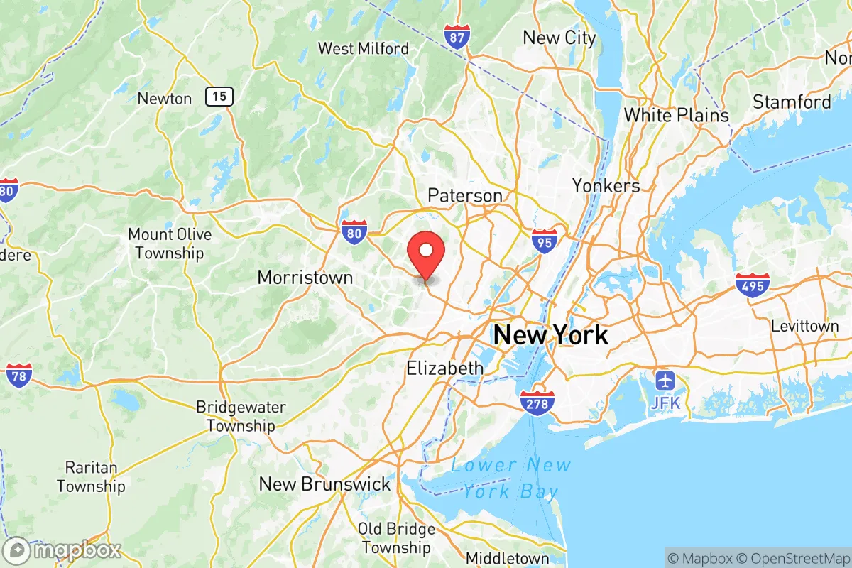
Strategic Assessment of Essex County
High tactical risk. This location is likely close to major population centers, strategic targets, or sits in a high-disaster corridor. A retreat property and careful exit planning is required.
What does the Strategic Assessment tell us?
Our Strategic Assessment grades tactical survivability of an area. Major population centers, military targets, fallout zones, natural disasters, and border exposure all drive risk — lower exposure means a more defensible position in a crisis.
This is heavily inspired by Joel Skousen's Strategic Relocation book. Highly recommended you checkout the book ($)What does this tell us?
Our Strategic Assessment grades tactical survivability of an area. Major population centers, military targets, fallout zones, natural disasters, and border exposure all drive risk — lower exposure means a more defensible position in a crisis.
This is heavily inspired by Joel Skousen's Strategic Relocation book. Highly recommended you checkout the book ($)Strategic Pillars

Key Distances
Strategic Assessment Analysis
Essex County, New Jersey, presents a complex strategic picture for the conservative prepper or survivalist. While its proximity to New York City and dense urban core might seem like a liability, the county’s position within the New York metropolitan area offers a unique blend of access to critical infrastructure and natural buffers that can be leveraged for resilience. The key is understanding that Essex County is not a retreat—it’s a forward operating base, one that requires a clear-eyed assessment of its vulnerabilities and a deliberate plan for self-sufficiency.
Geographic position and natural advantages for long-term survival
Essex County sits roughly 15 miles west of Manhattan, placing it within the blast and fallout zone of any major event targeting the city. However, the county’s geography is more varied than most realize. The western half, particularly towns like West Orange, Verona, and Cedar Grove, rises into the Watchung Mountains, offering higher ground and natural terrain that can slow movement and provide some concealment. The South Mountain Reservation, a 2,000-acre wooded area straddling Millburn and Maplewood, is a critical green space for water collection, foraging, and temporary shelter. The Passaic River runs through the county’s western edge, providing a potential water source—though it’s heavily polluted and would require serious filtration. The Newark Bay and Arthur Kill to the east offer maritime access, but also bring the risk of contamination from industrial spills. For a relocator, the key advantage is the county’s position as a transportation hub: Newark Liberty International Airport and Port Newark are major logistics nodes that, in a crisis, could become chokepoints or supply corridors depending on who controls them.
Risks, exposures, and proximity to fallout-relevant landmarks
Essex County is ringed by high-value targets. Newark itself hosts the Port Newark–Elizabeth Marine Terminal, one of the busiest container ports on the East Coast, and the Newark Bay Refinery (operated by Phillips 66) is a major petrochemical facility. A strike or accident at either would release toxic clouds and create a long-term exclusion zone. The PSEG power plant in Newark and the Linden Cogeneration Plant just south in Union County are additional industrial risks. To the east, Staten Island’s Fresh Kills landfill and the Bayonne Bridge are potential targets. The Hudson River tunnels and PATH train system are critical infrastructure that, if compromised, could strand thousands. For the prepper, the biggest concern is the Newark–Elizabeth–Jersey City corridor, which concentrates millions of people within a 10-mile radius. In a mass casualty event or civil unrest, this population density would create a humanitarian crisis, with Essex County serving as both a refuge and a funnel for displaced persons. The Garden State Parkway and Interstate 280 would become clogged escape routes. The Newark Penn Station and Broad Street Station are rail hubs that could be targeted or overwhelmed.
Practical resilience for a relocator: food, water, energy, and defensibility
Self-sufficiency in Essex County is challenging but not impossible. Water is the first concern: the Passaic River is the primary surface source, but it’s contaminated with industrial runoff and sewage. The Wanaque Reservoir in neighboring Passaic County and the Newark Watershed in the northern part of the county are better bets, but they’re controlled by municipal utilities. A prepper should plan for at least two weeks of stored water and a high-quality filtration system (e.g., Berkey or reverse osmosis). Food is a mixed bag: the county has some farmland in the western townships, but most of it is suburban. Community gardens exist in Montclair and South Orange, but they’re not scalable for long-term survival. The Newark Farmers Market and local CSAs are options, but they rely on supply chains that could break. Energy is a vulnerability: the grid is old and prone to outages, especially during storms. Solar panels with battery storage are a wise investment, but many HOAs in affluent towns like Glen Ridge or Millburn restrict them. Natural gas is widely available, but a disruption would leave homes without heat or cooking fuel. Defensibility is the hardest factor. Essex County is not a rural redoubt; it’s a patchwork of dense suburbs and urban centers. The best defensive positions are in the Watchung Mountains near Verona or West Orange, where terrain provides natural chokepoints. A rural property with acreage is rare and expensive—expect to pay $800,000+ for a house with land. For the single individual or family, the strategy should be to establish a secure home base with multiple egress routes, a cache of supplies, and a network of trusted neighbors. The Essex County Sheriff’s Office and local police are generally professional, but in a collapse scenario, they’ll be overwhelmed.
The overall strategic picture for Essex County is one of high risk but also high potential reward for the prepared relocator. It’s not a place to hunker down indefinitely—the population density and industrial targets make that untenable. But as a staging area for a longer-term move to the Poconos or Upstate New York, it offers unmatched access to resources, transportation, and information. The conservative prepper should view Essex County as a temporary base, not a final destination. The key is to have a bug-out plan that leverages the county’s western high ground and the Route 80 corridor west toward the Delaware Water Gap. If you can secure a property in the Watchungs, stockpile supplies, and build a local network, Essex County can serve as a resilient forward position. But if the grid goes down and the cities burn, the smart move is to head west—and fast.
* Values derived from national, state, county, city and local statistics and may differ in a specific area. Last updated: 2026-05-12T00:42:13.000Z
Narrative content on this page is AI-generated and may contain mistakes. Verify any details that matter before acting on them.
ReloMaps may earn a commission from affiliate links at no extra cost to you.