Photo: Wikipedia
Strategic Assessment of Greene County
Meaningful friction. Expect exposure to either population pressure, blast zones, or natural disaster risk. Consider buying a retreat property.
What does the Strategic Assessment tell us?
Our Strategic Assessment grades tactical survivability of an area. Major population centers, military targets, fallout zones, natural disasters, and border exposure all drive risk — lower exposure means a more defensible position in a crisis.
This is heavily inspired by Joel Skousen's Strategic Relocation book. Highly recommended you checkout the book ($)What does this tell us?
Our Strategic Assessment grades tactical survivability of an area. Major population centers, military targets, fallout zones, natural disasters, and border exposure all drive risk — lower exposure means a more defensible position in a crisis.
This is heavily inspired by Joel Skousen's Strategic Relocation book. Highly recommended you checkout the book ($)Strategic Pillars

Key Distances
Strategic Assessment Analysis
Greene County, Ohio, sits in a sweet spot that few relocation analysts fully appreciate: close enough to the economic engine of Dayton and Cincinnati to matter, but far enough from their urban cores to dodge the worst of what's coming. This is not a place that will make headlines for its prepper cachet, but it offers a quiet, defensible position for those who understand that resilience is about logistics, not just stockpiles. The county's agricultural base, its position along the I-75 corridor, and its distance from the most obvious fallout targets make it a viable fallback zone for single individuals and families who want to be prepared without living off-grid in a bunker.
Geographic position and natural advantages for long-term stability
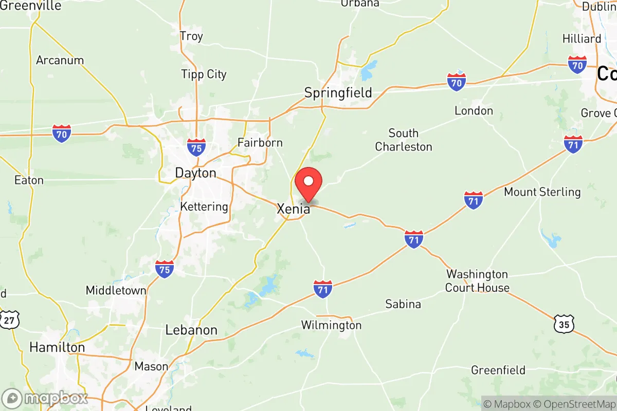
Greene County anchors the southwestern edge of Ohio's Miami Valley, a region defined by the Little Miami and Great Miami Rivers. The terrain is rolling farmland with scattered woodlots—not mountainous, but not flat enough to be a floodplain nightmare. The county seat is Xenia, a town of about 26,000 that sits roughly 15 miles east of Dayton and 50 miles north of Cincinnati. This puts it outside the immediate blast radius of any major urban target, but within a two-hour drive of Wright-Patterson Air Force Base, a primary military installation that could become a logistical hub or a target depending on the scenario. The natural advantages here are water and soil. The Little Miami River runs through the eastern part of the county, and the aquifer beneath the region is robust. For a relocator thinking about long-term food security, the surrounding farmland is some of the most productive in the state—corn, soybeans, and livestock operations dominate. The climate is temperate, with four distinct seasons, which means no single weather event (drought, hurricane, blizzard) is likely to cripple the area for more than a few weeks.
Risks, exposures, and proximity to fallout-relevant landmarks
No strategic assessment is honest without naming the liabilities. Greene County's biggest exposure is its proximity to Wright-Patterson Air Force Base, located just west of the county line in Montgomery County. Wright-Patt is the headquarters of the Air Force Materiel Command and a major research and logistics hub. In a conflict scenario—whether conventional war or a major terrorist event—this base is a high-value target. The fallout zone from a conventional strike or a dirty bomb at Wright-Patt would likely extend into eastern Greene County, particularly around Xenia and Beavercreek, a suburb of 48,000 that sits directly adjacent to the base. The I-75 corridor, which runs through the western edge of the county, is another vulnerability. In a mass evacuation or civil unrest event, that highway becomes a choke point. The county also has a small but active rail line running through Xenia, which could be a vector for hazardous material spills or targeted disruption. On the plus side, Greene County has no major refineries, chemical plants, or nuclear power stations within its borders. The closest nuclear facility is the Davis-Besse Nuclear Power Station near Toledo, about 150 miles north—far enough to be irrelevant for fallout. The Port of Cincinnati is about 60 miles south, but that's a river port, not a deepwater target. The real risk is not a direct hit; it's the secondary effects of a strike on Wright-Patt or the chaos spilling out of Dayton and Cincinnati.
Practical resilience for a relocator: food, water, energy, and defensibility
For a single individual or a family looking to set up a resilient household, Greene County offers a mix of suburban and rural options. The rural townships—Bath Township, Miami Township, and Caesarscreek Township—have larger lots, well water, and septic systems, which means you are not dependent on municipal infrastructure. The county's water table is generally reliable, and many rural properties have existing wells. For energy, the grid is typical Midwest: reliable in normal times, but vulnerable to ice storms and cyber attacks. Solar is viable here—the region gets about 180 sunny days per year, which is average for Ohio—but battery storage is essential if you want to ride out a multi-day outage. Natural gas is widely available in suburban areas, and propane is common in rural zones. For food security, the local agricultural network is a genuine asset. The Greene County Farmers Market in Xenia operates year-round, and there are dozens of small farms within a 20-minute drive that sell direct to consumers. The county also has a strong hunting culture—deer and turkey are abundant—and fishing in the Little Miami River is decent. Defensibility is the weak point. Greene County is not a natural fortress. The terrain is open farmland with scattered tree lines, which means long sightlines but limited cover. A rural property with a good perimeter—fencing, natural barriers, a clear view of approach roads—is far more defensible than a suburban lot in Beavercreek or Fairborn. Fairborn, with a population of about 33,000, is the most densely populated part of the county and sits right on the edge of Wright-Patt. For a prepper, that's a zone to avoid. The ideal setup is a rural property in the eastern or southern part of the county, away from the major roads and the base.
The overall strategic picture for Greene County is one of calculated trade-offs. It is not a remote survivalist paradise—you will have neighbors, and you will be within an hour of two major cities. But that proximity also means access to medical care, hardware stores, and a local economy that won't collapse overnight. The county's political leanings are mixed: Xenia and the rural areas lean conservative, while Beavercreek and Fairborn are more purple. For a conservative-leaning relocator, the culture is generally welcoming, with a strong sense of local community and a low tolerance for the kind of urban dysfunction that is driving people out of cities like Dayton and Cincinnati. The bottom line: Greene County is a solid B+ relocation choice for someone who wants to be prepared but not isolated. It offers water, food, and a defensible rural option, but you must account for the Wright-Patt risk and the I-75 corridor. If you can secure a property in the eastern townships, with a well, solar, and a good perimeter, you will be in a position to ride out most scenarios—short of a direct strike on the base. And if that happens, nowhere in the region is safe anyway.
* Values derived from national, state, county, city and local statistics and may differ in a specific area. Last updated: 2026-05-28T09:31:32.000Z
Narrative content on this page is AI-generated and may contain mistakes. Verify any details that matter before acting on them.
ReloMaps may earn a commission from affiliate links at no extra cost to you.