
Photo: Wikipedia
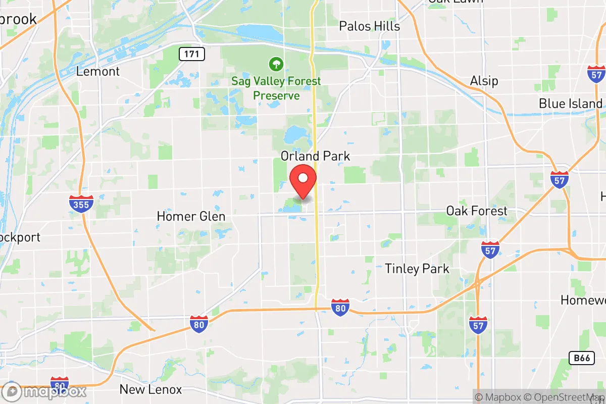
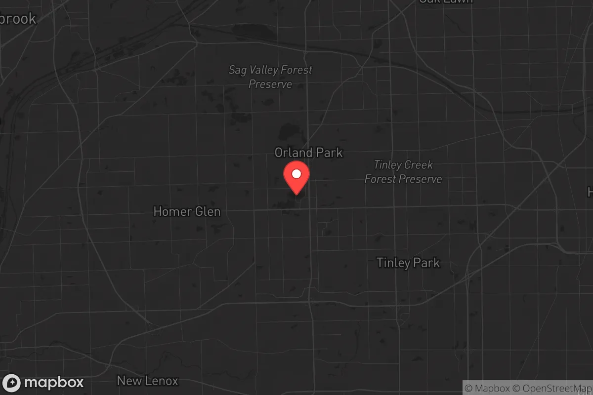
Strategic Assessment of Orland Park, IL
Multiple tactical vulnerabilities. Population density, target proximity, or disaster risk are likely compounding. A retreat property and exit planning is required.
What does the Strategic Assessment tell us?
Our Strategic Assessment grades tactical survivability of an area. Major population centers, military targets, fallout zones, natural disasters, and border exposure all drive risk — lower exposure means a more defensible position in a crisis.
This is heavily inspired by Joel Skousen's Strategic Relocation book. Highly recommended you checkout the book ($)What does this tell us?
Our Strategic Assessment grades tactical survivability of an area. Major population centers, military targets, fallout zones, natural disasters, and border exposure all drive risk — lower exposure means a more defensible position in a crisis.
This is heavily inspired by Joel Skousen's Strategic Relocation book. Highly recommended you checkout the book ($)Strategic Pillars

Key Distances
Regional Safe Places
Below is our recommended "safe zones" in Illinois and the surrounding area based on our strategic heuristics. For most people, it's unrealistic to live in a “safe zone” full-time due to work, family or other personal reasons. They tend to be more rural. However, many of these areas are perfect for second homes and retreat properties that double as a vacation home or even a short-term rental.
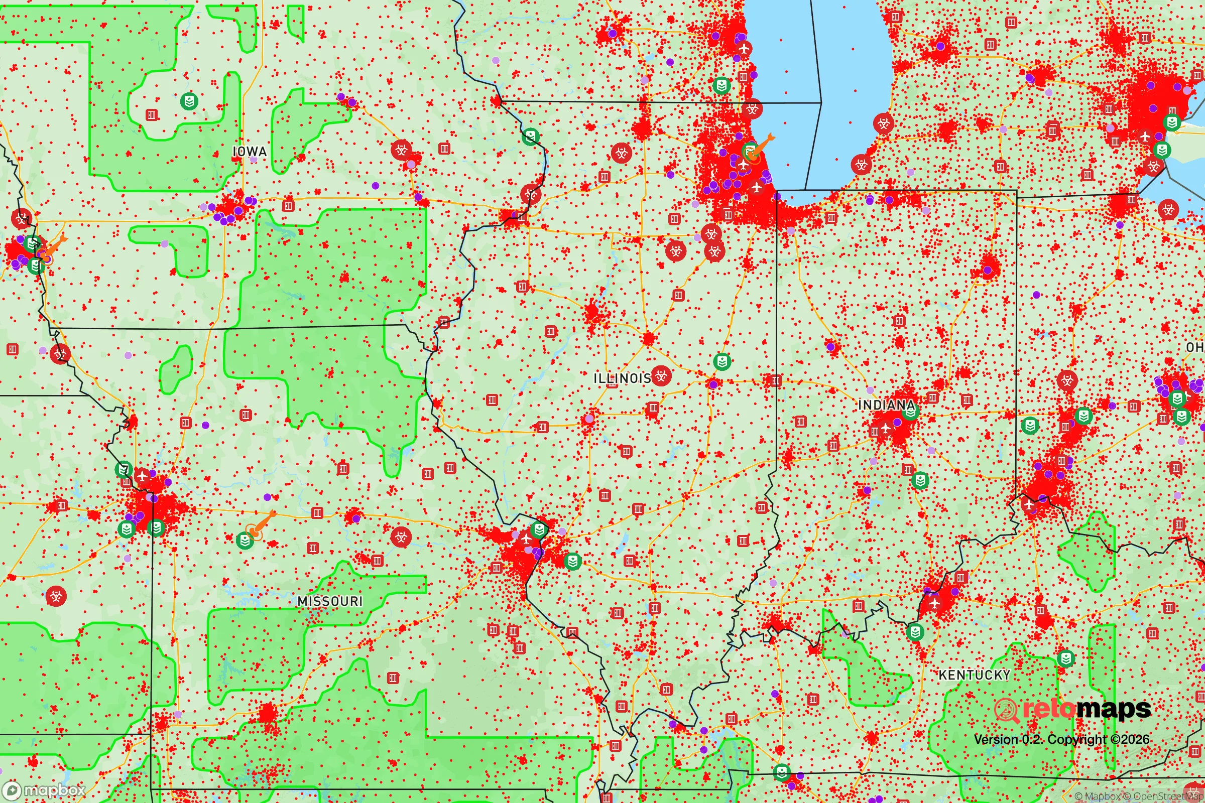
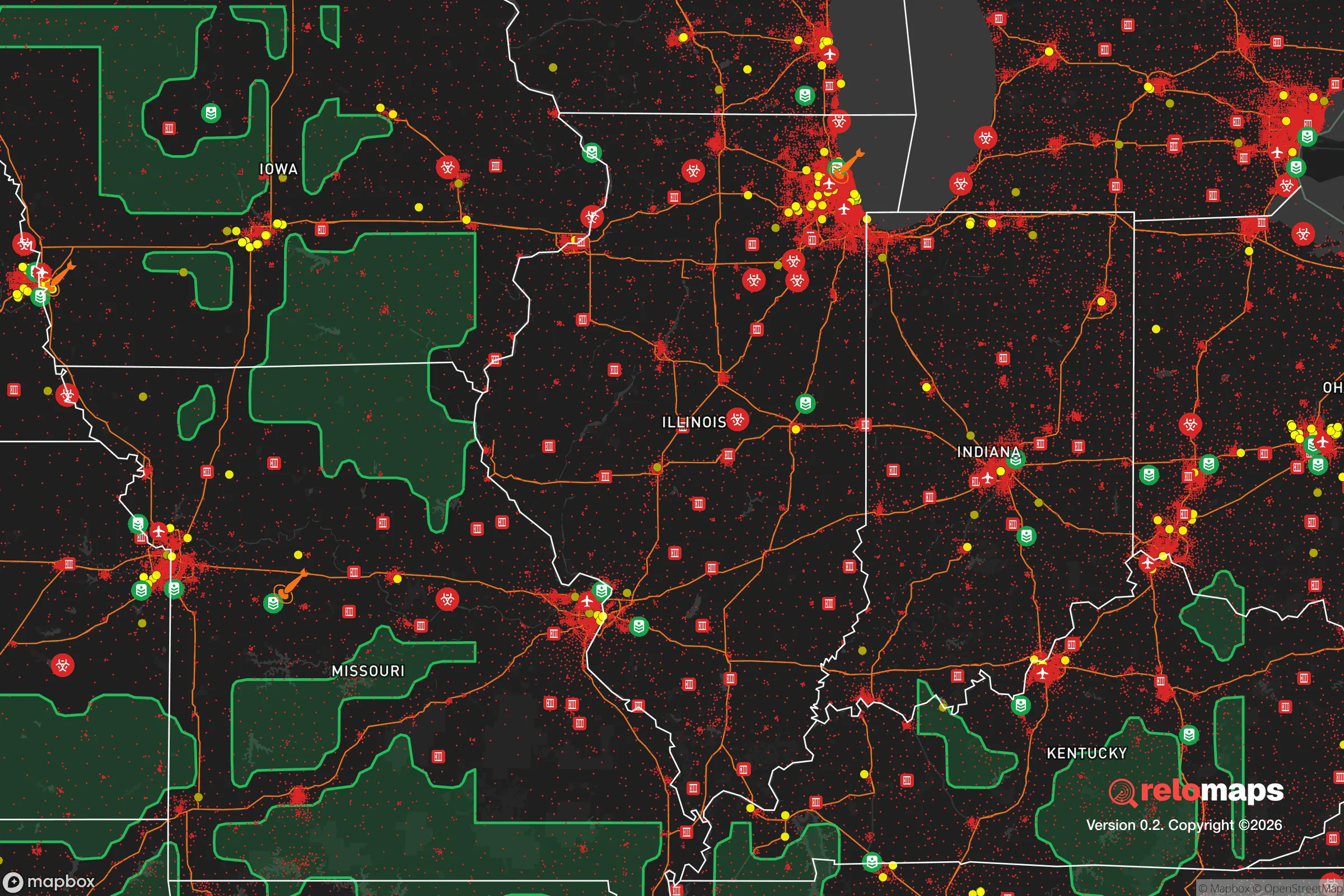
Important Note: For informational purposes only. This does not mean nothing bad ever happens in the green zones. Please use common sense. This is based on public data and modeled with AI. We tried to take a conservative approach but mistakes happen. We update this regularly as new information becomes available.
Solar Generator Recommendations
Backup power matters more here than in safer locations. We've picked three solar generators across budgets and capacity tiers — start with the budget unit if you only need a few essentials, or step up if you want to run a fridge and HVAC for days at a time.

Jackery Portable Power Station Explorer 300
Budget OptionPower on the Go: Weighing only 11 lbs, it's convenient to set up and store with book-sized foldable solar panels

BLUETTI Portable Power Station AC180
Designed for both indoor and outdoor scenarios, AC180 is highly capable as it has a robost capacity and continuous output power.

EF ECOFLOW DELTA Pro Ultra Power Station
Upgraded PickEcoFlow DELTA Pro Ultra is a whole-home energy system designed to grow with your family. Integrated with the Smart Home Panel 2, it scales to meet your evolving energy needs — keeping your home powered, intelligent, and secure through every stage of life.
We earn a commission, at no additional cost to you.
Strategic Assessment Analysis
Orland Park, Illinois, sits roughly 25 miles southwest of Chicago’s Loop, a position that offers a mixed bag for anyone thinking long-term about resilience. On one hand, you’re close enough to a major metro to access supply chains, medical centers, and job markets; on the other, that proximity introduces real risks tied to civil unrest, infrastructure strain, and the fallout from a major event. The village itself has a population around 58,000, with a median household income near $90,000 and a housing stock that leans heavily toward single-family homes on quarter-acre lots—factors that give it a more suburban, spread-out feel than denser inner-ring suburbs. For a relocator with a prepper mindset, the key question is whether Orland Park’s advantages—good schools, low violent crime, and decent road access—outweigh the vulnerabilities that come with being in the Chicago orbit. The answer depends heavily on your threat model and how much you’re willing to trade convenience for security.
Geographic position and natural advantages for long-term stability
Orland Park’s geography is defined by its location on the Valparaiso Moraine, a ridge of glacial till that gives the area slightly higher elevation than much of Cook County—roughly 700 feet above sea level. That elevation matters for drainage and flood risk; the village sits outside the major floodplains of the Des Plaines and Calumet river systems, which means less worry about water damage during heavy rain events. The surrounding landscape is a patchwork of forest preserves—the Cook County Forest Preserve District manages over 2,000 acres within a few miles of the village center, including the 1,200-acre Cap Sauers Holdings and the 800-acre Swallow Cliff Woods. These green spaces provide natural buffers, wildlife corridors, and potential sources of firewood and game in a prolonged grid-down scenario. The soil is primarily silty clay loam, which is workable for small-scale gardening if you’re willing to amend it with compost, though the growing season is short—roughly 150 days between last and first frost. Water access is a mixed bag: the village draws from Lake Michigan via the Chicago water system, which means you’re dependent on a centralized infrastructure that could be disrupted by a cyberattack or physical sabotage. Private wells are rare in the developed areas, but some of the newer subdivisions on the village’s western edge have access to deeper aquifers. For a relocator, the natural advantages here are modest but real—decent elevation, good tree cover, and proximity to open land—but they don’t compare to more remote areas in the Driftless Region or the Ozarks.
Risks, exposures, and proximity to fallout-relevant landmarks
The biggest liability for Orland Park is its location within the Chicago metropolitan area, a region of roughly 9.5 million people. In a major civil unrest scenario—say, a contested election, a currency collapse, or a pandemic resurgence—the village sits directly in the path of any southward or southwestward movement from the city. The major evacuation routes are Interstate 57 and U.S. Route 45 (LaGrange Road), both of which can gridlock within minutes during a crisis. Orland Park is also within 10 miles of the Argonne National Laboratory in Lemont, a nuclear research facility that, while well-guarded, could become a target for sabotage or a source of panic if something goes wrong. The village is roughly 30 miles from Chicago’s O’Hare and Midway airports, both of which are potential ground-zero for a terrorist attack or a pandemic-spreading event. On the industrial side, the area is ringed by chemical plants, refineries, and rail yards—the ExxonMobil Joliet refinery is about 20 miles southwest, and the Union Pacific rail line that runs through Orland Park carries hazardous materials daily. For a prepper, these are not theoretical risks; they’re concrete exposures that could turn a bad day into a catastrophic one. The village’s police department has about 100 sworn officers, which is decent for a suburb its size, but they’d be stretched thin in a regional emergency. The fire department is combination career-volunteer, with three stations, but mutual aid agreements with neighboring towns could be unreliable if everyone is overwhelmed. In short, Orland Park is not a bunker—it’s a suburb with all the vulnerabilities that come with being part of a massive, interconnected urban system.
Practical resilience for a relocator: food, water, energy, and defensibility
For someone looking to set up a resilient household in Orland Park, the practical picture is mixed. Food security is achievable but requires work: the village has two major grocery chains—Jewel-Osco and Mariano’s—plus a Costco in nearby Tinley Park, but these are just-in-time supply chains that can empty out in hours during a panic. The local farmers’ market runs June through October, and there are a handful of small farms in Will County to the south that could be tapped for direct purchases, but you’re not going to subsist on local produce alone. Gardening is possible on a typical quarter-acre lot, but you’ll need raised beds and a plan for pests like deer and rabbits, which are abundant in the forest preserves. Water storage is a must: the municipal supply is treated and reliable in normal times, but a prolonged power outage would shut down the pumping stations. A 55-gallon drum per person, plus a Berkey filter or similar, would give you a two-week buffer. Energy resilience is easier: the village has no HOA restrictions on solar panels in most subdivisions, and a small 2-3 kW system with battery backup could keep a fridge, lights, and a radio running indefinitely. Natural gas is the primary heating fuel, and while the grid is stable, a winter storm like the 2011 polar vortex could knock it out for days. A wood stove or a propane heater with proper ventilation is a smart addition. Defensibility is the weak point: Orland Park is a typical suburban grid of cul-de-sacs and arterial roads, with no natural chokepoints or high ground. Your best bet is a house on a corner lot with good sightlines, reinforced doors, and a plan for neighborhood mutual aid. The village’s crime rate is low—violent crime is about 1.5 per 1,000 residents, well below the national average—but that’s a peacetime statistic. In a breakdown, the density of houses and the number of entry points make it hard to secure a perimeter.
Overall, Orland Park is a reasonable choice for a relocator who wants to stay within striking distance of Chicago’s resources while maintaining a suburban lifestyle, but it’s not a survivalist’s paradise. The location offers decent natural buffers and a low baseline crime rate, but the proximity to a major city, critical infrastructure, and potential fallout zones means you’re trading long-term security for short-term convenience. If your threat model is a localized event—a tornado, a week-long power outage, a temporary supply chain disruption—Orland Park can handle it with moderate preparation. If you’re planning for a full-scale societal collapse, a pandemic, or a war, you’d be better off looking at rural areas in southern Illinois or the Upper Peninsula. The village’s best use case is as a staging ground: a place to build skills, store supplies, and network with like-minded people while you scout a more remote property. It’s not a final destination, but it’s a defensible waypoint for someone who wants to be prepared without going off-grid entirely.
* Values derived from national, state, county, city and local statistics and may differ in a specific area. Last updated: 2026-04-23T12:19:05.000Z
Narrative content on this page is AI-generated and may contain mistakes. Verify any details that matter before acting on them.
ReloMaps may earn a commission from affiliate links at no extra cost to you.