
Photo: Wikipedia
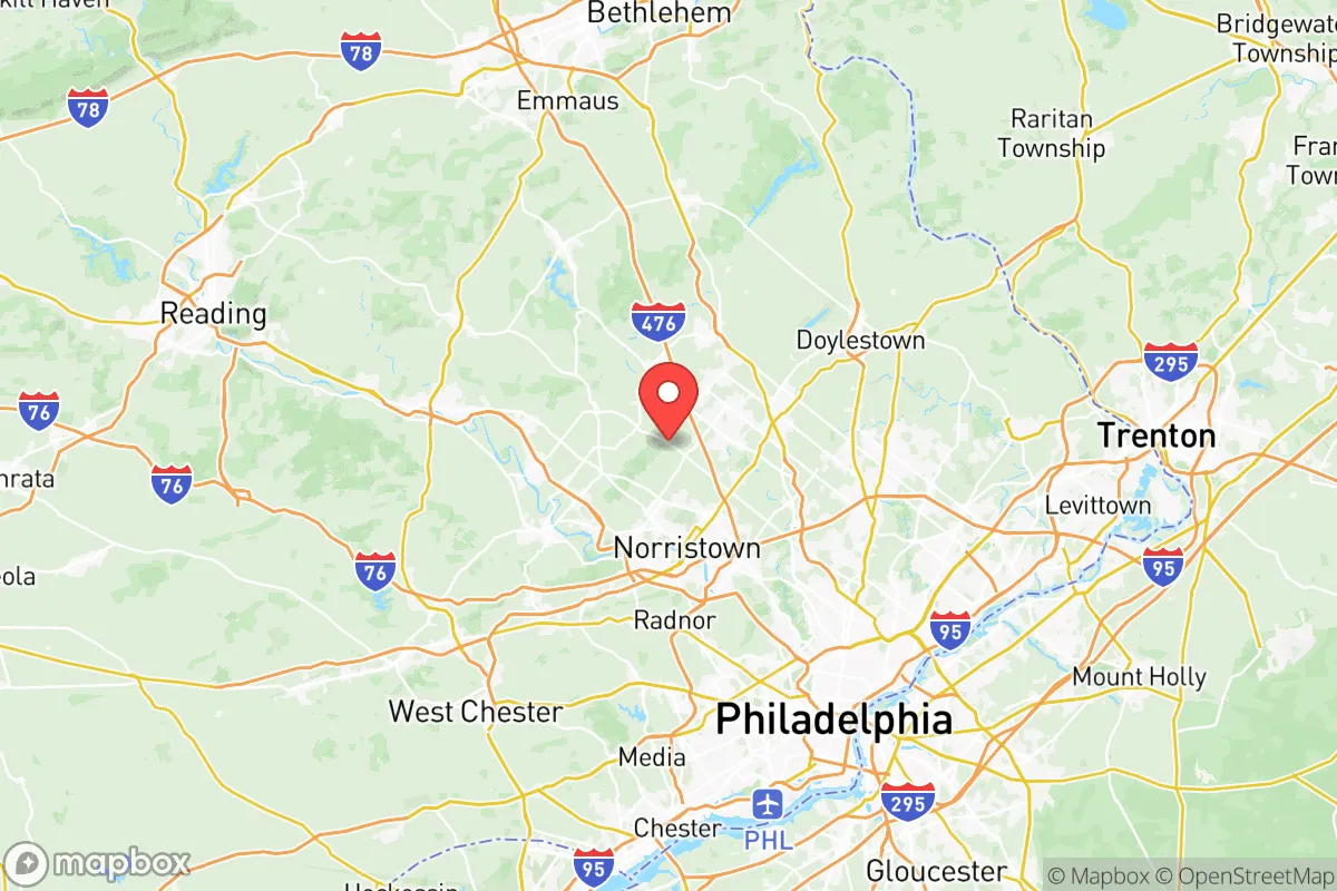
Strategic Assessment of Montgomery County
Multiple tactical vulnerabilities. Population density, target proximity, or disaster risk are likely compounding. A retreat property and exit planning is required.
What does the Strategic Assessment tell us?
Our Strategic Assessment grades tactical survivability of an area. Major population centers, military targets, fallout zones, natural disasters, and border exposure all drive risk — lower exposure means a more defensible position in a crisis.
This is heavily inspired by Joel Skousen's Strategic Relocation book. Highly recommended you checkout the book ($)What does this tell us?
Our Strategic Assessment grades tactical survivability of an area. Major population centers, military targets, fallout zones, natural disasters, and border exposure all drive risk — lower exposure means a more defensible position in a crisis.
This is heavily inspired by Joel Skousen's Strategic Relocation book. Highly recommended you checkout the book ($)Strategic Pillars

Key Distances
Strategic Assessment Analysis
Montgomery County, Pennsylvania, presents a complex strategic picture for the conservative relocator focused on resilience. While it sits in the densely populated Northeast Corridor, its specific geography, infrastructure, and demographic makeup offer a mix of genuine advantages and significant liabilities that demand careful consideration. This is not a rural retreat, but a suburban staging ground—one that requires a clear-eyed assessment of its position relative to major population centers, critical infrastructure, and potential fallout zones.
Geographic position and natural advantages for long-term stability
Montgomery County occupies a strategic position northwest of Philadelphia, forming a buffer between the urban core and the more rural counties of Berks and Lehigh. Its location along the Schuylkill River and its proximity to the Pennsylvania Turnpike (I-276) and the Northeast Extension (I-476) provide critical transportation redundancy. For a relocator, this means multiple egress routes away from Philadelphia in the event of civil unrest or a major disaster. The county’s northern and western townships—such as Upper Perkiomen Valley, Salford, and Marlborough—offer a mix of farmland, wooded hills, and smaller communities that are more defensible and less dependent on centralized infrastructure than the dense suburbs closer to the city. The region’s natural water supply is robust, with the Schuylkill River and its tributaries (Perkiomen Creek, Wissahickon Creek) providing surface water sources, though treatment and access are key concerns. The terrain is rolling hills and valleys, which can offer natural cover and line-of-sight advantages for a prepared individual, but also limits large-scale agriculture compared to the Midwest. The climate is temperate, with four distinct seasons, meaning winter preparedness (heating, fuel, snow removal) is a non-negotiable part of any resilience plan here.
Risks, exposures, and proximity to fallout-relevant landmarks
The most significant strategic liability of Montgomery County is its proximity to high-value, high-risk targets. Philadelphia, just 20 miles southeast, is a major population center, a hub for federal agencies, and a potential flashpoint for civil unrest. The county itself contains critical infrastructure that could become a secondary target or a source of cascading failure. The Limerick Generating Station, a nuclear power plant in the southeastern part of the county near Pottstown, is a primary concern. A major incident there—whether accidental or deliberate—would render large portions of the county uninhabitable for an extended period. The prevailing winds typically blow from the west, meaning fallout from a Philadelphia event could drift into the county, but a Limerick event would be a localized catastrophe. Additionally, the county is crisscrossed by major natural gas pipelines (including the Mariner East pipeline system) and electrical transmission corridors. The Valley Forge National Historical Park area, while historically significant, is also a major transportation node and a potential staging ground for federal response, which could attract unwanted attention. The presence of Fort Detrick in nearby Frederick, Maryland, and Naval Support Activity Mechanicsburg in central Pennsylvania, while not directly in the county, means the region is within a broader military and research corridor that could be a target. For the prepper, the concentration of population and infrastructure in the southeastern part of the county (Lower Merion, Abington, Cheltenham) is a clear negative—these areas are too close to Philadelphia and too dependent on fragile supply chains. The northern and western townships offer better standoff distance, but they are still within a 30- to 60-minute drive of these risks.
Practical resilience for a relocator: food, water, energy, and defensibility
For a single individual or family looking to establish a resilient foothold, Montgomery County offers a mixed bag. Food security is achievable but requires effort. The county has a strong agricultural presence in its northern half, with farms in the Perkiomen Valley and around Green Lane providing local produce, dairy, and meat. Farmers' markets are common, and the Amish and Mennonite communities in neighboring Lancaster and Chester counties are within a reasonable drive. However, the county is not a net food producer—it relies heavily on trucked-in supplies from the broader region. A relocator should prioritize establishing relationships with local farmers and consider a home garden and food storage plan. Water security is a more favorable picture. The Schuylkill River is a major water source, but it is also a vector for contamination from upstream industrial sites and agricultural runoff. Private wells in the northern townships are a better option, but require testing and maintenance. Rainwater collection is viable, but local regulations may restrict it. Energy independence is a challenge. The grid is reliable in normal times but vulnerable to weather events (ice storms, hurricanes) and cyberattacks. Solar panels with battery backup are a strong option, as the county receives adequate sunlight. Wood heat is a practical supplement in the northern areas, where firewood is available. Defensibility varies dramatically by location. A property on a dead-end road in a rural township like Upper Hanover or Douglass offers far better security than a suburban cul-de-sac in Norristown or King of Prussia. The county’s suburban sprawl means that many neighborhoods are interconnected by roads and trails, making them difficult to secure. The ideal property would be on a minimum of 5-10 acres, with good sightlines, a reliable water source, and a defensible perimeter. The local gun culture is present but not as dominant as in rural Pennsylvania; the county has a mix of conservative and liberal enclaves, so a relocator should be discreet about their preparations.
The overall strategic picture for Montgomery County is one of calculated risk. It is not a survivalist paradise, but it is not a death trap either. The northern and western townships offer a viable compromise: proximity to the economic and medical resources of the Philadelphia region, while maintaining enough distance and rural character to allow for meaningful self-sufficiency. The key is to avoid the dense, infrastructure-dependent suburbs and instead focus on the less developed areas where a prepared individual can establish a resilient property. The presence of the Limerick nuclear plant and the proximity to Philadelphia are real, non-negotiable risks that must be factored into any plan. For the conservative relocator who values community, self-reliance, and a strategic position within the Northeast, Montgomery County can work—but only if you choose your exact location with the same care you would a defensive position. It is a staging area, not a final redoubt.
* Values derived from national, state, county, city and local statistics and may differ in a specific area. Last updated: 2026-05-17T00:56:59.000Z
Narrative content on this page is AI-generated and may contain mistakes. Verify any details that matter before acting on them.
ReloMaps may earn a commission from affiliate links at no extra cost to you.