
Photo: Wikipedia
Strategic Assessment of Redmond, WA
Multiple tactical vulnerabilities. Population density, target proximity, or disaster risk are likely compounding. A retreat property and exit planning is required.
What does the Strategic Assessment tell us?
Our Strategic Assessment grades tactical survivability of an area. Major population centers, military targets, fallout zones, natural disasters, and border exposure all drive risk — lower exposure means a more defensible position in a crisis.
This is heavily inspired by Joel Skousen's Strategic Relocation book. Highly recommended you checkout the book ($)What does this tell us?
Our Strategic Assessment grades tactical survivability of an area. Major population centers, military targets, fallout zones, natural disasters, and border exposure all drive risk — lower exposure means a more defensible position in a crisis.
This is heavily inspired by Joel Skousen's Strategic Relocation book. Highly recommended you checkout the book ($)Strategic Pillars

Key Distances
Regional Safe Places
Below is our recommended "safe zones" in Washington and the surrounding area based on our strategic heuristics. For most people, it's unrealistic to live in a “safe zone” full-time due to work, family or other personal reasons. They tend to be more rural. However, many of these areas are perfect for second homes and retreat properties that double as a vacation home or even a short-term rental.


Important Note: For informational purposes only. This does not mean nothing bad ever happens in the green zones. Please use common sense. This is based on public data and modeled with AI. We tried to take a conservative approach but mistakes happen. We update this regularly as new information becomes available.
Solar Generator Recommendations
Backup power matters more here than in safer locations. We've picked three solar generators across budgets and capacity tiers — start with the budget unit if you only need a few essentials, or step up if you want to run a fridge and HVAC for days at a time.

Jackery Portable Power Station Explorer 300
Budget OptionPower on the Go: Weighing only 11 lbs, it's convenient to set up and store with book-sized foldable solar panels

BLUETTI Portable Power Station AC180
Designed for both indoor and outdoor scenarios, AC180 is highly capable as it has a robost capacity and continuous output power.

EF ECOFLOW DELTA Pro Ultra Power Station
Upgraded PickEcoFlow DELTA Pro Ultra is a whole-home energy system designed to grow with your family. Integrated with the Smart Home Panel 2, it scales to meet your evolving energy needs — keeping your home powered, intelligent, and secure through every stage of life.
We earn a commission, at no additional cost to you.
Strategic Assessment Analysis
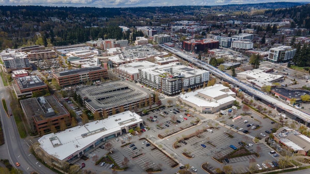
Redmond, Washington presents a deeply conflicted picture for the strategic relocator. On one hand, its position in the Pacific Northwest offers abundant fresh water, moderate climate, and defensible terrain. On the other, it sits squarely in the shadow of a major metropolitan area, a global tech hub, and multiple high-value targets that would make it a dangerous place to be during any large-scale disruption. For a conservative-minded individual or family prioritizing long-term resilience, Redmond is not a retreat—it is a forward operating base with significant liabilities that must be fully understood before any relocation decision.
Geographic position and natural advantages for long-term survival
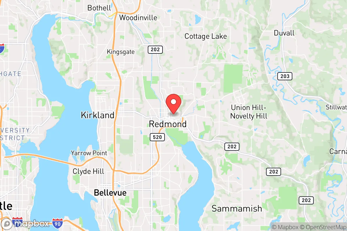
Redmond’s geography is a double-edged sword. It lies on the eastern shore of Lake Sammamish, with the Cascade Range to the east and the Puget Sound lowlands to the west. The area benefits from a mild maritime climate—rarely below freezing in winter, rarely above 80°F in summer—which means year-round growing seasons are possible with minimal infrastructure. Annual rainfall averages around 37 inches, providing reliable surface water from the Sammamish River and numerous smaller creeks. The surrounding forests offer ample cover, firewood, and game, though large game populations are modest compared to more rural parts of the state. The terrain is hilly but not mountainous, offering some natural defensibility through limited road access points—especially east toward the Cascades. However, the same geography that provides water and timber also funnels population movement through a few key corridors, which becomes a liability when considering evacuation or supply routes during a crisis.
Risks, exposures, and proximity to fallout-relevant landmarks
This is where Redmond’s strategic calculus turns sharply negative. The city is less than 15 miles from downtown Seattle, a major population center with multiple high-value targets: the Port of Seattle, Boeing facilities, Amazon headquarters, and the region’s largest fuel and chemical storage depots. In a scenario involving civil unrest, a coordinated attack, or a major natural disaster, Redmond would be directly in the path of any cascading failure from Seattle. The I-405 and SR-520 corridors, which connect Redmond to Bellevue and Seattle, would become impassable chokepoints during an evacuation. Additionally, Redmond itself is home to Microsoft’s global headquarters, a massive corporate campus that would be a prime target for cyberattacks, physical sabotage, or civil disruption. The concentration of tech infrastructure also means the area is heavily dependent on the power grid and internet connectivity—both fragile in a prolonged emergency. The nearby Puget Sound Naval Shipyard in Bremerton and Joint Base Lewis-McChord south of Tacoma are military installations that, while protective in some scenarios, also represent potential targets. For a prepper, the proximity to these landmarks means Redmond is a high-risk zone, not a safe haven.
Practical resilience for a relocator: food, water, energy, and defensibility
On paper, Redmond has strong natural resources. The Sammamish River and Lake Sammamish provide abundant fresh water, but access is controlled by public parks and private shoreline—meaning you cannot simply walk to the lake and fill containers without trespassing or drawing attention. Most residential properties are on municipal water, which is vulnerable to contamination or service interruption. For off-grid water, a well is possible but expensive and regulated by King County. Food resilience is limited: the area has some community gardens and small farms, but the vast majority of food is trucked in via the I-5 and I-90 corridors. In a supply chain disruption, grocery shelves would empty within 48 hours. Energy is another weak point. Puget Sound Energy provides electricity via overhead lines that are vulnerable to windstorms, ice, and seismic events. The Cascadia Subduction Zone earthquake scenario—a 9.0+ megathrust event—would devastate the region, with Redmond experiencing severe shaking, liquefaction in low-lying areas, and likely weeks to months without power or fuel. Natural gas lines would rupture, and road access would be cut by landslides and bridge failures. Defensibility is poor: Redmond is a suburban grid of cul-de-sacs and arterials, with no natural chokepoints to control access. The population density (roughly 3,500 people per square mile) means close neighbors and limited privacy. For a family seeking a retreat, this is not a defensible location. The best you can do is harden a single home, but you cannot secure the neighborhood.
The overall strategic picture for Redmond is one of calculated risk with a low probability of favorable outcomes in a major crisis. For the conservative relocator who values self-reliance, community cohesion, and distance from urban chaos, Redmond offers too many dependencies and too few escape routes. Its natural advantages—water, timber, mild climate—are real, but they are outweighed by its position in the bullseye of a metropolitan region with high-value targets and fragile infrastructure. If you are looking for a place to ride out a long-term disruption, look east of the Cascades, or north toward Skagit County. Redmond is a place to work and earn, not a place to survive. If you must relocate here, invest in a well, solar panels, a wood stove, and a solid evacuation plan that gets you out of the I-405 corridor within the first hour of any event. Otherwise, you are betting on the status quo holding—and that is not a bet a prepared person should make.
* Values derived from national, state, county, city and local statistics and may differ in a specific area. Last updated: 2026-04-21T10:56:45.000Z
Narrative content on this page is AI-generated and may contain mistakes. Verify any details that matter before acting on them.
ReloMaps may earn a commission from affiliate links at no extra cost to you.