Photo: Wikipedia
Strategic Assessment of Roanoke, TX
Multiple tactical vulnerabilities. Population density, target proximity, or disaster risk are likely compounding. A retreat property and exit planning is required.
What does the Strategic Assessment tell us?
Our Strategic Assessment grades tactical survivability of an area. Major population centers, military targets, fallout zones, natural disasters, and border exposure all drive risk — lower exposure means a more defensible position in a crisis.
This is heavily inspired by Joel Skousen's Strategic Relocation book. Highly recommended you checkout the book ($)What does this tell us?
Our Strategic Assessment grades tactical survivability of an area. Major population centers, military targets, fallout zones, natural disasters, and border exposure all drive risk — lower exposure means a more defensible position in a crisis.
This is heavily inspired by Joel Skousen's Strategic Relocation book. Highly recommended you checkout the book ($)Strategic Pillars

Key Distances
Regional Safe Places
Below is our recommended "safe zones" in Texas and the surrounding area based on our strategic heuristics. For most people, it's unrealistic to live in a “safe zone” full-time due to work, family or other personal reasons. They tend to be more rural. However, many of these areas are perfect for second homes and retreat properties that double as a vacation home or even a short-term rental.


Important Note: For informational purposes only. This does not mean nothing bad ever happens in the green zones. Please use common sense. This is based on public data and modeled with AI. We tried to take a conservative approach but mistakes happen. We update this regularly as new information becomes available.
Solar Generator Recommendations
Backup power matters more here than in safer locations. We've picked three solar generators across budgets and capacity tiers — start with the budget unit if you only need a few essentials, or step up if you want to run a fridge and HVAC for days at a time.

Jackery Portable Power Station Explorer 300
Budget OptionPower on the Go: Weighing only 11 lbs, it's convenient to set up and store with book-sized foldable solar panels

BLUETTI Portable Power Station AC180
Designed for both indoor and outdoor scenarios, AC180 is highly capable as it has a robost capacity and continuous output power.

EF ECOFLOW DELTA Pro Ultra Power Station
Upgraded PickEcoFlow DELTA Pro Ultra is a whole-home energy system designed to grow with your family. Integrated with the Smart Home Panel 2, it scales to meet your evolving energy needs — keeping your home powered, intelligent, and secure through every stage of life.
We earn a commission, at no additional cost to you.
Strategic Assessment Analysis
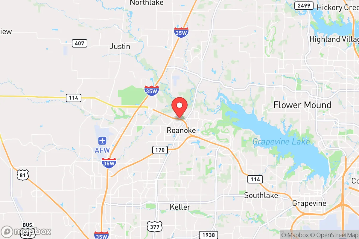
Roanoke, Texas, sits in a precarious but potentially advantageous position for those prioritizing resilience and preparedness. Located just 30 miles northwest of downtown Dallas and 20 miles from Fort Worth, it is close enough to major urban centers to access resources and infrastructure, yet far enough to avoid the immediate chaos of a metropolitan collapse. The town’s small population of roughly 10,000 and its position within Denton County—a region with a mix of suburban growth and rural pockets—offer a buffer against the worst of civic unrest, provided you plan ahead. For a relocator with a survivalist mindset, Roanoke’s key strength is its location along the Interstate 35W corridor, which provides both escape routes and supply chain access, but that same corridor also funnels risk from larger cities during a crisis.
Geographic position and natural advantages for long-term survival
Roanoke’s geography is defined by the rolling plains of North Texas, with the Trinity River basin to the east and the Cross Timbers ecoregion to the west. This terrain offers moderate defensibility—open fields for visibility and scattered wooded areas for cover—but it is not mountainous or heavily forested, so concealment is limited. The area’s elevation, around 650 feet, provides no significant vantage points, but the flat-to-gently-rolling landscape makes it easier to monitor movement from a distance. A major natural advantage is the proximity to the Elm Fork of the Trinity River, roughly 10 miles east, which could serve as a water source in a prolonged grid-down scenario, though it requires treatment. The local aquifer, the Trinity Group, is a reliable groundwater source, and many rural properties in the county have private wells—a critical asset for off-grid living. The climate is temperate with hot summers and mild winters, reducing the risk of extreme weather-related failures, though tornadoes and severe thunderstorms are a recurring threat from spring through fall. For a prepper, the lack of major natural barriers (mountains, large lakes) means you must rely on man-made defenses and community networks rather than terrain for security.
Risks, exposures, and proximity to fallout-relevant landmarks
The biggest risk for Roanoke is its proximity to high-value targets in the Dallas-Fort Worth metroplex. DFW International Airport, about 25 miles southeast, is a primary node for military and civilian air traffic, making it a potential target in a conflict scenario. The nearby Alliance Airport in Fort Worth, a major cargo and logistics hub, is another concern. Additionally, the region hosts several chemical plants and refineries along the Trinity River corridor, including facilities in Denton and Lewisville, which could release hazardous materials during a disaster or attack. Roanoke itself is not near any known nuclear power plants—the closest is Comanche Peak in Glen Rose, about 70 miles southwest—but the prevailing winds from the south could carry fallout from a strike on DFW or the Dallas central business district. The town’s location along I-35W also makes it a natural evacuation route for Dallas residents fleeing north, which could lead to gridlock and resource depletion during a mass evacuation event. For a conservative-minded relocator, the presence of a large, transient population in nearby cities (Denton’s university students, Fort Worth’s industrial workers) increases the risk of civil unrest spilling over into smaller communities. The 2020 protests in Dallas and Fort Worth demonstrated how quickly urban tensions can radiate outward, and Roanoke’s police force of about 30 officers would be overwhelmed in a widespread breakdown of order.
Practical resilience for a relocator: food, water, energy, and defensibility
For a relocator serious about self-sufficiency, Roanoke offers a mixed bag. The town is in Denton County, which has some agricultural land, but most of the immediate area is suburban development or ranchland, not small-scale farming. You would need to secure a property with at least 5-10 acres to grow meaningful food, and the clay-heavy soil requires amendment for vegetable gardens. Local water is generally available via municipal supply, but a private well is essential for resilience—drilling costs in the area run $5,000-$15,000 depending on depth. Rainwater harvesting is viable given the average 36 inches of annual precipitation, but storage tanks and filtration systems are a must. Energy-wise, the Texas grid is notoriously unreliable during extreme weather, as the 2021 winter storm showed, when Roanoke lost power for days. Solar panels with battery storage are a wise investment, and natural gas generators are common among preppers here. Defensibility is moderate: the town’s layout is a mix of older homes with large lots and newer subdivisions with tight HOA restrictions—avoid HOAs if possible, as they limit modifications like fences, sheds, or visible security measures. The best properties are on the outskirts, near the unincorporated areas of Denton County, where you can establish a perimeter and store supplies without drawing attention. Local gun culture is strong, with several shooting ranges and gun shops within 20 miles, and Texas’s constitutional carry law means you can defend your property without bureaucratic hurdles. For community resilience, Roanoke has a small but active church network and a local chapter of the Texas State Guard, which can be a resource for organized response during disasters.
The overall strategic picture for Roanoke is one of calculated risk. It is not a remote bunker location—you are still within a two-hour drive of 7 million people—but it offers a balance of access and buffer that suits a prepared individual or family. The key is to treat Roanoke as a base of operations, not a final redoubt. Stockpile supplies for at least 90 days, establish relationships with like-minded neighbors in the surrounding rural areas, and have a secondary bug-out location farther west (e.g., the Hill Country or the Panhandle) if the metroplex collapses. The town’s growth is accelerating—population doubled between 2010 and 2020—which brings both opportunity (more resources) and risk (more eyes on your preparations). For a conservative relocator who values community, self-reliance, and proximity to urban jobs without being swallowed by them, Roanoke is a solid choice, but only if you treat it as a starting point for a layered resilience strategy, not a safe haven in itself.
* Values derived from national, state, county, city and local statistics and may differ in a specific area. Last updated: 2026-05-11T19:32:13.000Z
Narrative content on this page is AI-generated and may contain mistakes. Verify any details that matter before acting on them.
ReloMaps may earn a commission from affiliate links at no extra cost to you.