Photo: Wikipedia
Strategic Assessment of Salinas, CA
Multiple tactical vulnerabilities. Population density, target proximity, or disaster risk are likely compounding. A retreat property and exit planning is required.
What does the Strategic Assessment tell us?
Our Strategic Assessment grades tactical survivability of an area. Major population centers, military targets, fallout zones, natural disasters, and border exposure all drive risk — lower exposure means a more defensible position in a crisis.
This is heavily inspired by Joel Skousen's Strategic Relocation book. Highly recommended you checkout the book ($)What does this tell us?
Our Strategic Assessment grades tactical survivability of an area. Major population centers, military targets, fallout zones, natural disasters, and border exposure all drive risk — lower exposure means a more defensible position in a crisis.
This is heavily inspired by Joel Skousen's Strategic Relocation book. Highly recommended you checkout the book ($)Strategic Pillars

Key Distances
Regional Safe Places
Below is our recommended "safe zones" in California and the surrounding area based on our strategic heuristics. For most people, it's unrealistic to live in a “safe zone” full-time due to work, family or other personal reasons. They tend to be more rural. However, many of these areas are perfect for second homes and retreat properties that double as a vacation home or even a short-term rental.


Important Note: For informational purposes only. This does not mean nothing bad ever happens in the green zones. Please use common sense. This is based on public data and modeled with AI. We tried to take a conservative approach but mistakes happen. We update this regularly as new information becomes available.
Solar Generator Recommendations
Backup power matters more here than in safer locations. We've picked three solar generators across budgets and capacity tiers — start with the budget unit if you only need a few essentials, or step up if you want to run a fridge and HVAC for days at a time.

Jackery Portable Power Station Explorer 300
Budget OptionPower on the Go: Weighing only 11 lbs, it's convenient to set up and store with book-sized foldable solar panels

BLUETTI Portable Power Station AC180
Designed for both indoor and outdoor scenarios, AC180 is highly capable as it has a robost capacity and continuous output power.

EF ECOFLOW DELTA Pro Ultra Power Station
Upgraded PickEcoFlow DELTA Pro Ultra is a whole-home energy system designed to grow with your family. Integrated with the Smart Home Panel 2, it scales to meet your evolving energy needs — keeping your home powered, intelligent, and secure through every stage of life.
We earn a commission, at no additional cost to you.
Strategic Assessment Analysis
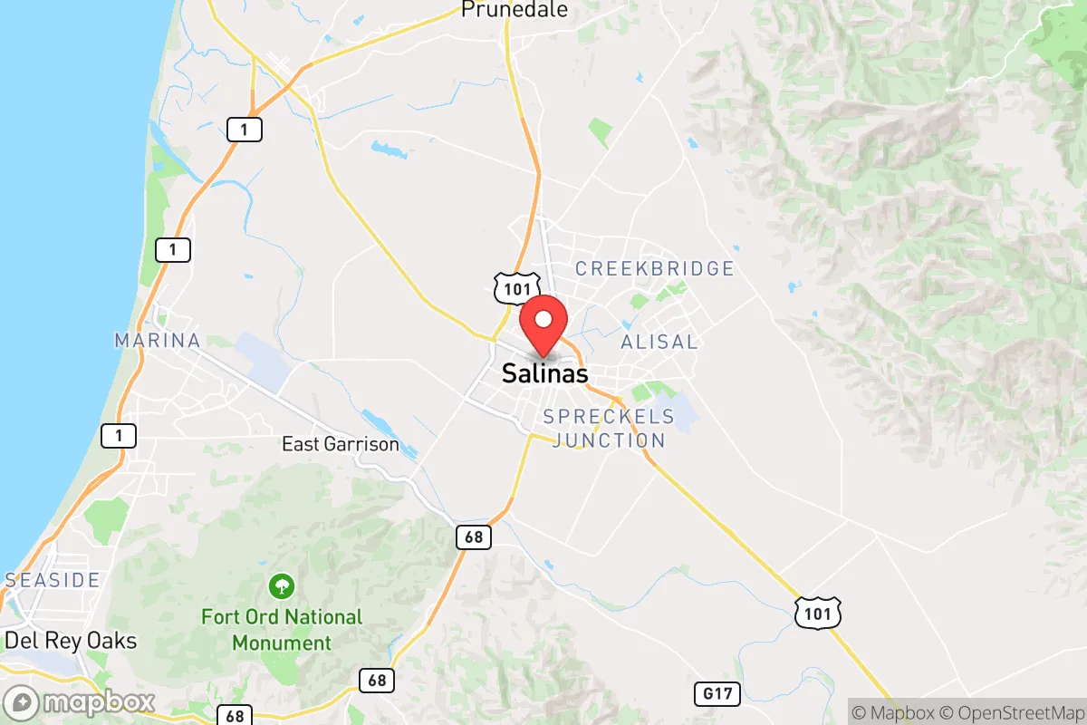
Salinas, California, presents a complex strategic picture for the conservative relocator focused on resilience. Its location in the fertile Salinas Valley offers genuine advantages in food security and water access, but its proximity to major urban centers and critical infrastructure introduces significant vulnerabilities. For those serious about long-term preparedness, Salinas is not a retreat but a potential staging ground—a place with resources that must be weighed against its exposure to the cascading failures of a densely populated state.
Geographic position and natural advantages for long-term survival
Salinas sits roughly 80 miles south of San Francisco and 20 miles inland from Monterey Bay, placing it in a transitional zone between the coast and the Central Valley. This position gives it a moderate Mediterranean climate—average highs in the 60s°F year-round—which reduces the heating and cooling demands that would strain off-grid setups. The area receives about 15 inches of rain annually, concentrated in winter, which is modest but workable with proper catchment. The real strategic asset is the Salinas Valley itself: one of the most productive agricultural regions in the United States. Known as the "Salad Bowl of the World," it produces over 60% of the nation's lettuce, artichokes, and strawberries, along with significant broccoli, celery, and wine grapes. For a relocator, this means local food supply chains are robust even in normal times, and in a disruption, the valley's farms could become a critical source of fresh produce. The nearby Gabilan and Santa Lucia mountain ranges also provide natural barriers to the east and west, offering some physical separation from the urban sprawl of the Bay Area and the coast. The Salinas River, while often seasonal, provides a groundwater recharge zone that supports the valley's agriculture, giving the area a water advantage over many other parts of California that are already facing severe drought restrictions.
Risks, exposures, and proximity to fallout-relevant landmarks
The most significant vulnerability for Salinas is its proximity to high-value, high-risk targets. The city lies within 20 miles of the Monterey-Salinas Highway (Highway 68) corridor, which connects to the Fort Hunter Liggett military installation about 60 miles south. While not a primary nuclear target, Fort Hunter Liggett is a major training center for the U.S. Army and could be a secondary target in a conflict scenario. More concerning is the proximity to the Diablo Canyon Power Plant—a nuclear facility located about 90 miles south near San Luis Obispo. While not within the immediate fallout zone, a catastrophic event at Diablo Canyon could place Salinas downwind depending on prevailing weather patterns. The city is also within 100 miles of the Port of Oakland and the Port of San Francisco, both critical economic nodes that could become targets for sabotage or disruption during civil unrest. The major highways—US-101 and CA-156—run directly through Salinas, making it a chokepoint for traffic moving between the Bay Area and the Central Coast. In a mass evacuation scenario, these roads would become impassable, trapping residents. Additionally, the area is not immune to natural disasters: the San Andreas Fault runs about 30 miles to the east, and the city sits on alluvial soils that are prone to liquefaction during a major earthquake. Flooding from the Salinas River is a recurring risk, with the 1995 and 2023 floods causing significant damage to low-lying neighborhoods. For a prepper, these factors mean that Salinas is a location that requires active mitigation—not a place to simply hunker down and wait out a crisis.
Practical resilience for a relocator: food, water, energy, and defensibility
On the practical side, Salinas offers genuine resilience advantages that are rare in California. Food security is the strongest draw: the valley's agricultural output means that even in a supply chain disruption, local farmers' markets and direct-from-farm sales can provide fresh produce. Many farms are family-owned and operate on a scale that allows for barter and community-based distribution. Water access is better than most of the state: the Salinas Valley Groundwater Basin provides a reliable source, though it is under increasing regulatory pressure from the Sustainable Groundwater Management Act (SGMA). For a relocator with a well, this is a significant asset, but it requires navigating California's complex water rights and permitting system. Energy infrastructure is a mixed bag: PG&E provides electricity, and the area is prone to public safety power shutoffs (PSPS) during high-wind events, which can last days. Solar with battery storage is a near-necessity for anyone serious about resilience. Natural gas is available in most urban areas, but propane delivery is common in rural parts of the valley. Defensibility is limited: the city itself is flat and open, with few natural chokepoints. The surrounding agricultural land offers some buffer, but the population density of Monterey County (over 430,000 people) means that in a collapse scenario, Salinas would be a destination for refugees from the coast and the Bay Area. The city's crime rate is already elevated—violent crime is about 2.5 times the national average—and this would likely worsen in a crisis. For a relocator, the best strategy is to secure property on the outskirts, ideally in the foothills of the Gabilan or Santa Lucia ranges, where defensible space and escape routes are more viable. The local gun culture is present but not as pronounced as in rural areas of the Central Valley; Monterey County has a mix of liberal coastal towns and conservative agricultural communities, so firearm ownership is legal but requires awareness of California's strict laws.
The overall strategic picture for Salinas is one of calculated risk. It offers genuine food and water advantages that are hard to find elsewhere in California, and its climate is forgiving for off-grid living. But the proximity to major urban centers, critical infrastructure, and natural disaster zones means that a relocator must be prepared for rapid evacuation or extended isolation. For the conservative prepper, Salinas is not a final destination—it is a base of operations that requires constant vigilance, a robust supply chain, and a network of like-minded individuals. If you can secure a property with a well, solar, and defensible terrain on the valley's edge, and you are willing to navigate California's regulatory environment, Salinas can work. But if you are looking for a low-profile, low-risk retreat, the Sierra Nevada foothills or the far northern counties of California offer better isolation. Salinas is a compromise—a place where the resources are real, but the threats are equally real.
* Values derived from national, state, county, city and local statistics and may differ in a specific area. Last updated: 2026-04-19T08:41:49.000Z
Narrative content on this page is AI-generated and may contain mistakes. Verify any details that matter before acting on them.
ReloMaps may earn a commission from affiliate links at no extra cost to you.