
Photo: Wikipedia
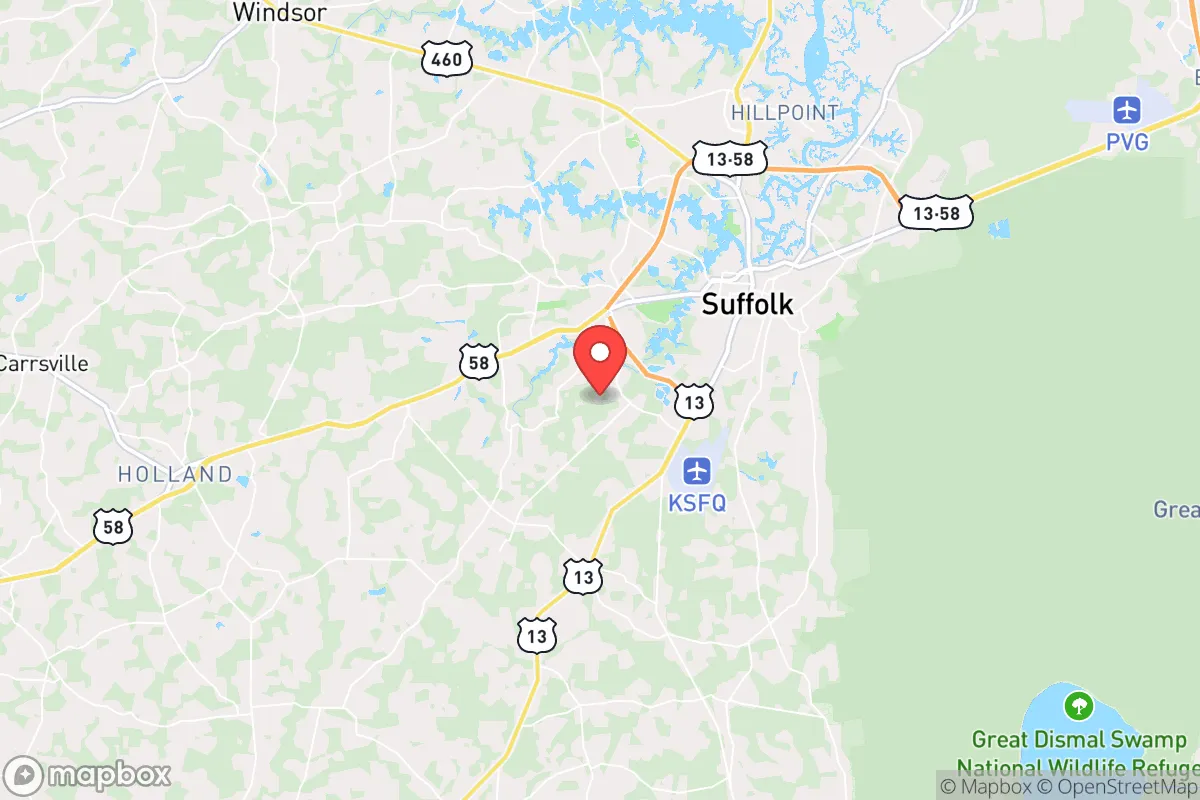
Strategic Assessment of Suffolk, VA
Meaningful friction. Expect exposure to either population pressure, blast zones, or natural disaster risk. Consider buying a retreat property.
What does the Strategic Assessment tell us?
Our Strategic Assessment grades tactical survivability of an area. Major population centers, military targets, fallout zones, natural disasters, and border exposure all drive risk — lower exposure means a more defensible position in a crisis.
This is heavily inspired by Joel Skousen's Strategic Relocation book. Highly recommended you checkout the book ($)What does this tell us?
Our Strategic Assessment grades tactical survivability of an area. Major population centers, military targets, fallout zones, natural disasters, and border exposure all drive risk — lower exposure means a more defensible position in a crisis.
This is heavily inspired by Joel Skousen's Strategic Relocation book. Highly recommended you checkout the book ($)Strategic Pillars

Key Distances
Regional Safe Places
Below is our recommended "safe zones" in Virginia and the surrounding area based on our strategic heuristics. For most people, it's unrealistic to live in a “safe zone” full-time due to work, family or other personal reasons. They tend to be more rural. However, many of these areas are perfect for second homes and retreat properties that double as a vacation home or even a short-term rental.


Important Note: For informational purposes only. This does not mean nothing bad ever happens in the green zones. Please use common sense. This is based on public data and modeled with AI. We tried to take a conservative approach but mistakes happen. We update this regularly as new information becomes available.
Solar Generator Recommendations
Backup power matters more here than in safer locations. We've picked three solar generators across budgets and capacity tiers — start with the budget unit if you only need a few essentials, or step up if you want to run a fridge and HVAC for days at a time.

Jackery Portable Power Station Explorer 300
Budget OptionPower on the Go: Weighing only 11 lbs, it's convenient to set up and store with book-sized foldable solar panels

BLUETTI Portable Power Station AC180
Designed for both indoor and outdoor scenarios, AC180 is highly capable as it has a robost capacity and continuous output power.

EF ECOFLOW DELTA Pro Ultra Power Station
Upgraded PickEcoFlow DELTA Pro Ultra is a whole-home energy system designed to grow with your family. Integrated with the Smart Home Panel 2, it scales to meet your evolving energy needs — keeping your home powered, intelligent, and secure through every stage of life.
We earn a commission, at no additional cost to you.
Strategic Assessment Analysis
Suffolk, Virginia, presents a mixed bag for the strategic relocator operating with a prepper mindset. On one hand, its position as a rapidly growing independent city within the Hampton Roads region offers a surprising degree of logistical resilience, anchored by a diversified economy and a strong agricultural base. On the other hand, its proximity to the largest naval base on the East Coast and the urban sprawl of Norfolk and Virginia Beach introduces significant risk vectors that cannot be ignored. For the conservative-leaning individual or family prioritizing self-reliance and security, Suffolk is less a sanctuary and more a calculated position—one that requires careful preparation and a clear-eyed understanding of both its defensive strengths and its exposure to cascading failures.
Geographic position, natural buffers, and strategic depth for long-term security
Suffolk’s primary advantage lies in its geography. It is the westernmost city in the Hampton Roads metro, acting as a land bridge between the coastal urban core and the more rural, sparsely populated counties to the west—Isle of Wight, Southampton, and beyond. This positioning provides a natural buffer. While Norfolk and Virginia Beach are directly exposed to the Atlantic and the Chesapeake Bay, Suffolk sits inland, shielded from the most immediate effects of a hurricane storm surge or a naval-focused kinetic event. The city is bisected by the Nansemond River and dotted with the Great Dismal Swamp to the south, creating physical choke points and limited road networks that could be leveraged for perimeter control in a grid-down scenario. The area’s agricultural history is not just a talking point; it means a significant portion of the land remains in active farming and timber production. For a relocator, this translates to a local food supply chain that is not entirely dependent on trucking from distant states. The presence of the Dismal Swamp Canal and the Intracoastal Waterway also offers an alternative, off-road transportation corridor for moving goods or people if the interstates become compromised. This is not a remote mountain redoubt, but it is a defensible position with strategic depth that many coastal cities simply lack.
Risk exposures, proximity to high-value targets, and fallout considerations
The sobering reality is that Suffolk sits within the shadow of Naval Station Norfolk, the world’s largest naval base, located roughly 25 miles east. Joint Base Langley-Eustis is also within a 40-mile radius. In any major conflict scenario—whether conventional war or a large-scale terrorist attack—these are Tier 1 targets. A kinetic strike, EMP event, or even a major industrial accident at the Norfolk Naval Shipyard in nearby Portsmouth would have immediate and severe consequences for Suffolk. The city would likely be overwhelmed by evacuees from the coast, straining water, fuel, and medical resources within hours. Furthermore, Suffolk is home to its own industrial infrastructure, including the large Virginia International Gateway container port and multiple rail yards. While these are economic assets, they are also potential choke points for supply chain disruption and could become secondary targets. The risk of fallout from a nuclear detonation at the naval base or a strike on the port is a real, if low-probability, concern. The prevailing winds in the region blow from the southwest, meaning fallout from a coastal event could drift directly over Suffolk. For the prepper, this means any retreat plan must account for the possibility of a contaminated eastern corridor and a need to move further west into the interior of Virginia or North Carolina. The city’s growth is also a risk: rapid suburban development is consuming farmland and increasing population density, which complicates long-term sustainability and makes the area more attractive to looters and desperate populations during a collapse.
Practical resilience for the relocator: food, water, energy, and defensibility
On the ground, Suffolk offers several practical advantages for a family serious about preparedness. The water table is high, and many rural properties have access to private wells, which is a critical advantage over city water systems that can fail or be contaminated. The local climate supports a long growing season, and the soil, while sandy in places, is workable for gardens and small-scale farming. The city’s zoning is relatively permissive for keeping livestock, including chickens and goats, on parcels of an acre or more. Energy resilience is a mixed picture. The grid is served by Dominion Energy, which has a mixed reliability record during storms, but the prevalence of trees and open land makes solar panel installation feasible for off-grid backup. Natural gas is available in many subdivisions, but a prepper should prioritize a wood-burning stove or a propane generator with a large tank. Defensibility is neighborhood-dependent. The older, established areas near downtown and along the Nansemond River have a more traditional street grid and closer neighbors, which is good for community defense but bad for privacy. The newer suburban subdivisions on the western edge, near the Suffolk city line with Isle of Wight, offer larger lots, cul-de-sacs, and more wooded buffer zones. These areas are easier to secure and monitor. The biggest practical weakness is the road network. Major arteries like US-58, US-460, and I-664 are the only ways in and out, and they will become parking lots during an evacuation. A relocator must have a secondary route plan that uses back roads and unpaved farm lanes to reach the rural counties to the west. Stockpiling fuel is non-negotiable here, as gas stations will be drained within hours of a major event.
In the final strategic assessment, Suffolk is best understood as a forward operating base rather than a final redoubt. It offers the economic opportunity and community infrastructure that many conservative families need to maintain a normal life while building their preparedness capabilities. The local gun culture is strong, with multiple ranges and a supportive sheriff’s department, and the agricultural sector provides a genuine food security buffer. However, the risks from its proximity to the Hampton Roads military-industrial complex and the urban population centers are real and cannot be mitigated by personal preparation alone. The wise relocator will treat Suffolk as a stepping stone—a place to build skills, store supplies, and network with like-minded neighbors while maintaining a clear, practiced plan to move further inland if the balloon goes up. It is not a bunker, but it is a viable, defensible position for those who understand that true security is a process, not a destination.
* Values derived from national, state, county, city and local statistics and may differ in a specific area. Last updated: 2026-05-02T02:13:14.000Z
Narrative content on this page is AI-generated and may contain mistakes. Verify any details that matter before acting on them.
ReloMaps may earn a commission from affiliate links at no extra cost to you.