Photo: Wikipedia
Strategic Assessment of Spokane County
Workable tactical position. Some exposure to population density or targets, but generally defensible in a crisis.
What does the Strategic Assessment tell us?
Our Strategic Assessment grades tactical survivability of an area. Major population centers, military targets, fallout zones, natural disasters, and border exposure all drive risk — lower exposure means a more defensible position in a crisis.
This is heavily inspired by Joel Skousen's Strategic Relocation book. Highly recommended you checkout the book ($)What does this tell us?
Our Strategic Assessment grades tactical survivability of an area. Major population centers, military targets, fallout zones, natural disasters, and border exposure all drive risk — lower exposure means a more defensible position in a crisis.
This is heavily inspired by Joel Skousen's Strategic Relocation book. Highly recommended you checkout the book ($)Strategic Pillars

Key Distances
Strategic Assessment Analysis
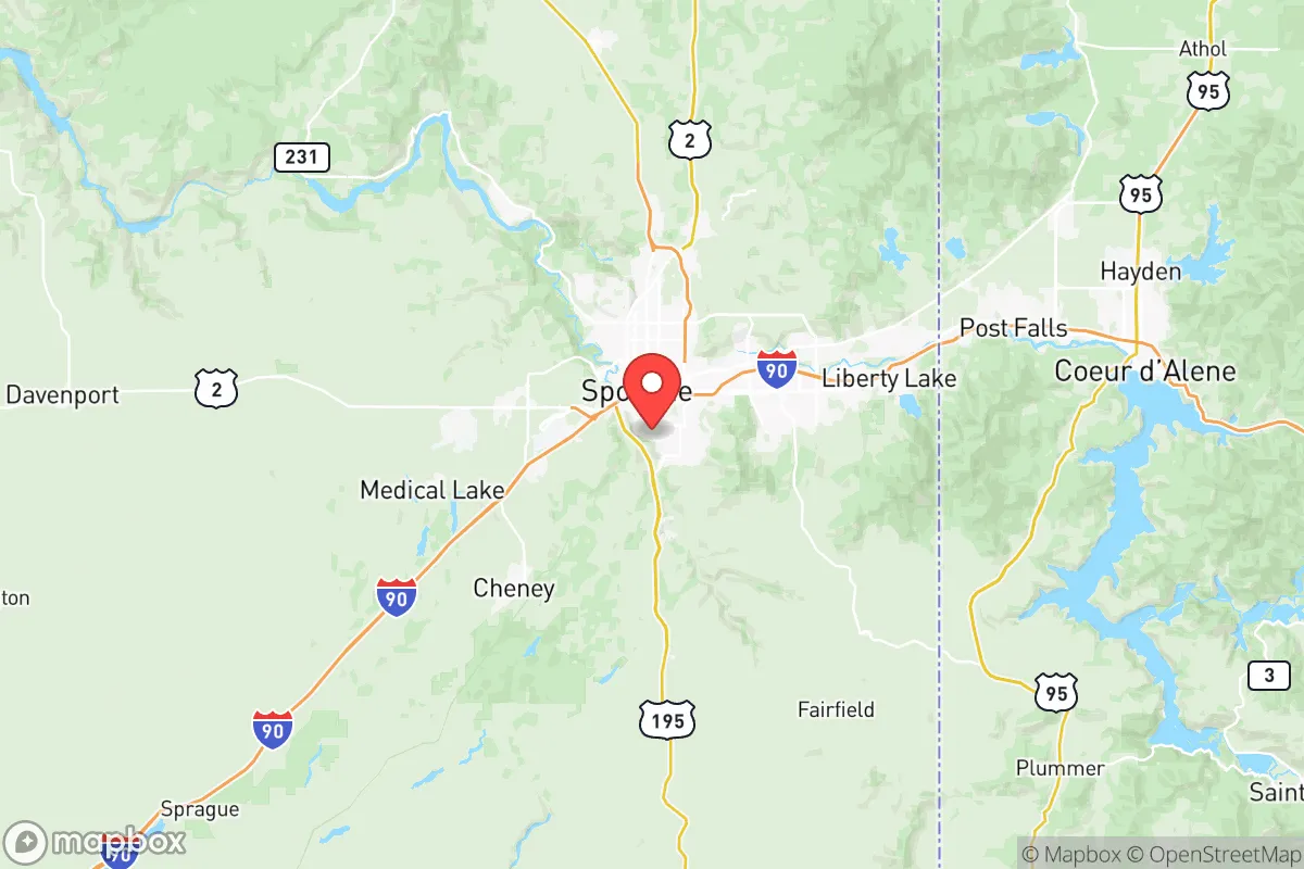
Spokane County presents a mixed bag for anyone serious about strategic relocation. On one hand, you’ve got the Spokane River and the massive Spokane Valley-Rathdrum Prairie Aquifer providing reliable fresh water, plus a location east of the Cascades that buffers you from the worst of coastal chaos. On the other hand, Fairchild Air Force Base sits right in the county – a prime target in any major conflict – and Spokane itself is a mid-sized city (pop. ~230,000) that could become a magnet for unrest or refugee flows. The county’s eastern towns – Deer Park, Newman Lake, Chattaroy – offer more defensible space, but you can’t ignore the fact that Hanford’s nuclear waste site lies less than 130 miles southwest, with prevailing winds that could send fallout across the Palouse. For a conservative prepper weighing self-sufficiency against proximity to threats, Spokane County is worth a hard look, but nowhere near a slam dunk.
Why Spokane County’s geographic position and natural advantages matter for survival
Strategically, Spokane County sits at a critical intersection. It’s far enough inland to avoid direct tsunami, hurricane, or Cascadia Subduction Zone collapse – but it’s still connected to the West Coast via Interstate 90 and the Burlington Northern rail line. That accessibility cuts both ways: it’s good for resupply in a stable scenario, but it’s also a major evacuation corridor that will clog fast during a crisis. The county’s natural advantages are concentrated around water and terrain. The Spokane Valley-Rathdrum Prairie Aquifer is one of the largest and most productive aquifers in the country, providing clean groundwater to most of the county without massive treatment infrastructure. The Spokane River runs through the heart of the area, and smaller tributaries like the Little Spokane River water the northern parts. For a relocator, a rural property with a drilled well in the Deer Park or Colbert area gives you a solid water security baseline. The terrain is a mix of rolling basalt plateaus, pine forests, and the foothills of Mount Spokane. The forests offer cover, firewood, and game (deer, elk in the northern Selkirk ranges). Southern parts of the county blend into the Palouse wheat belt – that’s good for long-term food production, but the open farmland leaves you exposed if you need to stay hidden. Neighboring Kootenai County, Idaho, with places like Coeur d’Alene and Post Falls, is just across the border – adding an extra escape route or a place to pivot if the county becomes too hot. But remember, that same border might see checkpoints or panic in a national emergency.
Fallout risks, military targets, and exposure to Cascadia chaos
The biggest red flag in Spokane County is Fairchild Air Force Base, home to the 92nd Air Refueling Wing and a major tanker fleet. In a peer-level conflict or nuclear exchange, Fairchild is a primary target. Any relocator should assume that the base and the surrounding area (Airway Heights, western Spokane) will be ground zero for a strike or a conventional attack. That puts a hard radius of danger around roughly the western third of the county. Additionally, the Hanford Site – the former plutonium production facility and current nuclear waste storage area – lies about 130 miles southwest. Prevailing winds blow from the southwest most of the year, meaning a Hanford accident or a deliberate attack could spread airborne contamination across Spokane County, especially the southern and central portions. Spokane International Airport is also a logical target in any disruption of military logistics. On the civil unrest front, Spokane has seen its share of downtown protests and homelessness surges. The city’s population density (about 2,400/sq mi) is high enough that a cascade failure of utilities could trigger mass displacement toward rural areas. Interstate 90 will likely become a parking lot if a large-scale evacuation is attempted. Your best bet to avoid these risks is to locate in the northeastern quadrant of the county – north of the Spokane River and east of Highway 395 – in towns like Deer Park, Springdale, or Newman Lake. Those areas are far enough from Fairchild to reduce fallout risk from a direct hit, and the prevailing winds would push any Hanford contamination toward the southeast, not the northeast.
What practical resilience looks like for relocators in Spokane County
If you’re serious about hunkering down here, you need to think through food, water, energy, and defensibility – and the county has bright spots and weak points for each. Water is the strongest asset. A private well drilled into the Spokane aquifer can give you hundreds of gallons per day with a simple hand pump or solar pump. The water table is shallow in many areas (50–150 feet), making it feasible to dig a driven well if you have the know-how. Food is a mixed picture. The Palouse to the south is some of the most productive wheat and pulse (lentils, chickpeas) land in the nation, but those are industrial operations – you won’t easily pocket that grain. Small-scale agriculture is viable in the north and east, especially in the valleys around Deer Park and along the Pend Oreille River. You’ll want to plan your own gardens and livestock; the growing season is short (130–150 frost-free days) but decent for potatoes, root vegetables, and cold-hardy greens. Energy is more vulnerable. The county is heavily dependent on Avista Utilities (hydro, natural gas, coal). The Grand Coulee Dam, about 80 miles west, is a giant hydroelectric source, but it’s also a tempting sabotage target. A grid-down scenario could leave you in the dark for weeks. Solar is viable – Spokane gets about 200 sunny days per year – but you’ll need battery storage to get through winter cloud banks. Wood heat is a solid backup; the National Forest lands provide fuel if you can secure a permit or harvest on private property. Defensibility varies by chosen town. Deer Park (pop. ~4,000) has a small-town feel with a main street, a grocery, and enough distance from Spokane to deter casual foot traffic. Newman Lake is more isolated, with only a couple of paved roads in – easy to monitor. Cheney, on the other hand, sits too close to Spokane and hosts Eastern Washington University, which could become an unruly camp in a collapse. Your most secure option is likely a parcel in the foothills northeast of Colbert or southwest of Mount Spokane – limited access, good elevation for observation, and a tight-knit rural community that tends to be armed and self-reliant.
Overall, Spokane County gives you a viable but imperfect strategic buffer. It’s not the Montana hideout or Idaho panhandle stronghold that some preppers idealize – the presence of Fairchild AFB, Hanford’s lingering shadow, and the Spokane urban core create real exposure. But if you pick the right micro-location (northeast of Spokane, away from major roads, on a well-equipped homestead), you gain access to abundant water, agricultural potential, and a low-crime rural environment. The conservative tilt of the eastern rural precincts (most of the county north of the river voted 65–75% Republican in recent cycles) aligns with a community that values self-reliance and gun rights. For a single individual or a family who can afford to drill a well, install solar, and stock a year’s worth of supplies, Spokane County offers a reasonable base camp – as long as you keep a close
* Values derived from national, state, county, city and local statistics and may differ in a specific area. Last updated: 2026-06-03T01:58:47.000Z
Narrative content on this page is AI-generated and may contain mistakes. Verify any details that matter before acting on them.
ReloMaps may earn a commission from affiliate links at no extra cost to you.